A dam is a barrier that stops or restricts the flow of surface water or underground streams. Reservoirs created by dams not only suppress floods but also provide water for activities such as irrigation, human consumption, industrial use, aquaculture, and navigability. Hydropower is often used in conjunction with dams to generate electricity. A dam can also be used to collect or store water which can be evenly distributed between locations. Dams generally serve the primary purpose of retaining water, while other structures such as floodgates or levees are used to manage or prevent water flow into specific land regions.
The Gardiner Dam on the South Saskatchewan River in Saskatchewan is the third largest embankment dam in Canada and one of the largest embankment dams in the world. Construction on Gardiner Dam and the smaller Qu'Appelle River Dam was started in 1959 and completed in 1967, creating Lake Diefenbaker upstream and diverting a considerable portion of the South Saskatchewan's flow into the Qu'Appelle River. The dam rises 64 metres (209 feet) in height, is almost 5 km (3.1 mi) long and has a width of 1.5 km (0.93 mi) at its base with a volume of 65,000,000 cubic meters. The dam is owned and operated by the Saskatchewan Water Security Agency.

New Bullards Bar Dam is a variable radius concrete arch dam constructed in the early 1960s in California on the North Yuba River. Located near the town of Dobbins in Yuba County, the dam forms the New Bullards Bar Reservoir, which can hold about 969,600 acre⋅ft (1.1960×10⁹ m3) of water. The dam serves for irrigation, drinking water and hydroelectric power generation.

Pine Flat Dam is a concrete gravity dam on the Kings River in the Central Valley of Fresno County, California United States. Situated about 28 miles (45 km) east of Fresno, the dam is 440 feet (130 m) high and impounds Pine Flat Lake, in the foothills of the Sierra Nevada just outside the boundary of Kings Canyon National Park. The dam's primary purpose is flood control, with irrigation, hydroelectric power generation and recreation secondary in importance.

A reservoir is an enlarged lake behind a dam. Such a dam may be either artificial, usually built to store fresh water, or it may be a natural formation.

Nagarjuna Sagar Dam is a masonry dam across the Krishna River at Nagarjuna Sagar which straddles the border between Palnadu district in Andhra Pradesh and Nalgonda district in Telangana. The dam provides irrigation water to the districts of Palnadu, Guntur, Nalgonda, Prakasam, Khammam, Krishna, and parts of West Godavari. It is also a source of electricity generation for the national grid.

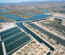
The New Waddell Dam is an embankment dam on the Agua Fria River in Maricopa County, Arizona, 35 miles (56 km) northwest of Phoenix. It serves as part of the Central Arizona Project (CAP) while also providing water for the Maricopa Water District. The dam creates Lake Pleasant with water from the Agua Fria and also the CAP aqueduct. In addition, it affords flood protection, hydroelectric power production and recreational opportunities. Construction on the dam began in 1985 and ended in 1994. Its reservoir submerged the Old Waddell Dam which was completed in 1927 after decades of planning.

Navajo Dam is a dam on the San Juan River, a tributary of the Colorado River, in northwestern New Mexico in the United States. The 402-foot (123 m) high earthen dam is situated in the foothills of the San Juan Mountains about 44 miles (71 km) upstream and east of Farmington, New Mexico. It was built by the U.S. Bureau of Reclamation (Reclamation) in the 1960s to provide flood control, irrigation, domestic and industrial water supply, and storage for droughts. A small hydroelectric power plant was added in the 1980s.

The Rio Grande Project is a United States Bureau of Reclamation irrigation, hydroelectricity, flood control, and interbasin water transfer project serving the upper Rio Grande basin in the southwestern United States. The project irrigates 193,000 acres (780 km2) along the river in the states of New Mexico and Texas. Approximately 60 percent of this land is in New Mexico. Some water is also allotted to Mexico to irrigate some 25,000 acres (100 km2) on the south side of the river. The project was authorized in 1905, but its final features were not implemented until the early 1950s.

New Exchequer Dam is a concrete–faced, rock-fill dam on the Merced River in central California in the United States. It forms Lake McClure, which impounds the river for irrigation and hydroelectric power production and has a capacity of more than 1,000,000 acre-feet (1.2 km3). The Merced Irrigation District (MID) operates the dam and was also responsible for its construction.

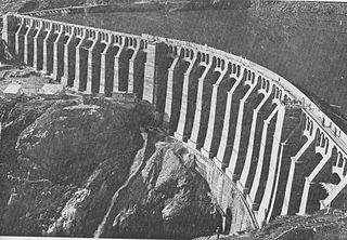
The Daniel-Johnson dam, formerly known as Manic-5, is a multiple-arch buttress dam on the Manicouagan River that creates the annular Manicouagan Reservoir. The dam is composed of 14 buttresses and 13 arches and is 214 km (133 mi) north of Baie-Comeau in Quebec, Canada. The dam was constructed between 1959 and 1970 for the purpose of hydroelectric power production and supplies water to the Manic-5 and Manic-5-PA power houses with a combined capacity of 2,660 MW. The dam is 214 m (702 ft) tall, 1,314 m (4,311 ft) long and contains 2,200,000 m3 (2,900,000 cu yd) of concrete, making it the largest dam of its type in the world.

Caliraya Dam is an embankment dam located in the town of Lumban province of Laguna, in the Sierra Madre Mountain Range of the Philippines. The reservoir created by the dam, Lake Caliraya, initially supplied one of the oldest hydroelectric plants in the Philippines, and later became a popular recreational area for numerous water sports and fishing. The dam's construction was started in 1939 under the supervision of the architecture firm of Pedro Siochi and Company and a small hydroelectric plant was operated in 1942.

New Don Pedro Dam, often known simply as Don Pedro Dam, is an earthen embankment dam across the Tuolumne River, about 2 miles (3.2 km) northeast of La Grange, in Tuolumne County, California. The dam was completed in 1971, after four years of construction, to replace the 1924 concrete-arch Don Pedro Dam.

Idamalayar Dam is a multipurpose concrete gravity dam located at Ennakkal between Ayyampuzha and Bhoothathankettu in Ernakulam district of Kerala on the Idamalayar, a tributary of the Periyar River in Kerala, South India. The dam however extends east as far as Malakkappara. Completed in 1985, with a length of 373 metres (1,224 ft) and a height of 102.8 metres (337 ft), the dam created a multipurpose reservoir covering 28.3 km2 (10.9 sq mi) in the scenic hills of the Anamalais.

Zengwen Dam, also spelled Tsengwen Dam, is a major earthen dam in Dapu Township, Chiayi County, Taiwan on the Zengwen River. It is the third tallest dam in Taiwan, and forms Zengwen Reservoir (曾文水庫), the biggest reservoir in Taiwan by volume. The dam stores water for irrigation of the Chianan Plain, Taiwan's most productive agricultural region, and provides flood control along the Zengwen River which flows through Tainan City. The dam supports a 50 megawatt hydroelectric power station.
The Gleno Dam was a multiple arch buttress dam on the Gleno Creek in the Valle di Scalve, northern Province of Bergamo, Italy. The dam was built between 1916 and 1923 with the purpose of producing hydroelectric power. The middle section of the dam collapsed on 1 December 1923, forty days after the reservoir was filled, causing widespread flooding that killed at least 356 people.

The Middle Rio Grande Project manages water in the Albuquerque Basin of New Mexico, United States. It includes major upgrades and extensions to the irrigation facilities built by the Middle Rio Grande Conservancy District and modifications to the channel of the Rio Grande to control sedimentation and flooding. The bulk of the work was done by the United States Bureau of Reclamation and the United States Army Corps of Engineers in the 1950s, but construction continued into the 1970s and maintenance is ongoing. The project is complementary to the San Juan–Chama Project, which transfers water from the San Juan River in the Colorado River Basin to the Rio Grande. Although distribution of water from the two projects is handled through separate allotments and contracts, there is some sharing of facilities including the river itself. The ecological impact on the river and the riparian zone was the subject of extended litigation after a group of environmentalists filed Rio Grande Silvery Minnow v. Bureau of Reclamation in 1999.
A detention dam is a dam built to catch surface runoff and stream water flow to regulate the water flow in areas below the dam. Detention dams are commonly used to reduce the damage caused by flooding or to manage the flow rate through a channel. Detention dams can also be constructed to replenish groundwater and trap sediment. Detention dams are one of three classifications of dams: storage dams, diversion dams, and detention dams. Storage dams store water for extended times for irrigation, livestock, municipal water supply, recreation, and hydroelectric power generation. Diversion dams raise the water level to redirect the water to a designated location. The diverted water typically supplies irrigation systems or reservoirs.
Deep Creek Dam is a major ungated concrete gravity dam across the Deep Creek in the Snowy Mountains of New South Wales, Australia. The dam's main purpose is for the diversion of water for generation of hydro-power and is the smallest of the sixteen major dams that comprise the Snowy Mountains Scheme, a vast hydroelectricity and irrigation complex constructed in south-east Australia between 1949 and 1974 and now run by Snowy Hydro.

The Yuba–Bear Hydroelectric Project is a complex hydroelectric scheme in the northern Sierra Nevada in California, tapping the upper Yuba River and Bear River drainage basins. The project area encompasses approximately 400 square miles (1,000 km2) in Nevada, Placer, and Sierra Counties. Owned by the Nevada Irrigation District, it consists of 16 storage dams plus numerous diversion and regulating dams, and four generating stations producing 425 million kilowatt hours of electricity each year. The Yuba–Bear Hydroelectric Project consists of the Bowman development, Dutch Flat No. 2 development, Chicago Park development, and Rollins development.