Philip Hardwick was an English architect, particularly associated with railway stations and warehouses in London and elsewhere. Hardwick is probably best known for London's demolished Euston Arch and its twin station, the original Birmingham Curzon Street, which stands today as the oldest railway terminus building in the world.
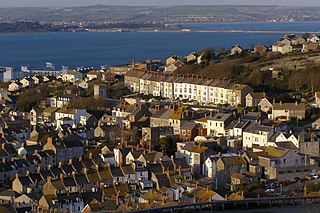
Fortuneswell is a village in Underhill on the Isle of Portland, in Dorset, England. It lies on steeply sloping land on the northern edge of the island, known as Underhill, where Chesil Beach connects the island to the mainland. Adjoining Fortuneswell are Chiswell to the west and Castletown to the north. Fortuneswell occupies the steeper land above sea level, whereas Chiswell and Castletown occupy flat land close to sea level, next to Chesil Beach and Portland Harbour respectively. Fortuneswell has a main shopping street, and along with Easton, is the main hub of the island's activities.

John Gwynn was an English architect and civil engineer, who became one of the founder members of the Royal Academy in 1768. He advocated greater control over planning in London, for which he produced detailed suggestions. His buildings include Magdalen Bridge and the Covered Market in Oxford, and several bridges over the River Severn.

Sandsfoot Castle, also known historically as Weymouth Castle, is an artillery fort constructed by Henry VIII near Weymouth, Dorset. It formed part of the King's Device programme to protect against invasion from France and the Holy Roman Empire, and defended the Weymouth Bay anchorage. The stone castle had an octagonal gun platform, linked to a residential blockhouse, and was completed by 1542 at a cost of £3,887. Earthwork defences were built around the landward side of the castle, probably in 1623. Sandsfoot saw service during the English Civil War, when it was held by Parliament and Royalists in turn during the conflict. It survived the interregnum but, following Charles II's restoration to the throne, the fortress was withdrawn from military use in 1665.

Easton is a village on the Isle of Portland in Dorset, England. The village is situated at Tophill, within the centre of the island. As with the rest of Portland's villages and settlements, Easton, including the settlements Reforne and Straits, has been designated as a conservation area, as it is a place of special architectural and historic interest. Easton, Wakeham and Reforne were designated pre-1974.
Weston is a village in Tophill on the Isle of Portland, Dorset, England. It abuts the main village Easton. As with the rest of Portland's villages and settlements, Weston has been designated as a conservation area, as it is a place of special architectural and historic interest. The village was designated in 1994.

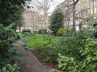
Manchester Square is an 18th-century garden square in Marylebone, London. Centred 950 feet (290 m) north of Oxford Street it measures 300 feet (91 m) internally north-to-south, and 280 feet (85 m) across. It is a small Georgian predominantly 1770s-designed instance in central London; construction began around 1776. The north side has a central mansion, Hertford House, flanked by approach ways; its first name was Manchester House — its use is since 1897 as the Wallace Collection (gallery/museum) of fine and decorative arts sits alongside the Madame Tussauds museum and the Wigmore Hall concert rooms. The square forms part of west Marylebone, most of which sees minor but overarching property interests held by one owner among which many buildings have been recognised by statutory protection.
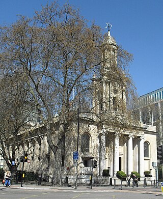
Holy Trinity Church, in Marylebone, Westminster, London, is a Grade I listed former Anglican church, built in 1828 and designed by John Soane. In 1818 Parliament passed an act setting aside one million pounds to celebrate the defeat of Napoleon. This is one of the so-called "Waterloo churches" that were built with the money. The building has an entrance off-set with four large Ionic columns. There is a lantern steeple, similar to St Pancras New Church, which is also on Euston Road to the east.
Montagu Square is a garden square in Marylebone, London. It is centred 550 metres north of Marble Arch. It spans 810 feet (250 m) by 150 feet (46 m). and is oriented on an axis of about NNW. Save for No.s 27 to 29 the long sides (NNW-SSE) are Grade II listed residential buildings.

Bryanston Square is an 800-by-200-foot garden square in Marylebone, London. Terraced buildings surround it — often merged, converted or sub-divided, some of which remain residential. The southern end has the William Pitt Byrne memorial fountain. Next to both ends are cycle parking spaces.

Cavendish Square is a public garden square in Marylebone in the West End of London. It has a double-helix underground commercial car park. Its northern road forms ends of four streets: of Wigmore Street that runs to Portman Square in the much larger Portman Estate to the west; of Harley Street which runs an alike distance; of Chandos Street which runs for one block and; of Cavendish Place which runs the same. The south side itself is modern: the rear façade and accesses to a flagship department store and office block. On the ground floors facing are Comptoir Libanais, Royal Bank of Scotland and Pret a Manger premises.
Lord's Old Ground was a cricket venue in London that was established by Thomas Lord in 1787. It was used mainly by Marylebone Cricket Club for major matches until 1810, after which a dispute about rent caused Lord to relocate.
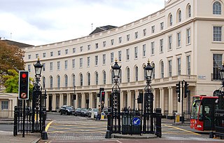
Park Crescent is at the north end of Portland Place and south of Marylebone Road in London. The crescent consists of elegant stuccoed terraced houses by the architect John Nash, which form a semicircle. The crescent is part of Nash's and wider town-planning visions of Roman-inspired imperial West End approaches to Regent's Park. It was originally conceived as a circus (circle) to be named Regent's Circus but instead Park Square was built to the north. The only buildings on the Regent's Park side of the square are small garden buildings, enabling higher floors of the Park Crescent buildings to have a longer, green northern view.

Park Square is a large garden square or private appendix to Regent's Park in London and is split from a further green, the long northern side of Park Crescent, by Marylebone Road and (single-entrance) Regent's Park tube station. It consists of two facing rows of large, very classically formed, stuccoed, terraced houses with decorative lower floor balconies and a colonnade of consecutive porticos by architect John Nash, and was built in 1823–24. Alike, shorter-length terraces flank its corners at right angles, equally Grade I listed buildings: Ulster Terrace, Ulster Place, St Andrew's Place and Albany Terrace.

Marylebone is an area in London, England and is located in the City of Westminster. It is in Central London and part of the West End. Oxford Street forms its southern boundary.

The George Inn is a Grade II-listed 18th-century public house on the Isle of Portland, Dorset, England. It is situated within the village of Easton, at the west end of the hamlet of Reforne. The pub is located close to St George's Church and St George's Centre.
Hinde Street is a street in the Marylebone district of the City of Westminster, London, that contains the Hinde Street Methodist Church and was home to the novelist Rose Macaulay until her death.

Christ Church, Marylebone, also called Christ Church, Lisson Grove, and Christ Church, Cosway Street, is a Grade II* listed former Church of England church, built in the 1820s in Marylebone in the City of Westminster to designs by Thomas and Philip Hardwick.
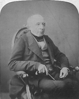
George Saxby Penfold was a Church of England clergyman, Rector of several parishes and active as a visiting preacher. In 1825 the University of Oxford awarded him the degree of Doctor of Divinity. A pluralist, for much of his life Penfold held the living of more than one benefice at once.

Dorset House is an apartment block in Marylebone in the City of Westminster. It is a noted example of Art Deco architecture and has been listed Grade II on the National Heritage List for England since March 1998. Dorset House occupies an entire block and is listed at the addresses of 128-130 Gloucester Place, 148-168 Marylebone Road, 1-9 Glentworth Street and 31-37 Melcombe Street.


