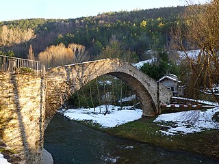
Dovadola

Last updated
Dovadola
Comune
Comune di Dovadola
Dovadola 2.jpg
Dovadola-Stemma.png
Coat of arms
Italy provincial location map 2015.svg
Red pog.svg
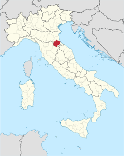
Dovadola
Location of Dovadola in Italy
Coordinates: 44°7′N11°53′E / 44.117°N 11.883°E / 44.117; 11.883
Country Italy
Region Emilia-Romagna
Province Forlì-Cesena (FC)
Government
  Mayor Francesco Tassinari
Area
  Total 38.97 km2 (15.05 sq mi)
Elevation 143 m (469 ft)
Population (31 July 2017) [1]
  Total 1,595
  Density 41/km2 (110/sq mi)
Demonym(s) Dovadolesi
Time zone CET (UTC+1)
  Summer (DST) CEST (UTC+2)
Postal code47013
Dialing code 0543
Patron saint St. Andrew Apostle
Saint day November 30
Website Official website

Dovadola (Romagnol : Dvêdla) is a comune (municipality) in the Province of Forlì-Cesena in the Italian region Emilia-Romagna, located about 60 kilometres (37 mi) southeast of Bologna and about 20 kilometres (12 mi) southwest of Forlì, on the road leading to Florence.

<i>Comune</i> third-level administrative divisions of the Italian Republic

The comune is a basic administrative division in Italy, roughly equivalent to a township or municipality.

Province of Forlì-Cesena Province of Italy

The province of Forlì-Cesena is a province in the Emilia–Romagna region of Italy. Its capital is the city of Forlì. The province has a population of 394,273 as of 2016 over an area of 2,378.4 square kilometres (918.3 sq mi). It contains 30 comuni and the provincial president is Davide Drei. Although located close to the independent Republic of San Marino, Forlì-Cesena does not share a land border with the sovereign state.

Italy republic in Southern Europe

Italy, officially the Italian Republic, is a country in Southern and Western Europe. Located in the middle of the Mediterranean Sea, Italy shares open land borders with France, Switzerland, Austria, Slovenia and the enclaved microstates San Marino and Vatican City. Italy covers an area of 301,340 km2 (116,350 sq mi) and has a largely temperate seasonal and Mediterranean climate. With around 61 million inhabitants, it is the fourth-most populous EU member state and the most populous country in Southern Europe.

Dovadola borders the following municipalities: Castrocaro Terme e Terra del Sole, Modigliana, Predappio, Rocca San Casciano.

Castrocaro Terme e Terra del Sole Comune in Emilia-Romagna, Italy

Castrocaro Terme e Terra del Sole a comune (municipality) in the Province of Forlì-Cesena in the Italian region Emilia-Romagna, located about 60 kilometres (37 mi) southeast of Bologna and about 10 kilometres (6 mi) southwest of Forlì.

Modigliana Comune in Emilia-Romagna, Italy

Modigliana is a comune (municipality) in the Province of Forlì-Cesena in the Italian region Emilia-Romagna, located about 50 kilometres (31 mi) southeast of Bologna and about 20 kilometres (12 mi) southwest of Forlì.

Predappio Comune in Emilia-Romagna, Italy

Predappio a town and comune in the province of Forlì-Cesena, in the region of Emilia-Romagna in Italy, with a population of 6,297. The town is best known for being the birthplace of Benito Mussolini, dictator of Italy from 1922 to 1943. Mussolini is buried at Predappio, and his mausoleum is a local tourist destination, as well as a site of pilgrimage for Fascists.

Related Research Articles

Borghi Comune in Emilia-Romagna, Italy

Borghi is a comune (municipality) in the Province of Forlì-Cesena in the Italian region Emilia-Romagna, located about 100 kilometres (62 mi) southeast of Bologna and about 35 kilometres (22 mi) southeast of Forlì.

Civitella di Romagna Comune in Emilia-Romagna, Italy

Civitella di Romagna is a comune (municipality) in the Province of Forlì-Cesena in the Italian region Emilia-Romagna, located about 70 kilometres (43 mi) southeast of Bologna and about 30 kilometres (19 mi) southwest of Forlì.

Gambettola Comune in Emilia-Romagna, Italy

Gambettola is a comune (municipality) in the Province of Forlì-Cesena in the Italian region Emilia-Romagna, located about 90 kilometres (56 mi) southeast of Bologna and about 25 kilometres (16 mi) southeast of Forlì. As of 31 December 2004, it had a population of 10,478 and an area of 7.6 square kilometres (2.9 sq mi).

Gatteo Comune in Emilia-Romagna, Italy

Gatteo is a comune (municipality) in the Province of Forlì-Cesena in the Italian region Emilia-Romagna, located about 90 kilometres (56 mi) southeast of Bologna and about 30 kilometres (19 mi) southeast of Forlì. As of 31 December 2004, it had a population of 7,252 and an area of 14.1 square kilometres (5.4 sq mi).

Mercato Saraceno Comune in Emilia-Romagna, Italy

Mercato Saraceno is a comune (municipality) in the Province of Forlì-Cesena in the Italian region Emilia-Romagna, located about 90 kilometres (56 mi) southeast of Bologna and about 35 kilometres (22 mi) southeast of Forlì.

Montiano Comune in Emilia-Romagna, Italy

Montiano is a comune (municipality) in the Province of Forlì-Cesena in the Italian region Emilia-Romagna, located about 90 kilometres (56 mi) southeast of Bologna and about 25 kilometres (16 mi) southeast of Forlì. As of 31 December 2004, it had a population of 1,573 and an area of 9.3 square kilometres (3.6 sq mi).

Portico e San Benedetto Comune in Emilia-Romagna, Italy

Portico e San Benedetto is a comune (municipality) in the Province of Forlì-Cesena in the Italian region Emilia-Romagna, located about 60 kilometres (37 mi) southeast of Bologna.

Rocca San Casciano Comune in Emilia-Romagna, Italy

Rocca San Casciano is a comune (municipality) in the Province of Forlì-Cesena in the Italian region Emilia-Romagna, located about 60 kilometres (37 mi) southeast of Bologna and about 25 kilometres (16 mi) southwest of Forlì.

Roncofreddo Comune in Emilia-Romagna, Italy

Roncofreddo is a town and comune (municipality) in the Province of Forlì-Cesena in the Italian region Emilia-Romagna, located about 90 kilometres (56 mi) southeast of Bologna and about 30 kilometres (19 mi) southeast of Forlì.

San Mauro Pascoli Comune in Emilia-Romagna, Italy

San Mauro Pascoli is a comune (municipality) in the Province of Forlì-Cesena in the Italian region Emilia-Romagna, located about 100 kilometres (62 mi) southeast of Bologna and about 35 kilometres (22 mi) southeast of Forlì. It is at some 7.5 kilometres (4.7 mi) from the sea, the frazione of San Mauro Mare facing it.

Santa Sofia, Emilia–Romagna Comune in Emilia–Romagna, Italy

Santa Sofia is a comune (municipality) in the Province of Forlì-Cesena in the Italian region Emilia–Romagna, located about 80 kilometres (50 mi) southeast of Bologna and about 35 kilometres (22 mi) southwest of Forlì.

Sogliano al Rubicone Comune in Emilia-Romagna, Italy

Sogliano al Rubicone is a comune (municipality) in the Province of Forlì-Cesena in the Italian region Emilia-Romagna, located about 90 kilometres (56 mi) southeast of Bologna and about 35 kilometres (22 mi) southeast of Forlì.

Tredozio Comune in Emilia-Romagna, Italy

Tredozio is a comune (municipality) in the Province of Forlì-Cesena in the Italian region Emilia-Romagna, located about 60 kilometres (37 mi) southeast of Bologna and about 30 kilometres (19 mi) southwest of Forlì.

Verghereto Comune in Emilia-Romagna, Italy

Verghereto is a comune (municipality) in the Province of Forlì-Cesena in the Italian region Emilia-Romagna, located about 90 kilometres (56 mi) southeast of Bologna and about 50 kilometres (31 mi) south of Forlì.

Forlì del Sannio Comune in Molise, Italy

Forlì del Sannio is a comune (municipality) in the Province of Isernia in the Italian region Molise, located about 45 kilometres (28 mi) northwest of Campobasso and about 12 kilometres (7 mi) northwest of Isernia.

Roccasicura Comune in Molise, Italy

Roccasicura is a comune (municipality) in the Province of Isernia in the Italian region Molise, located about 40 kilometres (25 mi) northwest of Campobasso and about 11 kilometres (7 mi) north of Isernia. As of 31 December 2004, it had a population of 610 and an area of 29.0 square kilometres (11.2 sq mi).

Vastogirardi Comune in Molise, Italy

Vastogirardi is a comune (municipality) in the Province of Isernia in the Italian region Molise, located about 40 kilometres (25 mi) northwest of Campobasso and about 20 kilometres (12 mi) north of Isernia. As of 31 December 2004, it had a population of 789 and an area of 60.9 square kilometres (23.5 sq mi).

San Clemente, Emilia-Romagna Comune in Emilia-Romagna, Italy

San Clemente is a comune (municipality) in the Province of Rimini, but before 1992 in the Province of Forlì, in the Italian region Emilia-Romagna, located about 120 kilometres (75 mi) southeast of Bologna, about 65 kilometres (40 mi) southeast of Forlì and about 11 kilometres (7 mi) south of Rimini.

References

  1. All demographics and other statistics: Italian statistical institute Istat.