The Humber Forts are two large fortifications in the mouth of the Humber Estuary in northern England: Haile Sand Fort and Bull Sand Fort.

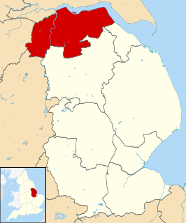
Humberside was a non-metropolitan and ceremonial county in Northern England from 1 April 1974 until 1 April 1996. It was composed of land from either side of the Humber Estuary, created from portions of East Riding of Yorkshire, West Riding of Yorkshire, and the district of Lindsey, Lincolnshire. The county council's headquarters was County Hall at Beverley, inherited from the East Riding, and its largest settlement and only city was Kingston upon Hull. The county stretched from Wold Newton in its northern tip to a different Wold Newton at its most southern point.

Barton-upon-Humber or Barton is a town and civil parish in North Lincolnshire, England. The population at the 2011 census was 11,066. It is situated on the south bank of the Humber Estuary at the southern end of the Humber Bridge. It is 46 miles (74 km) east of Leeds, 6 miles (10 km) south-west of Hull and 31 miles (50 km) north north-east of the county town of Lincoln. Other nearby towns include Scunthorpe to the south-west and Grimsby to the south-east.

The A15 is a major road in England. It runs north from Peterborough via Market Deeping, Bourne, Sleaford and Lincoln along a variety of ancient, Roman, and Turnpike alignments before it is interrupted at its junction with the M180 near Scawby. The road restarts 10 miles (16 km) east, and then continues north past Barton-upon-Humber, crossing the Humber on the Humber Bridge before terminating at Hessle near Kingston upon Hull.

Alkborough is a parish of 458 people in 192 households in North Lincolnshire, England, located near the northern end of The Cliff range of hills overlooking Trent Falls, the confluence of the River Trent and the River Ouse.

Healing is a village and civil parish in North East Lincolnshire, England. It is situated between Stallingborough and Great Coates, and 3 miles (5 km) west from Grimsby.

Cleethorpes is a constituency created in 1997, represented in the House of Commons of the UK Parliament since 2010 by Martin Vickers of the Conservative Party.
South Killingholme is a village and civil parish in North Lincolnshire, England. The population of the civil parish at the 2011 census was 1,108.

The Barton line is a railway line in North and North East Lincolnshire, England. It runs from Barton-upon-Humber south east to Cleethorpes and was designated by the Department for Transport as a community rail line in February 2007. Barton station is near to the Humber Bridge. It is situated on the south bank of the Humber Estuary

Stallingborough is a village and civil parish in North East Lincolnshire, England. The population of the civil parish at the 2011 census was 1,234.

Weelsby is located in the Weelsby Road area of eastern Grimsby, North East Lincolnshire, England. Previously separate from Grimsby, Weelsby Woods and Weelsby Hall lie within the area, as does the Grimsby Tennis Centre, Peaks Lane fire station, Saint Andrews Hospice, Saint Hughs Hospital and the local branch of the YMCA. It is home to a local drama group, the Weelsby Players and Weelsby Park Riding School. There is a Weelsby Tenants and Residents Association, which is represented on the Boroughwide Tenants Assembly.

South Humberside is a former postal county of England. It was introduced by the Royal Mail on 1 July 1974, when some addresses were altered in response to the changes in administration brought about under the Local Government Act 1972.
Lincolnshire is one of the few counties within the UK that still uses the eleven-plus to decide who may attend grammar school, in common with Buckinghamshire and Kent.

Barrow Haven is a hamlet and small port in North Lincolnshire, England. It was the site of a former ferry crossing that spanned from the Humber Estuary to Hull, serving as a place for ships and boats crossing the Humber to moor away from the tidal flow. A port continues to exist nearby and the area's rail access is based at the Barrow Haven railway station, a stop on the Barton Line.
Elkington is a civil parish in the East Lindsey district of Lincolnshire, England. It comprises the village of South Elkington, and the hamlets of North Elkington, Boswell, and Thorpe, and is situated approximately 3 miles (5 km) north-west from the market town of Louth.

The Port of Hull is a port at the confluence of the River Hull and the Humber Estuary in Kingston upon Hull, East Riding of Yorkshire, England.
Whitton railway station was a railway station, built by the North Lindsey Light Railway in Whitton, Lincolnshire. It was the northern terminus of the line from Scunthorpe railway station. It opened in 1907 and closed for passengers in 1925 and goods in 1951.
The south bank of the Humber Estuary in England is a relatively unpopulated area containing large scale industrial development built from the 1950s onward, including national scale petroleum and chemical plants as well as gigawatt scale gas fired power stations.