Drought in Chile

Last updated

Through its history, Chile was regularly affected by droughts. In the more arid parts of Chile droughts are produced when there are low amounts of snow accumulation in the Andes. [1] Chilean coastal drainage basins without snow accumulation are particularly vulnerable to drought. [1]

Contents

The territory of Central Chile has been affected by long-term droughts in 1280–1450, 1570–1650, 1770–1820 and 2010–present. [2] [3]

Historical droughts

San Carlos Canal in picture begun to be built in 1772 in response to years of drought. Canal San Carlos.JPG
San Carlos Canal in picture begun to be built in 1772 in response to years of drought.

Drought of 1770–82

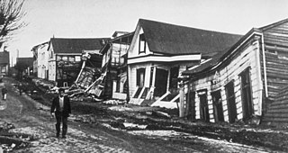
The 1770–1782 period was one of general drought in Central Chile with a total of three non-consecutive years of extreme drought. [1] In 1772 vineyards and cropfields along Mapocho River in Santiago could not be irrigated. [4] This drought led the authorities to begin the construction of the long-planned San Carlos Canal in 1772 to divert water from Maipo River to Mapocho River. [4]

Drought of 1924

In 1924 a drought spread between Coquimbo and Maule provinces. [5] In Coquimbo Province 70% of the wheat from non-irrigated land was lost while in irrigated areas the harvest loss was of 20%. [5] The price of railroad transport of livestock to places south of Curicó was lowered by 40% as there was hardly any grass or plant buds for livestock to eat in Norte Chico. [5]

Rural people in Coquimbo Region flocked around the towns of Illapel, Combarbalá and Ovalle. [4] Later the intendant of Coquimbo claimed that about hundred people had left the province as result of the drought. [5]

Great Drought of 1968

The drought faced by Chile between 1968, known as the Great Drought of 1968, was one of the largest rainfall deficits in the country during the twentieth century, comparable only to the drought of 1924. [6] The drought had its origin in the low amounts of precipitation that fell in 1967. [7] The area affected by the drought spanned from Atacama Province in the north to Ñuble in the south. [8]

The drought created huge losses for cultivations of potato, rice, maize, beans. Fruit trees and vineyards were also affected. [7] 100 thousand cattle and 1 million sheep died because of the drought. Milk, meat and wool output declined. [7] By September 1969 only 250 thousand goats remained from an earlier population of 650 thousand. [7]

Throughout rural Norte Chico, many farmers and communities came to lack water even for human consumption. [7] In 1969 farmers received support of several financial institutions and state agencies including tax exemptions and a line of credit to buy forage. [7]

In Central Chile, typical river flow increases in December, but this did not happen in 1968. [8] Chile many farmers decided to not cultivate in early summer due to this and to the known fact there was almost no snow in Andes. [8] Later in summer the rivers did grow due to glacier ablation, causing many farmers to repent albeit it was too late to cultivate. [8]

The decline in hydroelectric power generation (The hydroelectric deficit was of 200 MW) was partly compensated by having the thermoelectric plants of Ventanas, Renca and Laguna Verde function at maximum capacity. [7] National coal production from the Lota-Schwager mine was not enough to supply the need and the government authorized the import of 50 thousand tons of coal from the United States, Poland, France and Germany. [7]

In the hydrological year of 1969–1970 the area affected by the drought diminished from previously spanning the latitudes of 27–36° S to 27–32° S. [8]

Drought of 1998

Beginning in January 1997 the El Niño phenomenon affected Chile during 1 year until 1998. [9] Sea temperatures were high in the Pacific. [9]

The drought of 1998 caused an energy shortage in SIC, Chile's main power grid. [10] The energy shortage was worsened by problems in the Nehuenco Power Plant driven by natural gas. [10] Annual rainfall in Zona Sur was far below previous record lows: in Valdivia only 1,033.8 millimetres or 40.70 inches fell and in Concepción just 598.6 millimetres or 23.57 inches, [11] whereas the lowest before 1996 had been 674 millimetres (26.54 in) in 1924.

Chilean water crisis

Yeso reservoir March 14, 2020.jpg
El Yeso reservoir at 40% capacity in March 2020

The 1980 Constitution of Chile created under dictator Augusto Pinochet recognizes water as a private property and in 1981, his government rewrote laws regulating water, granting the sale and privatization of water in a manner similar to the stock market. [12] [13] The sale of water rights has been one of the primary factors that led to lower water levels in some areas. [12] [13] Chile began to experience a drought in 2010 and by 2020, precipitation was 20–45% of average nationally and 10–20% of average in the area of Santiago. [14] [12] By 2022, Chile was ranked 16th of 164 for water stress in the world according to the University of Chile. [15] In April 2022, Chile began a plan to ration water. [16]

Related Research Articles

<span class="mw-page-title-main">Santiago</span> Capital and largest city of Chile

Santiago, also known as Santiago de Chile, is the capital and largest city of Chile and one of the largest cities in the Americas. It is located in the country's central valley and is the center of the Santiago Metropolitan Region, which has a population of 7 million, representing 40% of Chile's total population. Most of the city is situated between 500–650 m (1,640–2,133 ft) above sea level.

<span class="mw-page-title-main">Pedro de Valdivia</span> Spanish conquistador

Pedro Gutiérrez de Valdivia or Valdiva was a Spanish conquistador and the first royal governor of Chile. After serving with the Spanish army in Italy and Flanders, he was sent to South America in 1534, where he served as lieutenant under Francisco Pizarro in Peru, acting as his second in command.

<span class="mw-page-title-main">1960 Valdivia earthquake</span> 9.4–9.6 magnitude earthquake in Chile

The 1960 Valdivia earthquake and tsunami or the Great Chilean earthquake on 22 May 1960 was the most powerful earthquake ever recorded. Various studies have placed it at 9.4–9.6 on the moment magnitude scale. It occurred in the afternoon, and lasted for approximately 10 minutes. The resulting tsunamis affected southern Chile, Hawaii, Japan, the Philippines, eastern New Zealand, southeast Australia, and the Aleutian Islands.

<span class="mw-page-title-main">Mapocho River</span> River in Chile

The River Mapocho is a river in Chile. It flows from its source in the Andes mountains onto the west and divides Chile's capital Santiago in two.

<span class="mw-page-title-main">Lo Barnechea</span> Commune in Chile

Lo Barnechea is a commune located in the northeastern sector of the province of Santiago and its area corresponds to 48% of this province. Its urban boundaries are: to the north with Los Andes of the Valparaíso region, to the west with Colina, to the southwest with Vitacura and Huechuraba, to the south with Las Condes and to the east with San José de Maipo. It developed around the old rural town of Lo Barnechea. Its population is heterogeneous, as it is inhabited by high- and medium-high-income families in sectors such as La Dehesa, Los Trapenses and El Arrayán, and also by medium-low- and low-income families, mainly in the towns of Lo Barnechea, Población La Ermita and Cerro Dieciocho.

<span class="mw-page-title-main">La Serena, Chile</span> City and Commune in Coquimbo, Chile

La Serena is a city and commune in northern Chile, capital of the Coquimbo Region. Founded in 1544, it is the country's second oldest city after the national capital, Santiago. As of 2012, it had a communal population of roughly 200,000, and was one of the fastest-growing areas of Chile.

<span class="mw-page-title-main">Maipo River</span> River in Chile

The Maipo River is the main river flowing through the Santiago Metropolitan Region and the Valparaíso Region of Chile. It is located just south of the capital of Santiago. The Mapocho River, which flows through central Santiago, is one of its tributaries. Its headwaters are on the west slope of Maipo volcano, in the Andes. The Maipo River is by far the major source of irrigation and potable water for the region.

<span class="mw-page-title-main">Agriculture in Chile</span>

Agriculture in Chile encompasses a wide range of different activities due to its particular geography, climate, geology and human factors. Historically agriculture is one of the bases of Chile's economy, now agriculture and allied sectors—like forestry, logging and fishing—account only for 4.9% of the GDP as of 2007 and employed 13.6% of the country's labor force. Some major agricultural products of Chile include grapes, apples, onions, wheat, corn, oats, peaches, garlic, asparagus, beans, beef, poultry, wool, fish and timber. Due to its geographical isolation and strict customs policies, Chile is free from diseases such as Mad Cow, fruit fly and Phylloxera, this plus being located in the southern hemisphere and its wide range of agriculture conditions are considered Chile's main comparative advantages. However, the mountainous landscape of Chile limits the extent and intensity of agriculture so that arable land corresponds only to 2.62% of the total territory.

Water Resources Management (WRM) in Chile is widely known for its 1981 Water Code—written after General Augusto Pinochet took control through a military coup d'état. Free-market mechanisms became the economic philosophy in WRM, including the development of water markets and tradable water permits. A major reform to the 1981 Water Code was signed in 2005 to address social equity and environmental protection concerns. Water resources management in Chile is shared among the private sector which provides investment for infrastructure and distribution, and agencies provide regulatory oversight, maintain records, and issue water rights. Chile is negotiating formalized agreements with both Bolivia and Argentina to manage shared resources and water storage projects. Chile is also supported in rural water supply with $150 million in loans by the World Bank and the Inter-American Development Bank.

<span class="mw-page-title-main">Ambrosio de Benavides</span> Spanish colonial governor

Ambrosio de Benavides Medina Liñán y Torres was a Spanish colonial administrator who served as Royal Governor of Puerto Rico, Royal Governor of Charcas and Royal Governor of Chile.

The 1985 Rapel Lake earthquake occurred on 8 April at 21:56:59 local time with a moment magnitude of 7.2 and a maximum perceived intensity of VI (Strong). The shock was centered 75 kilometres (47 mi) southwest of Santiago, Chile, with a focal depth of 37.8 km (23 mi).

<span class="mw-page-title-main">La Vega Central Market</span>

La Vega Central, also known as the Feria Mapocho, is a market located at the far south of Recoleta commune in Santiago de Chile, almost at the north bank of the Mapocho River. A wide variety of products are sold in its surrounds, principally fresh fruit and vegetables from the Chilean Central Valley. La Vega Central is also home to over 500 dairy, meat, goods and merchandise stores, and offers a variety of Chilean cuisine. Today, hundreds of thousands of people pass daily through La Vega's 60,000 square meters of stalls. La Vega Central has now achieved iconic status in Chile's capital. A long-time vendor at the market was quoted as saying, “Markets nowadays compete by using marketing, but La Vega has never had to resort to this. It subsists on its own creation and that is its magic.”

<span class="mw-page-title-main">Incas in Central Chile</span>

Inca rule in Chile was brief, it lasted from the 1470s to the 1530s when the Inca Empire was absorbed by Spain. The main settlements of the Inca Empire in Chile lay along the Aconcagua, Mapocho and Maipo rivers. Quillota in Aconcagua Valley was likely the Incas' foremost settlement. The bulk of the people conquered by the Incas in Central Chile were Diaguitas and part of the Promaucae. Incas appear to have distinguished between a "province of Chile" and a "province of Copayapo" neighboring it to the north. In Aconcagua Valley the Incas settled people from the areas of Arequipa and possibly also the Lake Titicaca.

<span class="mw-page-title-main">Mónica Echeverría</span> Chilean journalist (1920–2020)

Monica Echeverría Yáñez was a Chilean journalist, writer, actress and a Literature professor. She defined herself as a feminist since "before people called it that" and called herself a "rebel" and "anarchist" in the face of the neoliberal economic course of the Chilean government.

<span class="mw-page-title-main">2019–2022 Chilean protests</span> Civil unrest

A series of massive demonstrations and severe riots, known in Chile as the Estallido Social, originated in Santiago and took place in all regions of Chile, with a greater impact in the regional capitals. The protests mainly occurred between October 2019 and March 2020, in response to a raise in the Santiago Metro's subway fare, a probity crisis, cost of living, university graduate unemployment, privatisation, and inequality prevalent in the country.

The 2022 Chilean Primera División, known as Campeonato PlanVital 2022 for sponsorship purposes, is the 92nd season of the Chilean Primera División, Chile's top-flight football league. The season began on 4 February 2022 and ended on 6 November 2022.

<span class="mw-page-title-main">Chilean water crisis</span>

The Chilean water crisis is a period of extreme water scarcity and drought in Chile that began in 2010 in response to climate change, agricultural practices and the existing policies established in the early 1980s. It is the longest lasting drought experienced in Chile in over 700 to 1,000 years.

René Alfonso Morales Tame, known as Alfonso Morales and more popularly as Pocho Morales, was a Chilean football player who played as a centre-back.

References

  1. 1 2 3 Astaburuaga G., Ricardo (2004), "El agua en las zonas áridas de Chile", ARQ (in Spanish), 57: 68–73
  2. Villalba, Ricardo (1994), "Fluctuaciones climáticas en latitudes medias de América del Sur durante los últimos 1000 años: sus relaciones con la Oscilación del Sur" (PDF), Revista Chilena de Historia Natural (in Spanish), 67: 453–561
  3. "La megasequía 2010-2019: una lección para el futuro". Center for Climate and Resilience Research (in Spanish). Retrieved 2022-10-31.
  4. 1 2 3 Urrutia & Lanza 1993, pp. 67-68.
  5. 1 2 3 4 Urrutia & Lanza 1993, pp. 201-203.
  6. Espíldora, Basilio (1972), "Algunos antecedentes hidrológicos de la sequía en Chile" (PDF), Acta del Seminario Regional sobre Hidrología de Sequías, pp. 181–184, retrieved 2011-02-14
  7. 1 2 3 4 5 6 7 8 Urrutia & Lanza 1993, pp. 337-340.
  8. 1 2 3 4 5 Lobo, Eugenio (1972), "HIDROLOGIA DE SEQUIA EN CHILE" (PDF), ACTAS DEL SEMINARIO REGIONAL SOBRE HIDROLOGIA DE SEQUIAS (Lima, 21-27 de julio de 1970) (in Spanish): 226–229
  9. 1 2 Puentes, Edgardo, El Niño y la Niña (in Spanish), retrieved July 30, 2013
  10. 1 2 Crisis de Chile (1998-1999) (in Spanish), retrieved July 30, 2013
  11. "'Estadistica Climatologia II'" (PDF). Archived from the original (PDF) on 2012-04-17. Retrieved 2016-08-21.
  12. 1 2 3 "'Consequences will be dire': Chile's water crisis is reaching breaking point". The Guardian . 2022-06-01. Retrieved 2022-06-08.
  13. 1 2 "The mystery of a disappearing lake and the struggle over water rights in Chile | DW | 08.03.2022". Deutsche Welle . Retrieved 2022-06-08.
  14. "A Strained Water System in Chile". NASA . 2020-04-14. Retrieved 2022-06-08.
  15. "La crisis del agua". Interferencia (in Spanish). 2022-05-02. Retrieved 2022-06-08.
  16. "Chile announces unprecedented plan to ration water as drought enters 13th year". Reuters in Santiago, via The Guardian . 2022-04-11. Retrieved 2022-06-08.

Bibliography