
The Falkland Islands are located in the South Atlantic Ocean between 51°S and 53°S on a projection of the Patagonian Shelf, part of the South American continental shelf. In ancient geological time this shelf was part of Gondwana, and around 400 million years ago split from what is now Africa and drifted westwards from it. Today the islands are subjected to the Roaring Forties, winds that shape both their geography and climate.

South Georgia and the South Sandwich Islands (SGSSI) is a British Overseas Territory in the southern Atlantic Ocean. It is a remote and inhospitable collection of islands, consisting of South Georgia and a chain of smaller islands known as the South Sandwich Islands. South Georgia is 165 km (103 mi) long and 35 km (22 mi) wide and is by far the largest island in the territory. The South Sandwich Islands lie about 700 km (430 mi) southeast of South Georgia. The territory's total land area is 3,903 km2 (1,507 sq mi). The Falkland Islands are about 1,300 km (810 mi) north-west from its nearest point.

Weddell Island is one of the Falkland Islands in the South Atlantic, lying off the southwest extremity of West Falkland. It is situated 1,545 km (960 mi) west-northwest of South Georgia Island, 1,165 km (724 mi) north of Livingston Island, 606 km (377 mi) northeast of Cape Horn, 358 km (222 mi) northeast of Isla de los Estados, and 510 km (320 mi) east of the Atlantic entrance to Magellan Strait.

Lively Island is the largest of the Lively Island Group of the Falkland Islands, The island group lies east of East Falkland. Lively Island is the largest rat-free island in the Falklands, hence its importance to birdlife. The island also has a sheep farm.

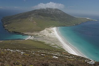
Carcass Island is the largest of the West Point Island Group of the Falkland Islands.
Saunders Island is the fourth largest of the Falkland Islands, lying north west of West Falkland. The island is run as a sheep farm.

The Jason Islands are an archipelago in the Falkland Islands, lying to the far north-west of West Falkland. Three of the islands, Steeple Jason, Grand Jason and Clarke's Islet, are private nature reserves owned by the Wildlife Conservation Society of New York City. Other islands in the group are National Nature Reserves owned by the Falkland Islands Government.

Pebble Island is one of the Falkland Islands, lying north of West Falkland. It is probably named after the peculiarly spherical pebbles found at its western tip.

West Point Island is one of the Falkland Islands, lying in the north-west corner of the archipelago. It has an area of 1,469 hectares (5.67 sq mi) and boasts some of the most spectacular coastal scenery in the Falklands. The island is owned by Roddy & Lily Napier and run as a sheep farm and tourist attraction.
Norsel Point is a rocky point on the north-west side of Arthur Harbour, on the western end of Amsler Island in the Palmer Archipelago of Antarctica.

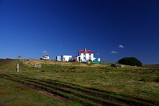
Port Egmont was the first British settlement in the Falkland Islands, on Saunders Island off West Falkland, and is named after the Earl of Egmont.

Hill Cove is the third largest settlement on West Falkland, in the Falkland Islands, in the north-west. It is on the north coast, on the shore of Byron Sound, and overlooks Port Egmont on Saunders Island, the first British settlement in the islands. Behind the settlement is Mount Adam, which shelters it from southerly winds.
Volunteer Point is a headland on the east coast of East Falkland, in the Falkland Islands, north-northeast of Stanley, and east of Johnson's Harbour and Berkeley Sound.

Mount Kent is a mountain on East Falkland, Falkland Islands, It is north of Mount Challenger and saw action in the Falklands War during the Battle of Mount Harriet – some of the area is still mined. The mountain's top is occupied by the RRH Mount Kent of the British Forces South Atlantic Islands (BFSAI), part of an early warning and airspace control network including also RRH Mount Alice and RRH Byron Heights on West Falkland.

Hummock Island is the largest of a group of islands in King George Bay in the Falkland Islands. It has a land area of 3.03 square kilometres (1.17 sq mi) and is about 4.0 miles (6.4 km) long in a north-west to south-east direction. Hummock Island is off the western coast of West Falkland, in a bay that leads to the estuary of the Chartres River. The highest point on the island is in the north-east and is 190 metres (620 ft). There are cliffs which often reach over 60 metres (200 ft) high.

Race Point is the point on the north side of Smylie Channel forming the south extremity of Weddell Island in the Falkland Islands. The point is located at 51°59′22″S61°00′00″W, which is 26.7 km south-southwest of Swan Point, 3.5 km west-northwest of neighbouring Dyke Island, 1.8 km north of West Island and 4 km north-northeast of Orford Hill, West Falkland.
Hope Harbour is an inlet at the north-west of West Falkland in the Falkland Islands of the South Atlantic Ocean. About 4 km long and 1.3 km wide, it is sheltered by the promontory of Grave Cove Camp in the south, a narrow ridge terminating in Hope Point to the north, Bramble Point Camp to the east, and West Point Island at its entrance to the west. Carcass Island lies 8 km north-east of Hope Point.

Mount Alice is a mountain rising to 361 m (1,180 ft) at the south extremity of West Falkland, Falkland Islands in the South Atlantic. It is situated between the bays of Port Stephens and Port Albemarle, 12.3 km (7.6 mi) due north of Cape Meredith.
Byron Heights is a mountain rising to 497 m (1,630 ft) at the northwest extremity of West Falkland, Falkland Islands in the South Atlantic. It is situated 11.65 km (7.24 mi) southeast of Hope Point.


