Dundry

Last updated

Dundry
Dundry-fairlawns.JPG
Dundry church
Somerset UK location map.svg
Red pog.svg
Dundry
Location within Somerset
Population829  [1]
OS grid reference ST555665
Unitary authority
Ceremonial county
Region
Country England
Sovereign state United Kingdom
Post town BRISTOL
Postcode district BS41
Dialling code 0117
Police Avon and Somerset
Fire Avon
Ambulance South Western
UK Parliament
List of places
UK
England
Somerset
51°23′45″N2°38′20″W / 51.3957°N 2.6389°W / 51.3957; -2.6389
The western part of Dundry village seen from the top of the church tower in 2004 View of Dundry taken from the church tower 04.JPG
The western part of Dundry village seen from the top of the church tower in 2004
The west part of East Dundry in 1962 East Dundry 1962.jpg
The west part of East Dundry in 1962
The East Dundry baby nearly bombed during his 24 November 1940 Christening in Bristol StJamesPresbyterianCofEBristoldaybombed.jpg
The East Dundry baby nearly bombed during his 24 November 1940 Christening in Bristol

Dundry is a village and civil parish, situated on Dundry Hill in the northern part of the Mendip Hills, between Bristol and the Chew Valley Lake, in the English county of North Somerset, previously Somerset. The parish includes the hamlets of Maiden Head and East Dundry. The parish had a 2011 population of 829. [1]

Contents

The village lies on the route of the Monarch's Way long-distance footpath. It is a popular destination for the people of Bristol as it is known for its panoramic views of the city.

History

According to Robinson the name means 'The hill that is dry' from the Old English dun and dryge. [2] An alternative derivation is from a Celtic name, meaning fort of refuge. [3]

The parish was part of the hundred of Chew. [4]

Dundry is notable for its stone: the yellow oolitic limestone from local quarries such as Dundry Main Road, South Quarry and the Dundry Downs (to the west of the village) is found even at Cardiff Castle, a fort originally built by the Romans to defend against Anglo-Saxon invasions. The stone was much used in medieval Bristol: an outstanding example being St Mary Redcliffe, an Anglican church in central Bristol. Dundry stone was extensively important in Ireland after the 12th century Anglo-Norman invasions, being used to build Christ Church Cathedral, Dublin, amongst many other prominent buildings. [5] [6] A large cube of stone (approximately 1.5m each edge) still stands in the churchyard: the cube is much considered to be an early advertisement for Dundry stone.

The neighbouring village of Chew Magna has in its graveyard an early 19th-century limestone round-topped stone which bears the inscription to William Fowler "shot by an Highwayman on Dundry Hill 14 June 1814 aged 32 years". [7]

Second World War

Being so close to Bristol, Dundry caught many of the 77 air raids (mostly in 1940 and 1941) for which Bristol had:

Many bombs and anti-aircraft shells landed in Dundry. The diary [9] of Doris Ogilvie of East Dundry records that:

Dundry Home Guard

During World War II members of the Dundry Home Guard had many draughty nights on the top of the church, on Maes Knoll, and (on Dundry Down) at the wireless complex watching out for air raids and possible troop landings by parachute and glider. Captain Knight of Walnut Farm, East Dundry served in the First World War and was in charge of the Dundry Home Guard. Fire watchers turned out to watch for fires whenever there were bombing raids.

500 metres south of Rackledown Farm in East Dundry, there was a Civil Bombing QL decoy site, C1C. It was built as part of the 'C-series' of civil decoys. This QL site operated from the same operations room as a permanent Starfish site SF1B that was located 800 metres further south. These sites featured displays of muted lights to appear like urban areas during poor blackouts. Bonfires were also lit to resemble buildings under attack with the intention of tricking the bombers to release the bomb load before arriving over Bristol. In 1941, there was a Home Guard exercise for Dundry and neighbouring villages including Winford, Bishopsworth, Leigh Woods and Norton Malreward. [9]

1968 storm

On 10 July 1968 a storm deluged the parish and neighbouring areas—172 mm (6.8 in) of rain was measured in Chew Stoke, [11] and local streams such as Winford Brook were swollen by rain running off the slopes of Dundry Hill. [11]

Governance

The parish council has responsibility for local issues, including setting an annual precept (local rate) to cover the council's operating costs and producing annual accounts for public scrutiny. The parish council evaluates local planning applications and works with the local police, district council officers, and neighbourhood watch groups on matters of crime, security, and traffic. The parish council's role also includes initiating projects for the maintenance and repair of parish facilities, such as the village hall or community centre, playing fields and playgrounds, as well as consulting with the district council on the maintenance, repair, and improvement of highways, drainage, footpaths, public transport, and street cleaning. Conservation matters (including trees and listed buildings) and environmental issues are also of interest to the council.

The parish is in the unitary authority of North Somerset which was created in 1996, as established by the Local Government Act 1992. This act established a single tier of local government with responsibility for almost all local government functions within its area including local planning and building control, local roads, council housing, environmental health, markets and fairs, refuse collection, recycling, cemeteries, crematoria, leisure services, parks, and tourism. It is also responsible for education, social services, libraries, main roads, public transport, trading standards, waste disposal and strategic planning, although fire, police and ambulance services are provided jointly with other authorities through the Avon Fire and Rescue Service, Avon and Somerset Constabulary and the South Western Ambulance Service.

North Somerset's area covers part of the ceremonial county of Somerset but it is administered independently of the non-metropolitan county. Its administrative headquarters is in the town hall in Weston-super-Mare. Between 1 April 1974 and 1 April 1996, it was the Woodspring district of the county of Avon. [12] Before 1974 that the parish was part of the Long Ashton Rural District. [13]

The parish is represented in the House of Commons of the Parliament of the United Kingdom as part of the North Somerset constituency. It elects one Member of Parliament (MP) by the first past the post system of election, currently Liam Fox of the Conservative Party. It was also part of the South West England constituency of the European Parliament prior to Britain leaving the European Union in January 2020, which elected seven MEPs using the d'Hondt method of party-list proportional representation.

Religious sites

The Church of St Michael at Dundry [14] is a prominent feature in its hill-top position with its tower visible for many miles around. The four-stage tower [15] was erected by the Society of Merchant Venturers of Bristol as a landmark and is widely visible. [16]

Transport

In the 1940s and 1950s the Ball family of Dundry ran the "Dundry Pioneer" bus service from Dundry Chapel via Dundry Church and the Hairpin Corner into Prince Street in central Bristol with Bedford buses. After the Dundry Pioneer, Bristol buses route 80, renumbered 373 in 1983, served Dundry.

Notable persons

Lawrence Ogilvie (1898–1980), East Dundry, plant pathologist

Related Research Articles

<span class="mw-page-title-main">Bath and North East Somerset</span> District in England

Bath and North East Somerset (B&NES) is a unitary authority district in Somerset, South West England. Bath and North East Somerset Council was created on 1 April 1996 following the abolition of the county of Avon. It is part of the ceremonial county of Somerset.

<span class="mw-page-title-main">Chew Magna</span> Village in Somerset, England

Chew Magna is a village and civil parish within the Chew Valley in the unitary authority of Bath and North East Somerset, in the ceremonial county of Somerset, England. The parish has a population of 1,149.

<span class="mw-page-title-main">Chew Stoke</span> Village and civil parish in Somerset, England

Chew Stoke is a small village and civil parish in the affluent Chew Valley, in Somerset, England, about 8 miles (13 km) south of Bristol and 10 miles north of Wells. It is at the northern edge of the Mendip Hills, a region designated by the United Kingdom as an Area of Outstanding Natural Beauty, and is within the Bristol and Bath green belt. The parish includes the hamlet of Breach Hill, which is approximately 2 miles (3.2 km) southwest of Chew Stoke itself.

<span class="mw-page-title-main">Pensford</span> Human settlement in England

Pensford is the largest village in the civil parish of Publow in Somerset, England. It lies in the Chew Valley, approximately 7 miles (11 km) south of Bristol, 8 miles (13 km) west of Bath, and 14 miles (23 km) north of Wells. It is on the A37 road from Bristol to Shepton Mallet.

<span class="mw-page-title-main">Monarch's Way</span> Long-distance footpath in England

The Monarch's Way is a 625-mile (1,006 km) long-distance footpath in England that approximates the escape route taken by King Charles II in 1651 after being defeated in the Battle of Worcester. It runs from Worcester via Bristol and Yeovil to Shoreham, West Sussex.

<span class="mw-page-title-main">Bishop Sutton</span> Human settlement in England

Bishop Sutton is a village on the northern slopes of the Mendip Hills, within the affluent Chew Valley in Somerset. It lies east of Chew Valley Lake and north east of the Mendip Hills, approximately ten miles south of Bristol on the A368, Weston-super-Mare to Bath road between West Harptree and Chelwood. Bishop Sutton and the neighbouring village of Stowey form the civil parish of Stowey Sutton.

<span class="mw-page-title-main">Winford</span> Human settlement in England

Winford is a village and civil parish within the Chew Valley, Somerset, England. It is within the unitary authority of North Somerset about 8 miles (12.9 km) south of Bristol. The parish has a population of 2,153.

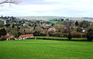
The Chew Valley is an affluent area in North Somerset, England, named after the River Chew, which rises at Chewton Mendip, and joins the River Avon at Keynsham. Technically, the area of the valley is bounded by the water catchment area of the Chew and its tributaries; however, the name Chew Valley is often used less formally to cover other nearby areas, for example, Blagdon Lake and its environs, which by a stricter definition are part of the Yeo Valley. The valley is an area of rich arable and dairy farmland, interspersed with a number of villages.

<span class="mw-page-title-main">Ubley</span> Human settlement in England

Ubley is a small village and civil parish within the Chew Valley in Bath and North East Somerset about 9 miles (14.5 km) south of Bristol. It is just south-east of Blagdon Lake, just off the A368 between Compton Martin and Blagdon.

<span class="mw-page-title-main">Norton Malreward</span> Village and civil parish in Somerset, England

Norton Malreward is a small Somerset village and civil parish 4 miles (6.4 km) south of Bristol, England at the northern edge of the Chew Valley. In 1895 Norton Malreward was combined with the neighbouring hamlet of Norton Hawkfield into a single parish, which has a population of 246.

<span class="mw-page-title-main">Publow</span> Human settlement in England

Publow is a small village and civil parish in Bath and North East Somerset, England. It lies beside the River Chew in the Chew Valley. It is 7 miles from Bristol, 9 miles from Bath, and 4 miles from Keynsham. The principal settlement in the parish is Pensford. The parish also includes the village of Belluton and part of the village of Woollard. At the 2011 census it had a population of 1,119.

<span class="mw-page-title-main">Stowey</span> Human settlement in England

Stowey is a small village and former civil parish, now in the parish of Stowey Sutton, in the Bath and North East Somerset district, in the ceremonial county of Somerset, England. It lies within the Chew Valley, south of Chew Valley Lake and north of the Mendip Hills, approximately 10 miles (16 km) south of Bristol on the A368 road Weston-super-Mare to Bath. Stowey and its neighbouring and larger village, Bishop Sutton, form the civil parish of Stowey Sutton.

<span class="mw-page-title-main">Bishopsworth</span> Human settlement in England

Bishopsworth is the name of both a council ward of the city of Bristol in the United Kingdom, and a suburb of the city which lies within that ward. Bishopsworth contains many council estates.

<span class="mw-page-title-main">East Dundry</span> Human settlement in England

East Dundry is a south-facing hamlet some 160 metres above sea level in a sheltered valley of Dundry Hill just south of Bristol, England. The hamlet is in the parish of Dundry and about two kilometres east of its village church. The iron-age Maes Knoll tump and tumuli are evidence of long occupation of the valley.

<span class="mw-page-title-main">Stanton Drew</span> Human settlement in England

Stanton Drew is a small village and civil parish within the Chew Valley in Somerset, England, lying north of the Mendip Hills, 8 miles (13 km) south of Bristol in the area of the Bath and North East Somerset unitary authority.

<span class="mw-page-title-main">Bristol Blitz</span> WWII aerial bombardment of British city

The Bristol Blitz was the heavy bombing of Bristol, England by the Nazi German Luftwaffe during the Second World War. Due to the presence of Bristol Harbour and the Bristol Aeroplane Company, the city was a target for bombing and was easily found as enemy bombers were able to trace a course up the River Avon from Avonmouth using reflected moonlight on the waters, into the heart of the city. Bristol was the fifth-most heavily-bombed British city of the war.

<span class="mw-page-title-main">Corston, Somerset</span> Human settlement in England

Corston is a small village and civil parish close to the River Avon and situated on the A39 road in the Bath and North East Somerset unitary authority, Somerset, England. The parish has a population of 494.

<span class="mw-page-title-main">St Michael's Church, Dundry</span> Church in Somerset, England

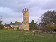
The parish church of St Michael the Archangel in Dundry, Somerset, England has a tower which was built in 1484, with the rest dated 1861. It has been designated as a Grade I listed building.

<span class="mw-page-title-main">St Andrew's Church, Chew Magna</span> Church in Somerset, England

The Church of St Andrew in Chew Magna, Somerset, England dates from the 12th century with a large 15th-century pinnacled sandstone tower, a Norman font and a rood screen that is the full width of the church. It is a Grade I listed building.

References

  1. 1 2 "2011 Census Profile". North Somerset Council. Archived from the original (Excel) on 4 January 2014. Retrieved 4 January 2014.
  2. Robinson, Stephen (1992). Somerset Place Names. Wimborne, Dorset: The Dovecote Press Ltd. ISBN   1-874336-03-2.
  3. "Maes Knoll Iron Age camp". Wansdyke Project 21. Retrieved 25 July 2010.
  4. "Somerset Hundreds". GENUKI. Retrieved 8 October 2011.
  5. Waterman, D. M. (1970). "Somersetshire and Other Foreign Building Stone in Medieval Ireland, c. 1175-1400". Ulster Journal of Archaeology. 33: 63–75. JSTOR   20567668.
  6. "Dundry Stone".
  7. "Rising Main and Sewage Pumping Station, Chew Magna, North East Somerset. Phase 1: Trial pits and boreholes. An Archaeological Watching Brief" (PDF). ContextOne. Archived from the original (PDF) on 20 August 2007. Retrieved 19 September 2007.
  8. Blitz over Britain by Edwin Webb and John Duncan 1990, page 90
  9. 1 2 Bristol Record Office accession 44394
  10. Blitz over Britain by Edwin Webb and John Duncan 1990, page 86
  11. 1 2 "Learning the lessons — The Chew Valley floods of 1968" (PDF). Environment Agency. Archived from the original (PDF) on 16 July 2011. Retrieved 24 June 2010.
  12. "The Avon (Structural Change) Order 1995". HMSO. Archived from the original on 30 January 2008. Retrieved 9 December 2007.
  13. "Long Ashton RD". A vision of Britain Through Time. University of Portsmouth. Retrieved 4 January 2014.
  14. Pages 74-78 of Volume 2 of West Country Churches by W J Robinson, published 1914 by Bristol Times and Mirror Limited.
  15. Scott, Shane (1995). The hidden places of Somerset. Aldermaston: Travel Publishing Ltd. p. 36. ISBN   1-902007-01-8.
  16. "Church of St Michael, Dundry". historicengland.org.uk. Retrieved 13 October 2007.