U.S. Route 91 or U.S. Highway 91 (US-91) is a 172.663-mile-long (277.874 km) north–south United States highway running from Brigham City, Utah to Idaho Falls, Idaho in the U.S. states of Idaho and Utah. Despite the "1" as the last digit in the number, US-91 is no longer a cross country artery. The highway currently serves to connect the communities of the Cache Valley to Interstate 15 and beyond. Prior to the mid-1970s, US 91 was an international commerce route from Long Beach, California to the Canada–US border north of Sweetgrass, Montana. US 91 was routed on the main streets of most of the communities it served, including Las Vegas Boulevard in Las Vegas and State Street in Salt Lake City. From Los Angeles to Salt Lake, the route was built along the corridor of the Arrowhead Trail. US 91 has been largely replaced by Interstate 15. A portion of the highway's former route in California is currently State Route 91.
Interstate 515 (I-515) is a 14.444-mile-long (23.245 km) spur route of Interstate 15 in Nevada that runs from the junction of I-11, I-215 and SR 564 in Henderson to the junction of I-15, US 93 and US 95 in Downtown Las Vegas. The freeway connects traffic headed from Boulder City and Henderson to Downtown Las Vegas via a direct, high-speed route and is concurrent with both US 93 and US 95 along its entire length.

Summerlin is an affluent master-planned community in the Las Vegas Valley of Southern Nevada. It lies at the edge of the Spring Mountains and Red Rock Canyon to the west; it is partly within the official city limits of Las Vegas and partly within unincorporated Clark County. This rapidly growing community occupies over 22,500 acres and according to its developers, "has grown to encompass more than 230 parks, more than two dozen public and private schools, 14 houses of worship, nine golf courses, three resort hotels, recreational facilities, retail and entertainment centers, well-established office parks, a medical center, and more."

The Las Vegas Valley is a major metropolitan area in the southern part of the U.S. state of Nevada. The state's largest urban agglomeration, the Las Vegas Metropolitan Statistical Area is coextensive since 2003 with Clark County, Nevada. The Valley is largely defined by the Las Vegas Valley landform, a 600 sq mi (1,600 km2) basin area surrounded by mountains to the north, south, east and west of the metropolitan area. The Valley is home to the three largest incorporated cities in Nevada: Las Vegas, Henderson and North Las Vegas. Eleven unincorporated towns governed by the Clark County government are part of the Las Vegas Township and constitute the largest community in the state of Nevada.
The Las Vegas Beltway is a 50.3-mile (81.0 km) beltway route circling three-quarters of the Las Vegas Valley in southern Nevada. The Las Vegas Beltway carries two numerical designations. Approximately 11.1 miles (17.9 km) of the highway, from its southern terminus at Interstate 11/Interstate 515/U.S. Route 93/U.S. Route 95 in Henderson west and northwest to Interstate 15, is signed as Interstate 215 (I-215); however, only two distinct portions of this section, totaling a little over 4.6 miles (7.4 km), are maintained by the Nevada Department of Transportation. Clark County Route 215 composes the remaining 39.2 miles (63.1 km) of this semi-circumferral highway, with the county's Department of Public Works responsible for all construction and maintenance.
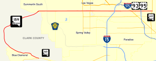
State Route 159 is a 31.204-mile (50.218 km) east–west highway in Clark County, Nevada, United States, providing access to Red Rock Canyon and serving as a thoroughfare in the Las Vegas metropolitan area. A portion of the west end of the route is designated a Nevada Scenic Byway.
State Route 595 comprises a portion of Rainbow Boulevard, a north–south section line arterial in the Las Vegas Valley.
State Road 865 and County Road 865 are a series of roads serving Lee County, Florida. Originally a continuous state road extending from Bonita Springs to Tice by way of Fort Myers Beach and Fort Myers, SR 865 now consists of two segments connected by a part of CR 865, which also extends to the north and south of the state segments. Both the state and county controlled segments of the route combined stretch a distance of over 40 miles (64.37 km), making it the longest designation in Lee County.
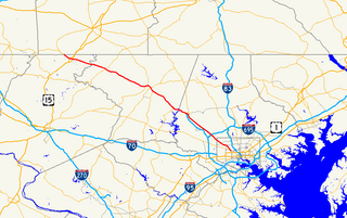
Route 15, consisting of the contiguous segments of State Route 15 and Interstate 15 (I-15), is a major north–south state highway and Interstate Highway in the U.S. state of California, connecting San Bernardino, Riverside, and San Diego Counties. The route consists of the southernmost 289.24 miles (465.49 km) of I-15, which extends north through Nevada, Arizona, Utah, Idaho, and Montana to the Canada–US border. It is a major thoroughfare for traffic between San Diego and the Inland Empire, as well as between Southern California, Las Vegas, Nevada, and the Intermountain West.
Spring Mountain Road is a major east-west road in the Las Vegas Valley. It runs from Hualapai Way at its western terminus to Las Vegas Boulevard in the east. East of Las Vegas Boulevard, Spring Mountain becomes Sands Avenue, and then jogs south to join Twain Avenue. State Route 591 was a state highway that comprised a 0.242-mile (0.389 km) section of Spring Mountain at Interstate 15.
Maryland Route 140 is a 49-mile (79 km) state highway in the U.S. state of Maryland. The route runs from U.S. Route 1 and US 40 Truck in Baltimore northwest to the Pennsylvania border, where the road continues into that state as Pennsylvania Route 16. MD 140 passes through the northern part of central Maryland, connecting Baltimore, Pikesville, Reisterstown, Westminster, Taneytown, and Emmitsburg.
U.S. Route 40 in the U.S. state of Maryland runs from Garrett County in Western Maryland to Cecil County in the state's northeastern corner. With a total length of 221 miles (356 km), it is the longest numbered highway in Maryland. Almost half of the road overlaps or parallels with Interstate 68 (I-68) or I-70, while the old alignment is generally known as US 40 Alternate, US 40 Scenic, or Maryland Route 144. West of Baltimore, in the Piedmont and Appalachian Mountains / Blue Ridge region of the Western Maryland panhandle of the small state, the portions where it does not overlap an Interstate highway are mostly two-lane roads. The portion northeast of Baltimore going toward Wilmington in northern Delaware and Philadelphia in southeastern Pennsylvania is a four-lane divided highway, known as the Pulaski Highway. This section crosses the Susquehanna River at the north end of the Chesapeake Bay on the Thomas J. Hatem Memorial Bridge.

U.S. Route 95 is a major U.S. highway traversing the U.S. state of Nevada from north to south directly through Las Vegas and providing connections to both Carson City and Reno. US 95 is cosigned with Interstate 80 for 95 miles (153 km) between a junction in Trinity and Winnemucca before heading north into Oregon at McDermitt. At 646 miles, it is the longest highway in Nevada.
State Route 613, better known as Summerlin Parkway, is a freeway in the western portion of the city of Las Vegas, Nevada, connecting Clark County Route 215 to U.S. Route 95 and serving the master planned community of Summerlin.
Desert Inn Road, also known as Wilbur Clark D. I. Road, is a major west-east road in the Las Vegas metropolitan area, Nevada, United States, part of the Las Vegas grid road system. It is named after the former Desert Inn hotel and casino.
Elkhorn Road is a major west-east road in the Las Vegas metropolitan area, Nevada, United States.
The Centennial Bowl is the colloquial name for an under-construction freeway interchange in Las Vegas, in the U.S. state of Nevada, in the Centennial Hills suburb. It currently serves U.S. Route 95 (US 95) and Clark County Route 215 and two US 95 frontage roads; Oso Blanca Road and Sky Pointe Drive. After completion of the interchange in 2024, CC 215 will be upgraded to freeway standards from its southern terminus at the Henderson Bowl to Range Road in North Las Vegas at the northern terminus interchange construction, and Interstate 11 (I-11) will follow the route of US 95 from its current northern terminus at the Henderson Bowl to State Route 157.
