E-ZPass Minnesota

Last updated

E-ZPass Minnesota, formerly MnPass, is the brand name associated with a series of high occupancy toll lanes (HO/T lanes) and electronic toll collection (ETC) system in the Minneapolis-St. Paul Metropolitan Area of Minnesota. The lanes and the ETC system are owned by the Minnesota Department of Transportation (MnDOT) and fully compatible with the multi-state E-ZPass network.

Contents

Solo drivers who are registered under the E-ZPass program and have a toll transponder are allowed to pay a toll to use the lanes during operating hours. Vehicles with two or more occupants, buses, and motorcycles may use the lanes for free without requiring a toll transponder.

Transponders

The primary device is a switchable tag. The switchable tag allows users to switch between HOV mode (where using the lanes is free) and solo mode (where users must pay the toll to use the lanes). The current transponder is a rebranded E-ZPass Flex tag which is also used in other states. [1]

A license plate tag is available for vehicles that have a metallic tint on their windshield that would prevent the E-ZPass equipment from reading the tag. There is a $15 one-time fee for the license plate tag, which otherwise functions the same as the sticker tag.

The initial minimum prepaid amount for a E-ZPass Minnesota account is $25, plus the cost of an transponder type if applicable. [1]

Small commercial vehicles that are no more than two axles and weigh less than 26,000 pounds (12,000 kg) are eligible to register for a E-ZPass account and transponder. Commercial vehicles with more than two axles or weigh more than 26,000 pounds (12,000 kg) are prohibited from having a transponder, but may still use the E-ZPass lanes when the lanes are free and open to all traffic. [2]

Until August 2, 2021, the MnPASS system was not interoperable with other transponder-based toll systems, such as E-ZPass, I-Pass, or FasTrak. [3] E-ZPass became interoperable with the MnPASS system starting on August 2, 2021, and MnPass was rebranded as E-ZPass Minnesota. Existing MnPASS holders are allowed to keep their tags or trade them for E-ZPass tags, and existing MnPASS transponders continue to function on Minnesota toll roads (but not on other states' toll roads). [4]

Before joining the E-ZPass system in 2021, a sticker tag was the default tag, and was provided for free. Existing sticker tag transponders are still valid in Minnesota but cannot be used outside of the state. Applied to the inside of the windshield it is not transferable and is always active.

Toll rates

During E-ZPass Minnesota operating hours, tolls for the E-ZPass lanes range from $0.25 to $8. The actual toll level depends on the volume of traffic. Higher volumes of traffic usually result in higher toll levels. Electronic sensors monitor the traffic density and tolls are changed every three minutes. The variable tolls are intended to keep traffic in the E-ZPass lanes moving between 50 and 55 miles per hour (80 and 89 km/h). [5] Outside of operating hours, there is no toll and the lanes are free (signed simply as "OPEN") and open to all traffic (regardless of whether they have a transponder or not) with one exception: the reversible E-ZPass lanes on Interstate 394 (I-394) between Minnesota State Highway 100 (MN 100) and I-94 always has a minimum $0.25 toll and thus are not open to solo drivers without a E-ZPass transponder.

I-394/U.S. Highway 12

I-394 heading eastbound toward downtown Minneapolis; notice the toll lane to the left. 394EastBound.jpg
I-394 heading eastbound toward downtown Minneapolis; notice the toll lane to the left.

The I-394 MnPASS lanes opened in May 2005 and were the first such lanes in Minnesota. The lanes were converted from the previous high-occupancy vehicle lanes that were constructed with I-394 in the 1980s and early 1990s.

West of the Xenia/Park Place interchange (just west of MN 100, the E-ZPass lanes function as concurrent flow [6] lanes, utilizing the inside/left lane in each direction. These lanes are separated from the general purpose lanes only by lane striping, as are the I-35W and I-35E E-ZPass lanes. The lane striping ranges from a single dashed white line where lane changes (and E-ZPass lane access) is allowed to double solid white lines where lane changing is prohibited. The westbound E-ZPass lane ends at the I-494 overpass (continuing west of I-494 as a general purpose lane), while the eastbound E-ZPass lane begins at the County Road 15 (CR 15) interchange on U.S. Highway 12 (US 12) in Wayzata. These concurrent flow E-ZPass lanes are tolled eastbound between 6 and 10 am weekdays and westbound between 3 and 7 pm weekdays. [7] They are open to all traffic at all other times.

East of the Xenia/Park Place interchange, the E-ZPass lanes transition to a pair of median-running reversible lanes that are physically separated from the general purpose lanes by a concrete barrier. These lanes extend to the edge of downtown Minneapolis before ending and merging into the I-394 mainline at I-94. Intermediate access to these reversible E-ZPass lane is limited to MN 100, the south frontage road at MN 100, Dunwoody Boulevard/Van White Boulevard, and I-94 in the direction of the Lowry Hill Tunnel. The lanes are open eastbound (towards downtown) from 6am to 1pm daily, and westbound (away from downtown) daily from 2pm to 5am the following morning. [7] Hours may vary due to special events or maintenance activities.

There were a total of over 1.3 million tolled trips taken in the I-394 MnPASS lanes in 2017. [7]

I-35W

The E-ZPass lanes along I-35W south of downtown Minneapolis were opened in stages between 2009 and 2011 and are a combination of new construction (south of Burnsville Parkway), conversion of the previously existing high-occupancy vehicle lanes (between Burnsville Parkway and 66th Street), construction related to the Crosstown Commons project, and conversion of a median shoulder into a priced dynamic shoulder lane. [8] The lanes are concurrent-flow lanes using the inside/left lane in each direction. The northbound E-ZPass lane begins at CR 42 and extends continuously to 26th Street. The southbound E-ZPass Lane begins at 26th Street and extends to Cliff Road. The northbound E-ZPass lane is tolled weekdays between 6 and 10 am and the segment north of MN 62 is also tolled between 3 and 7 pm. The southbound E-ZPass lane is tolled weekdays between 3 and 7 pm with the segment between 42nd Street and I-494 also tolled between 6 and 10 am. The lanes are open to all traffic at all other times.

E-ZPass lanes on I-35W between County Road C in Roseville and Lexington Avenue in Blaine were opened in 2021. [9]

Almost 950,000 tolled trips were taken in the I-35W MnPASS lanes in 2017. [7]

The Orange Line bus rapid transitway utilizes the I-35W MnPASS lanes. [10]

I-35E

The I-35E E-ZPass lanes are the first such lanes in the eastern half of the Minneapolis-St. Paul Metropolitan Area. These are concurrent-flow lanes, using the inside/left lane in each direction. The lanes were opened from Cayuga Street (north edge of downtown St. Paul) to Little Canada Road in December 2015 and were added as part of a full reconstruction project. In December 2016, the southbound E-ZPass lane was extended to begin at CR 96, while a separate northbound E-ZPass Lane was added between CR E (north of I-694) and CR J (at the RamseyAnoka county line. The two northbound E-ZPass lanes are tolled weekdays between 3 and 7 pm, while the southbound E-ZPass lane is tolled weekdays between 6 and 10 am. The lanes are open to all traffic at all other times.

Approximately 440,000 tolled trips were taken in the I-35E MnPASS lanes in 2017. [7]

I-494

The I-494 E-ZPass lanes are yet to be constructed, but will be constructed between 2021 and 2023. Westbound there will be a E-ZPass lane from MN 77 to I-35W, and eastbound from France Avenue to MN 77. The project is part of a major corridor study happening on I-494.

Future E-ZPass Minnesota lanes

MnDOT is currently studying the I-94 corridor between downtown Minneapolis and downtown St. Paul. No recommendations have come out of this study yet as of April 2018. However, the corridor is listed as a Tier 1 Corridor for E-ZPass implementation by the Metropolitan Council, the region's metropolitan planning organization. [11]

MnDOT is currently studying the US 169 corridor between MN 41 near Shakopee and MN 55 in Plymouth. E-ZPass lanes are one of the options being considered. [12]

Related Research Articles

<span class="mw-page-title-main">Interstate 35</span> Interstate Highway from Texas to Minnesota

Interstate 35 (I-35) is a major Interstate Highway in the central United States. As with most primary Interstates that end in a five, it is a major cross-country, north–south route. It stretches from Laredo, Texas, near the Mexican border to Duluth, Minnesota, at Minnesota State Highway 61 and 26th Avenue East. The highway splits into I-35E and I-35W in two separate places, the Dallas–Fort Worth metroplex in Texas and at the Minnesota twin cities of Minneapolis–Saint Paul.

<span class="mw-page-title-main">Interstate 94</span> Interstate Highway across the upper Midwestern US

Interstate 94 (I-94) is an east–west Interstate Highway connecting the Great Lakes and northern Great Plains regions of the United States. Its western terminus is just east of Billings, Montana, at a junction with I-90; its eastern terminus is in Port Huron, Michigan, where it meets with I-69 and crosses the Blue Water Bridge into Sarnia, Ontario, Canada, where the route becomes Ontario Highway 402. It thus lies along the primary overland route from Seattle to Toronto and is the only east–west Interstate Highway to have a direct connection to Canada.

E-ZPass is an electronic toll collection system used on toll roads, toll bridges, and toll tunnels in the Eastern United States, Midwestern United States, and Southern United States. The E-ZPass Interagency Group (IAG) consists of member agencies in several states, which use the same technology and allow travelers to use the same transponder on toll roads throughout the network.

<span class="mw-page-title-main">Interstate 494</span> Highway in Minnesota

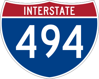
Interstate 494 (I-494) is an auxiliary Interstate Highway making up part of a beltway of I-94, circling through the southern and western portions of the Minneapolis–Saint Paul metropolitan area in Minnesota. The 42.94-mile (69.11 km) road is coupled with I-694 at each end and composes more than half of the major beltway of the region. I-694/I-494 also act as loop routes for I-35E and I-35W.

<span class="mw-page-title-main">California State Route 237</span> Highway in California

State Route 237 is a state highway in the U.S. state of California that runs from El Camino Real in Mountain View to Interstate 680 in Milpitas. Known as the Southbay Freeway for most of its length, SR 237 runs south of the San Francisco Bay, connecting the East Bay to the Peninsula.

<span class="mw-page-title-main">Interstate 694</span> Highway in Minnesota

Interstate 694 (I-694) is an east–west auxiliary Interstate Highway located in the Minneapolis–Saint Paul metropolitan area in the US state of Minnesota. The western terminus of the route is at its junction with I-94, I-494, and US Highway 52 (US 52) in Maple Grove. The eastern terminus of I-694 is at its junction with I-94 and I-494 at the Woodbury–Oakdale city line. I-694 comprises the northern and northeastern portions of a beltway around the Twin Cities, with I-494 forming the remainder of the beltway. The speed limit is 60 mph (97 km/h). Interstate Highways outside of the loop in Minnesota may be signed as high as 70 mph (110 km/h) but can only reach 60 mph (97 km/h) inside the loop.

<span class="mw-page-title-main">Interstate 394</span> Highway in Minnesota

Interstate 394 (I-394) is a short east–west auxiliary Interstate Highway in Hennepin County in the US state of Minnesota. It is also commonly referred to by its pre-1991 name, Wayzata Boulevard, and by its other designation for most of its route, US Highway 12 (US 12). It runs for 9.8 miles (15.8 km) from downtown Minneapolis to I-494 in the Minneapolis suburb of Minnetonka. At its western terminus, the roadway loses its Interstate designation but continues as US 12. I-394 serves as the most direct link for commuters and other drivers who are traveling between downtown Minneapolis and parts of the western Minneapolis–Saint Paul metropolitan area.

<span class="mw-page-title-main">Minnesota State Highway 610</span> State highway in Minnesota, United States

Minnesota State Highway 610 (MN 610) is an east–west freeway in the Twin Cities region of Minnesota. The freeway connects Interstate 94 (I-94), County Road 81, and CR 130 in northern Hennepin County to U.S. Highway 10 (US 10) in southern Anoka County. MN 610 crosses the Mississippi River on the Richard P. Braun Bridge between suburban Brooklyn Park and Coon Rapids. The highway is 12.3 miles (19.8 km) long.

<span class="mw-page-title-main">Wakota Bridge</span> Bridge in Minnesota-Newport, Minnesota

The Wakota Bridge is a ten-lane bridge carrying Interstate 494 over the Mississippi River between South St. Paul and Newport, Minnesota, United States. It was completed in 2010, replacing a four-lane span built in 1959. The name was given to the previous span in the early 1960s, and is derived from the two counties it connects, Washington and Dakota. Lunda Construction Company won the bid to build a new five-lane west-bound span, remove the existing bridge, and build a new five-lane east-bound span, which was completed in 2010. It is the widest bridge in Minnesota in number of lanes, along with the I-35W Saint Anthony Falls Bridge in Minneapolis.

<span class="mw-page-title-main">Interstate 35E (Minnesota)</span> Interstate Highway in Minnesota, United States

Interstate 35E (I-35E) is an Interstate Highway in the US state of Minnesota, passing through downtown Saint Paul. It is one of two through routes for I-35 through the Twin Cities of Minneapolis and Saint Paul, the other being I-35W through Minneapolis. Thus, both ends of I-35E are shared with I-35W and I-35.

<span class="mw-page-title-main">Interstate 35W (Minnesota)</span> Interstate Highway in Minnesota, United States

Interstate 35W (I-35W) is an Interstate Highway in the US state of Minnesota, passing through downtown Minneapolis. It is one of two through routes for I-35 through the Twin Cities of Minneapolis and Saint Paul, the other being I-35E through downtown Saint Paul.

<span class="mw-page-title-main">Minnesota State Highway 280</span> State highway in Minnesota, United States

Minnesota State Highway 280 is a 3.710-mile-long (5.971 km) highway in the Twin Cities region of Minnesota that travels from its Interchange with Interstate 94/U.S.Route 12/US Route 52 (I-94/US 12/US 52) in Saint Paul to its interchange with I-35W in Roseville.

<span class="mw-page-title-main">Florida State Road 414</span> State highway in Florida

State Road 414 (SR 414) is a limited-access highway in the U.S. state of Florida encompassing the John Land Apopka Expressway and Maitland Boulevard.

<span class="mw-page-title-main">U.S. Route 52 in Minnesota</span> Section of U.S. Highway in Minnesota, United States

U.S. Highway 52 (US 52) enters the state of Minnesota at the unincorporated community of Prosper, north of the town of Burr Oak, Iowa. The route is marked north–south in Minnesota along its independent segment from the Iowa state line to downtown St. Paul. US 52 is not signed along the length of its concurrency with Interstate 94 (I-94) from downtown St. Paul to the North Dakota state line at Moorhead and Fargo.

<span class="mw-page-title-main">Metro Orange Line (Minnesota)</span> Minnesota bus line

The Metro Orange Line is a bus rapid transit line in the Twin Cities, Minnesota operated by Metro Transit. The line operates primarily along Interstate 35W from downtown Minneapolis through Richfield and Bloomington before terminating in Burnsville, Minnesota. The Orange Line provides access to 198,000 jobs with roughly a quarter of them outside downtown Minneapolis. The route serves a mix of stations located in the center of the highway, stations near highway exits, and on-street stations. The line has features typical of bus rapid transit systems with off-board fare payment, articulated buses with extra doors, stations with improved passenger amenities, and transit-only bus lanes on portions of the route.

<span class="mw-page-title-main">County Road 122 (Hennepin County, Minnesota)</span> Highway in Minneapolis, Minnesota, US

Hennepin County Road 122 (CR 122) or County State-Aid Highway 122 (CSAH 122) is an unsigned county state-aid highway within the city of Minneapolis, Hennepin County, Minnesota, United States, crossing the Mississippi River on the Washington Avenue Bridge.

<span class="mw-page-title-main">Interstate 35 in Minnesota</span> Section of Interstate Highway in Minnesota, United States

Interstate 35 (I-35) is a north–south Interstate Highway that stretches from Laredo, Texas, to Duluth, Minnesota. In the US state of Minnesota, I-35 enters from Iowa and heads north toward the twin cities of Minneapolis and Saint Paul. South of the metropolitan area, I-35 splits into two branches; I-35E runs through Saint Paul and I-35W through Minneapolis. These two branches rejoin north of the Twin Cities, and the highway continues north to Duluth, where it terminates at State Highway 61 (MN 61). The highway was authorized in 1956 and the first segment opened in 1958. It reached Duluth in 1971, and the final segment to east Duluth opened in 1992.

<span class="mw-page-title-main">I-35W & 46th Street station</span>

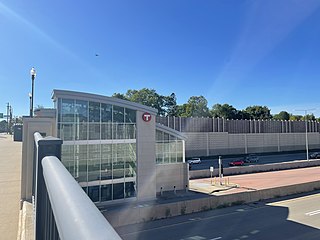
I-35W & 46th Street station is a Metro Orange Line bus rapid transit station located in Minneapolis, Minnesota. In addition to the BRT service, the station is also served by Metro route 578. The station was constructed as part of the I-35W/Minnesota State Highway 62 Crosstown Commons reconstruction project and opened in 2010. Consisting of two levels, one on East 46th Street, and the other in the median of Interstate 35W, the station was the first of its kind in Minnesota. The station allows for transit routes operating on I-35W to stop for riders without leaving the region's high occupancy toll lane system. The station was designed in anticipation of full bus rapid transit service along I-35W to downtown Minneapolis, a vision that was realized in 2021 with the opening of the Metro Orange Line. The station cost $4.5 million to build.

<span class="mw-page-title-main">Marq2 transit corridor</span> Public transit corridor through Minneapolis, Minnesota

The Marq2 transit corridor is a north–south thoroughfare in Minneapolis, Minnesota, United States. It consists of the parallel streets of Marquette and Second avenues in the downtown area. Each public streetway has two contraflow bus lanes with two lanes available for general-purpose traffic in the opposite direction. Vehicular transit flows south on Marquette Avenue and north on Second Avenue. The inner curb lane allows buses to stop for riders, while the second bus-only lane allows buses to pass each other along the corridor. Bus routes that operate on the corridor stop at every other block at an assigned gate with each route assigned a northbound and southbound gate. Gates are assigned letters A, B, C, or D on Marquette Avenue and E, F, G, and H on Second Avenue. Custom bus shelters are installed at each stop with heaters and real time transit information. The corridor primarily serves express buses operated by all five public transit agencies in the Twin Cities.

References

  1. 1 2 "Tags - E-ZPass".
  2. "How it works - E-ZPass".
  3. "News - MnPASS". Minnesota Department of Transportation. Retrieved November 10, 2018.
  4. Thiede, Dana (July 15, 2021). "MnPass express lane system to become E-ZPass". Minneapolis: KARE-TV. Retrieved July 16, 2021.
  5. "MnPASS: How It Works". Minnesota Department of Transportation. Retrieved April 7, 2018.
  6. "Managed Lanes". Freeway Management and Operations Handbook. Federal Highway Administration. 2011. Retrieved April 7, 2018.
  7. 1 2 3 4 5 "Express Lanes - E-ZPass".
  8. "Minnesota: Priced Dynamic Shoulder Lanes". Federal Highway Administration. Retrieved April 7, 2018.
  9. "MnPASS becomes E-ZPass Aug. 2; new Roseville-Blaine express lanes opening soon". Twin Cities. July 15, 2021. Retrieved November 8, 2023.
  10. "Orange Line FAQs". Metro Transit. Retrieved April 7, 2018.
  11. "MnPASS System Study - Phase 3". Metropolitan Council. Retrieved April 7, 2018.
  12. "Hwy 169 Mobility Study". Minnesota Department of Transportation. Archived from the original on April 8, 2018. Retrieved April 7, 2018.