Eagle Mountain, California

Last updated

Eagle Mountain
USA California location map.svg
Red pog.svg
Eagle Mountain
Location within the state of California
Coordinates: 33°51′27″N115°29′14″W / 33.85750°N 115.48722°W / 33.85750; -115.48722
CountryUnited States
State California
County Riverside
Elevation
[1]
1,365 ft (416 m)
Time zone UTC-8 (Pacific (PST))
  Summer (DST) UTC-7 (PDT)
GNIS feature ID1660573 [1]

Eagle Mountain is a ghost town in the California desert in Riverside County founded in 1948 by industrialist Henry J. Kaiser. The town is located at the entrance of the now-defunct Eagle Mountain iron mine, once owned by the Southern Pacific Railroad, then Kaiser Steel, and located on the southeastern corner of Joshua Tree National Park. The town's fully integrated medical care system, similar to other Kaiser operations in California, was the genesis of the modern-day Kaiser Permanente health maintenance organization. [2] Eagle Mountain is accessible by Kaiser Road (Riverside County Route R2) from California State Route 177, twelve miles (19 km) north of Desert Center, midway between Indio and the California/Arizona state line along Interstate 10.

Contents

History

Founded in 1948 by Kaiser Steel Corporation, Eagle Mountain is located at the entrance of the now-defunct Eagle Mountain iron mine. [3] [4] As the mine expanded, Eagle Mountain grew to a peak population of 4000. It had wide, landscaped streets lined with over four hundred homes, some with as many as four bedrooms. Two hundred trailer spaces and several boarding houses and dormitories provided living space for Kaiser's itinerant workforce. Other amenities included an auditorium, a park, a shopping center, a community swimming pool, lighted tennis courts, and a baseball diamond. Businesses included a bowling alley, two gas stations, eight churches, and three schools.

Kaiser Steel ruins in 2015 Eagle Mountain Kaiser Steel ruins.jpg
Kaiser Steel ruins in 2015

In the late 1930s, Kaiser built the West Coast's first fully integrated steel mill. In 1942, Kaiser built such a mill at Fontana, California, which is located 112 miles (180 km) west of the Eagle Mountain Mine. Today the Fontana mill site includes other successor mills and the Auto Club Speedway (formerly the California Speedway). Kaiser then purchased the idle mines from the Southern Pacific Railroad as a source of high-grade iron ore. This was a contingent strategy Kaiser used to utilize rail and raw materials for an industrial operation in a previously agricultural (pig farm) area.

Production at Fontana was initiated during WWII, increased iron shipments began in 1948, and a mining town was constructed below what was soon to become Southern California's largest iron mine. It connected to the Southern Pacific Railroad via a 51-mile-long (82 km) railroad branch known as the Eagle Mountain Railroad. It ran southwest from the mine to the northeast shore of the Salton Sea, just north of the Riverside–Imperial county line. Ore shipments to the Fontana steel plant began in October, with five to eight 100-car trains running weekly. The mine's 100 millionth ton of iron ore shipped was commemorated in a ceremony on August 17, 1977. [5]

Shutdown

Increased environmental concerns in the 1970s and stiff foreign competition led to a reduction in iron output and a drop in population to a low of 1980. In the summer of 1980, the mine shut down briefly, reopening on September 23. Only 750 workers were brought back to the town with an additional 150 (with uncertain employment futures) in Indio, some 60 miles (97 km) west.

On November 3, 1981, Kaiser Corporation announced the phasing out of half the Fontana works and the entire Eagle Mountain Mine operation over several years. The population dwindled as layoffs began. The grocery store closed in October 1982, and the post office, which had been active since 1951, closed in 1983. [3] In June of that year, the last official graduating class celebrated their commencement at Eagle Mountain High School, followed by the closing of both the mine and mill.

The ZIP code was 92241 until Eagle Mountain shut down; mail is now sent to the nearby Desert Center at 92239. The community is within area codes 442 and 760.

Resurgence

Eagle Mountain experienced a resurgence in 1986 when the California Department of Corrections proposed placing a unique privately operated prison for low-risk inmates in the town. The shopping center was converted in 1988 into the Eagle Mountain Community Correctional Facility, which operated until state budget problems and a fatal riot led to the closing of the prison in December 2003. Talks resumed in 2005 to reopen the prison facility.

1988 also saw a proposal to turn the gigantic 1.5-mile-long (2.4 km) by half-mile-wide (800 m) open-pit mine into a massive, high-tech sanitary landfill. The landfill, to be operated by a partnership of two privately operated trash collection firms and the successor to Kaiser Steel, Kaiser Ventures, [6] would ship trash by train from metropolitan Los Angeles area via the Eagle Mountain Railroad. A company subsidiary, Mine Reclamation Corp. of Palm Desert, is the landfill developer. [7] Due to numerous lawsuits regarding the environmental effects of the landfill, the project was repeatedly delayed. The private partnership decided in late 1999 to terminate the project. Their share of the project was bought by Kaiser Ventures, making it the controlling owner of the project. [8]

The Riverside County Board of Supervisors approved the project in October 1992 after EPA approval of the project. In August 2000, Kaiser Ventures reached an agreement with the Los Angeles Sanitation District (LASD – a public entity comprising several public waste collection agencies), to purchase the landfill project as a replacement for the Puente Hills Landfill, which would be nearing the end of its useful life. Trash was to be shipped by rail from the Los Angeles area via the abandoned Eagle Mountain Railroad line. The sale agreement states that all lawsuits and claims regarding the project were to be resolved. As of 2008, there was one lawsuit pending. Much has changed in the waste business since 2000. A reduction in waste generated because of recycling has reduced the urgency for the new landfill. In addition, the Los Angeles Sanitation District purchased another landfill site in Imperial County. In May 2013, the LASD discontinued plans to convert the Eagle Mountain mine into a landfill. [9]

A 1300 MW pumped-storage hydroelectricity plant was proposed by Eagle Crest Energy. [10] The company agreed to buy the land from CIL&D (the new name of Kaiser Ventures) in July 2015. The Eagle Mountain Pumped Storage Project would pump groundwater from the Chuckwalla Valley aquifer into two reservoirs comprising former mining pits, where water would be pumped from the lower reservoir to the upper reservoir during low electricity demand and pumped back down through turbines during high electricity demand. In November 2016, NextEra Energy announced their partnership with Eagle Crest in the project. The project is praised by supporters for the purpose of bringing more renewable energy in California, while also being criticized by environmentalists for potential damages to plant and animal life in and around Joshua Tree National Park. [11] [12] [13]

On April 17th, 2023, the land and mining site were purchased for $22.5 million by California-based Ecology Mountain Holdings. It was previously owned by Eagle Mountain Acquisitions, one of the few mining subsidiaries that owned the land within the last 40 years. It is currently unknown what the company intends on doing with the area. [14] [15]

Climate

According to the Köppen Climate Classification system, Eagle Mountain has a hot desert climate, abbreviated "BWh" on climate maps. The hottest temperature recorded in Eagle Mountain was 120 °F (48.9 °C) on June 26, 1970, while the coldest temperature recorded was 20 °F (−6.7 °C) on January 22, 1937. [16]

Climate data for Eagle Mountain, California, 1991–2020 normals, extremes 1933–present
MonthJanFebMarAprMayJunJulAugSepOctNovDecYear
Record high °F (°C)85
(29)
91
(33)
102
(39)
105
(41)
111
(44)
120
(49)
119
(48)
118
(48)
117
(47)
109
(43)
95
(35)
85
(29)
120
(49)
Mean maximum °F (°C)74.7
(23.7)
78.3
(25.7)
87.5
(30.8)
95.6
(35.3)
102.2
(39.0)
109.6
(43.1)
112.8
(44.9)
110.5
(43.6)
105.5
(40.8)
97.4
(36.3)
84.9
(29.4)
73.8
(23.2)
113.7
(45.4)
Mean daily maximum °F (°C)64.3
(17.9)
68.0
(20.0)
74.6
(23.7)
81.5
(27.5)
90.0
(32.2)
99.4
(37.4)
103.9
(39.9)
102.8
(39.3)
97.3
(36.3)
85.5
(29.7)
72.9
(22.7)
63.2
(17.3)
83.6
(28.7)
Daily mean °F (°C)55.2
(12.9)
58.4
(14.7)
64.5
(18.1)
70.9
(21.6)
79.5
(26.4)
88.6
(31.4)
93.6
(34.2)
92.6
(33.7)
86.7
(30.4)
75.3
(24.1)
63.3
(17.4)
54.3
(12.4)
73.6
(23.1)
Mean daily minimum °F (°C)46.1
(7.8)
48.8
(9.3)
54.5
(12.5)
60.2
(15.7)
68.9
(20.5)
77.8
(25.4)
83.4
(28.6)
82.5
(28.1)
76.2
(24.6)
65.1
(18.4)
53.8
(12.1)
45.5
(7.5)
63.6
(17.5)
Mean minimum °F (°C)37.8
(3.2)
40.0
(4.4)
44.4
(6.9)
49.9
(9.9)
56.5
(13.6)
67.4
(19.7)
74.8
(23.8)
73.1
(22.8)
66.5
(19.2)
54.6
(12.6)
43.7
(6.5)
37.1
(2.8)
35.2
(1.8)
Record low °F (°C)20
(−7)
29
(−2)
31
(−1)
40
(4)
45
(7)
47
(8)
64
(18)
63
(17)
51
(11)
37
(3)
35
(2)
25
(−4)
20
(−7)
Average precipitation inches (mm)0.59
(15)
0.60
(15)
0.40
(10)
0.07
(1.8)
0.07
(1.8)
0.01
(0.25)
0.28
(7.1)
0.41
(10)
0.36
(9.1)
0.13
(3.3)
0.11
(2.8)
0.62
(16)
3.65
(92.15)
Average precipitation days (≥ 0.01 in)2.72.82.00.90.30.11.21.81.51.10.91.817.1
Source 1: NOAA [17]
Source 2: National Weather Service [16]

Schools

The Desert Center Unified School District at one time operated four schools in the Eagle Mountain and Desert Center areas. Eagle Mountain Elementary School was located in the center of the town, Henry J. Kaiser Junior High School and Eagle Mountain High School were located on the east, and Desert Center Elementary School was located in Desert Center, 11 miles away. The class of 1987 was the last to graduate from Eagle Mountain High School. In 1987, the school district converted the high school into the Eagle Mountain Elementary School, [18] in operation since 1983, educating students in the grades kindergarten through 8th grade. [14]

The remaining three school sites were closed and boarded up. Local high school students are bused to Palo Verde High School in Blythe, California, making the 120-mile round trip every day. The remaining students in the school district are children of the few full-time residents of Desert Center and children of the employees of the two nearby Metropolitan Water District pumping plants.

Film

A portion of the Eagle Mountain Railroad was used in the filming of the 1986 movie Tough Guys in a scene wherein a train is hijacked - pulled by a locomotive Southern Pacific 4449 - and run full throttle to the Mexican border. During the filming of the exterior shots of Southern Pacific 4449, the train was stored nightly at the Eagle Mountain rail yards. The local school children from Eagle Mountain School took a field trip in early 1986 to visit the train on the location of the shoot along the Eagle Mountain Railroad south of Interstate 10. [19]

Other films using Eagle Mountain locations include [20]

Characteristic concrete arches as seen in Tenet Eagle Mountain Kaiser Steel arches.jpg
Characteristic concrete arches as seen in Tenet

Television

Top Gear USA has used Eagle Mountain at least 3 times. In season 2's third episode, "America's Strongest Pickup," Eagle Mountain was used for the final challenge including pulling down a house. And episode 8 "Hollywood Cars" racing a Subaru WRX against a motorcycle. The final challenge in the 13th episode of Top Gear USA's third season was staged at Eagle Mountain. Entitled 'Doomsday Drive,' Eagle Mountain served as a stand-in for a post-apocalyptic setting. [23]

See also

Related Research Articles

<span class="mw-page-title-main">Calico, California</span> Place in California, United States

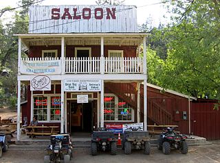
Calico is a ghost town and former mining town in San Bernardino County, California, United States. Located in the Calico Mountains of the Mojave Desert region of Southern California, it was founded in 1881 as a silver mining town, and was later converted into a county park named Calico Ghost Town. Located off Interstate 15, it lies 3 miles (4.8 km) from Barstow and 3 miles from Yermo. Giant letters spelling CALICO are visible, from the highway, on the Calico Peaks behind it. Walter Knott purchased Calico in the 1950s, and rebuilt all but the five remaining original buildings to look as they did in the 1880s. Calico received California Historical Landmark #782, and in 2005 was proclaimed by then-Governor Arnold Schwarzenegger to be California's Silver Rush Ghost Town.

<span class="mw-page-title-main">Rhyolite, Nevada</span> Ghost town in Nevada, United States

Rhyolite is a ghost town in Nye County, in the U.S. state of Nevada. It is in the Bullfrog Hills, about 120 miles (190 km) northwest of Las Vegas, near the eastern boundary of Death Valley National Park.

<span class="mw-page-title-main">Daggett, California</span> Unincorporated community in California, United States

Daggett is an unincorporated community located in San Bernardino County, California in the United States. The town is located on Interstate 40 ten miles (16 km) east of Barstow. The town has a population of about 200. The ZIP code is 92327 and the community is inside area code 760.

<span class="mw-page-title-main">Gilman, Colorado</span> Town in Colorado, United States

Gilman is an abandoned mining town in southeastern Eagle County, Colorado, United States. The Gilman post office operated from November 3, 1886, until April 22, 1986. The U.S. Post Office at Minturn now serves Gilman postal addresses.

<span class="mw-page-title-main">Desert Center, California</span> Census-designated place in California, United States

Desert Center is a census designated place in the Colorado Desert in Riverside County, California. It is in southern California, between the cities of Indio and Blythe at the junction of Interstate 10 and State Route 177, about halfway between Phoenix and Los Angeles. The ZIP Code is 92239, and the community is in telephone area codes 442 and 760. The elevation is 656 feet (200 m). The population was 204 at the 2010 census.

The Eagle Mountains are located in northeastern Riverside County, California, U.S.

<span class="mw-page-title-main">Dawson, New Mexico</span> Ghost town in New Mexico, United States

Dawson is a ghost town in Colfax County, New Mexico, United States. Dawson was the site of two separate coal mining disasters in 1913 and 1923. Dawson is located approximately 17 miles northeast of Cimarron.

The Eagle Mountain Railroad (EMRR) was a private railroad in California, owned by the Kaiser Steel Corporation, and is owned today by Kaiser Steel's successor, Kaiser Ventures, Inc. of Ontario, California.

Ludlow is an unincorporated community in the Mojave Desert on Interstate 40, located in San Bernardino County, California, United States. The older remains of the ghost town are along historic Route 66.

<span class="mw-page-title-main">Kaiser Steel</span> Defunct American steel manufacturer

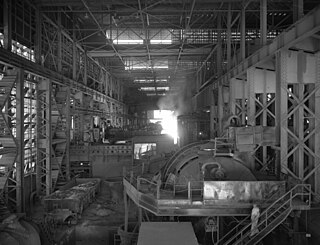
Kaiser Steel was an integrated steel mill near Fontana, California, founded by Henry J. Kaiser on December 1, 1941. The plant's first blast furnace, "Bess No. 1" was fired up on December 30, 1942, and the first steel plate was produced in August 1943 for the Pacific Coast shipbuilding industry amid World War II. The Fontana facility produced about 75 million tons of steel over its history.

<span class="mw-page-title-main">Crown King, Arizona</span> Unincorporated community in Yavaipai County

Crown King is an unincorporated community in Yavapai County, Arizona, United States, located at an elevation of 5,771 feet (1,759 m). Crown King has a ZIP Code of 86343; in 2000, the population of the 86343 ZCTA was 133. The site of a former gold mining town, Crown King is 28 miles west of Interstate 17 on Senator Highway, high in the Bradshaw Mountains. The community is named after the Crowned King mine, but the name was shortened to Crown King in 1888. Horsethief Basin Lake resides 6.5 miles southeast of Crown King on Crown King Rd/Forest 259 Rd.

<span class="mw-page-title-main">Hart, California</span> Ghost town in California, United States

Hart was a short-lived gold mining town located in the Mojave desert, in San Bernardino County, California. It existed between 1908 and 1915, and was located on the northeastern edge of Lanfair Valley near the New York Mountains. The area is now in the Castle Mountains National Monument, administered by the National Park Service.

<span class="mw-page-title-main">Cerro Gordo Mines</span> Abandoned mines in the Inyo Mountains, California

The Cerro Gordo Mines are a collection of abandoned mines located in Cerro Gordo in the Inyo Mountains, Inyo County, near Lone Pine, California. Mining operations spanned 1866 to 1957, producing high grade silver, lead, zinc ore, and more rarely gold ore and copper ore. Some ore was smelted on site, but larger capacity smelters were eventually constructed along the shore of nearby Owens Lake.

<span class="mw-page-title-main">Leadville mining district</span> Mining district

The Leadville mining district, located in the Colorado Mineral Belt, was the most productive silver-mining district in the state of Colorado and hosts one of the largest lead-zinc-silver deposits in the world. Oro City, an early Colorado gold placer mining town located about a mile east of Leadville in California Gulch, was the location to one of the richest placer gold strikes in Colorado, with estimated gold production of 120,000–150,000 ozt, worth $2.5 to $3 million at the then-price of $20.67 per troy ounce.

Desert Center Unified School District is located in the eastern part of Riverside County in California. The district services the unincorporated areas of Eagle Mountain, Desert Center, Lake Tamarisk and Chiriaco Summit.

<span class="mw-page-title-main">Joshua Tree National Park</span> National park in California, United States

Joshua Tree National Park is an American national park in southeastern California, east of San Bernardino and Los Angeles and north of Palm Springs. It is named after the Joshua trees native to the Mojave Desert. Originally declared a national monument in 1936, Joshua Tree was redesignated as a national park in 1994 when the U.S. Congress passed the California Desert Protection Act. Encompassing a total of 795,156 acres – slightly larger than the state of Rhode Island – the park includes 429,690 acres of designated wilderness. Straddling San Bernardino and Riverside Counties, the park includes parts of two deserts, each an ecosystem whose characteristics are determined primarily by elevation: the higher Mojave Desert and the lower Colorado Desert. The Little San Bernardino Mountains traverse the southwest edge of the park.

<span class="mw-page-title-main">Elcor, Minnesota</span> Ghost town in Minnesota, United States

Elcor is a ghost town, or more properly, an extinct town, in the U.S. state of Minnesota that was inhabited between 1897 and 1956. It was built on the Mesabi Iron Range near the city of Gilbert in St. Louis County. Elcor was its own unincorporated community before it was abandoned and was never a neighborhood proper of the city of Gilbert. Not rating a figure in the national census, the people of Elcor were only generally considered to be citizens of Gilbert. The area where Elcor was located was annexed by Gilbert when its existing city boundaries were expanded after 1969.

<span class="mw-page-title-main">Waterloo Mining Railroad</span>

The Waterloo Mining Railroad, also known as the Calico Railroad or Daggett-Calico Railroad, was a 3 ft narrow gauge railroad built to carry silver ore from the mines in the Calico Mountains north of Calico to the mills located at Elephant Mountain near Daggett, California, from 1888 to 1903.

Barnwell, originally a rail camp named Summit, then Manvel, was a former railhead serving local mining camps, now a ghost town, in San Bernardino County, California. It lies at an elevation 4806 feet in the New York Mountains.

Hedges, later renamed Tumco, is a locale, a ghost town, site of a former mining town, in Imperial County, California. It lies at an elevation of 617 feet / 188 meters along the Tumco Wash in the Cargo Muchacho Mountains. Nearby is the Hedges Cemetery at an elevation of 643 feet, at 32°53′04″N114°49′52″W.

References

  1. 1 2 U.S. Geological Survey Geographic Names Information System: Eagle Mountain, California
  2. Rickey Hendricks, A Model for National Health Care: The History of Kaiser Permanente (New Brunswick, NJ: Rutgers University Press, 1993), ISBN   0-8135-1929-2, 13-26
  3. 1 2 Durham, David L. (2001). Place-Names of California's Desert Counties. Clovis, CA: World Dancer Press. p. 56. ISBN   1-884995-31-4.
  4. Dubois, Robert; Brummett, Richard (1968). Ridge, John (ed.). Geology of the Eagle Mountain Mine Area, in Ore deposits of the United States, 1933-1967. New York: The American Institute of Mining, Metallurgical, and Petroleum Engineers, Inc. pp. 1592–1606.
  5. "Eagle Mountain ships 100-millionth ton of ore". Palo Verde Valley Times. September 1, 1977.
  6. "Eagle Mountain". Archived from the original on May 14, 2008.
  7. "Inland News | PE.com | Southern California News | News for Inland Southern California".
  8. Castleman, Terry (May 24, 2023). "A California ghost town sells for $22.6 million to mysterious company". Los Angeles Times. Retrieved May 30, 2023.
  9. Clarke, Chris (May 24, 2013). "Proposed Trash Dump Next to Joshua Tree National Park Canceled". KCET.org. Retrieved December 5, 2014.
  10. "In shadow of Joshua Tree, debating an old mine's future". Desert Sun.
  11. Zimmerman, Janet (July 8, 2015). "JOSHUA TREE: Plan aims to turn desert water to electricity". The Press Enterprise . Retrieved February 28, 2017.
  12. Roth, Sammy (November 25, 2016). "Eagle Mountain hydropower gets boost from NextEra". The Desert Sun . Retrieved February 28, 2017.
  13. "Opinion: Time for California to "follow the science" on pumped hydro energy storage". Hydro Review. June 25, 2021.
  14. 1 2 Valintino, Silas (May 21, 2023). "A mystery buyer just purchased entire California ghost town Eagle Mountain for $22.5M". SFGate . Retrieved May 23, 2023.
  15. Napolitano, Elizabeth (May 22, 2023). "Mystery buyer purchases California ghost town for $22.5 million". CBS News . Retrieved May 23, 2023.
  16. 1 2 "NOAA Online Weather Data – NWS Phoenix". National Weather Service. Retrieved January 7, 2023.
  17. "U.S. Climate Normals Quick Access – Station: Eagle MTN, CA". National Oceanic and Atmospheric Administration. Retrieved January 7, 2023.
  18. "Eagle Mountain Elementary School". GreatSchools.org.
  19. "Tough Guys" via www.imdb.com.
  20. "Titles with locations including Eagle Mountain, California, USA". IMDb .
  21. "Live from Baghdad". Archived from the original on October 13, 2008.
  22. "Constanstine". Archived from the original on October 13, 2008.
  23. "Eagle Mountain Video - Top Gear - HISTORY.com". Archived from the original on June 19, 2015. Retrieved June 18, 2015.