Eagle River, Michigan

Last updated

Eagle River, Michigan
Keweenaw County Courthouse Eagle River Michigan 2021-4252.jpg
Keweenaw County Courthouse in Eagle River
Eagle River, MI location.png
Location within Keweenaw County
USA Michigan location map.svg
Red pog.svg
Eagle River
Location within the state of Michigan
Coordinates: 47°24′50″N88°17′44″W / 47.41389°N 88.29556°W / 47.41389; -88.29556
Country United States
State Michigan
County Keweenaw
Townships Allouez and Houghton
Area
[1]
  Total6.22 sq mi (16.12 km2)
  Land6.20 sq mi (16.07 km2)
  Water0.02 sq mi (0.05 km2)
Elevation
[2]
650 ft (200 m)
Population
 (2020)
  Total65
  Density10.48/sq mi (4.05/km2)
Time zone UTC-5 (Eastern (EST))
  Summer (DST) UTC-4 (EDT)
ZIP code(s)
49950 (Mohawk)
Area code 906
GNIS feature ID625096 [2]

Eagle River is an unincorporated community and census-designated place (CDP) in the U.S. state of Michigan. It is the county seat of Keweenaw County. [3] Its population was 65 at the 2020 census, [4] which makes it by far the least-populated county seat in the state of Michigan. [5] As an unincorporated community, Eagle River has no legal autonomy and is part of Allouez Township and Houghton Township.

Contents

History

The Houghton Township Community Center in Eagle River Eagle River Museum--Houghton Township Community Center Michigan 2021-4264.jpg
The Houghton Township Community Center in Eagle River

Eagle River was a boom town of the copper mining era in the Keweenaw. Copper was discovered in 1845 at the Cliff Range nearby, the so-called "Cliff Lode". The land of the Eagle River community had been leased by the Keweenaw Copper Company in 1843. It was later platted by the Phoenix Company and sold as individual lots. The first postmaster was named on October 24, 1845. It was part of Houghton County until Keweenaw County was organized in 1861. The profitability of the area's copper mines had begun to decline sharply by around 1870.

The Eagle River Timber Bridge is a wooden arch bridge that carries highway M-26 over the Eagle River. It opened in 1990 as a replacement for the historic Lake Shore Drive Bridge that runs parallel to it.

Eagle River is home to the Holy Transfiguration Skete, a Byzantine Catholic monastery and community, which is known for producing jams and other foodstuffs from berries collected in the nearby forests. Holy Transfiguration is one of only a few Byzantine Catholic monasteries in the United States.

The community of Eagle River was listed as a newly-organized census-designated place for the 2010 census, meaning it now has officially defined boundaries and population statistics for the first time. [6]

Geography

According to the United States Census Bureau, Eagle River has a total area of 5.96 square miles (15.44 km2), of which 5.94 square miles (15.38 km2) is land and 0.02 square miles (0.05 km2) (0.34%) is water.

Eagle River is listed as being part of both Allouez Township and Houghton Township. Only a very small portion of 0.01 square miles (0.03 km2) and no residents are within the Allouez Township portion of the community, while the majority of land and all residents are within Houghton Township. [7]

The community is on M-26 on the north side of the Keweenaw Peninsula on the shores of Lake Superior. It is about 27 miles (43 km) northeast of Houghton and is situated on the mouth of the Eagle River. The Mohawk 49950 ZIP Code serves the community.

The decommissioned Eagle River Light is on the west bank of the river on a sand bluff overlooking Lake Superior, although the view is partially obscured by condominiums.

Demographics

As of 2020, its population was 65. Its median household income was $57,500. [4]

Historical population
CensusPop.Note
2020 65
U.S. Decennial Census [8]

Transportation

Related Research Articles

<span class="mw-page-title-main">Houghton, Michigan</span> City in Michigan, United States

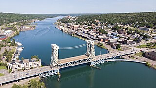
Houghton is the largest city and county seat of Houghton County in the U.S. state of Michigan. Located on the Keweenaw Peninsula, Houghton is the largest city in the Copper Country region. It is the fifth-largest city in the Upper Peninsula, with a population of 8,386 at the 2020 census. Houghton is the principal city of the Houghton micropolitan area, which includes all of Houghton and Keweenaw counties. Houghton lies upon the Keweenaw Waterway, a partly natural, partly artificial waterway connecting at both ends to Lake Superior. Across the waterway from Houghton lies the city of Hancock.

<span class="mw-page-title-main">Hancock, Michigan</span> City in Michigan, United States

Hancock is a city in the Upper Peninsula of the U.S. state of Michigan. The population of Hancock was 4,501 at the 2020 census. The city is located within Houghton County, and is situated upon the Keweenaw Waterway, a channel of Lake Superior that cuts across the Keweenaw Peninsula. Hancock is located across the Keweenaw Waterway from the city of Houghton, and is connected to that city by the Portage Lake Lift Bridge. The city is located within Michigan's Copper Country region.

<span class="mw-page-title-main">Ontonagon County, Michigan</span> County in Michigan, United States

Ontonagon County is a county in the Upper Peninsula of the U.S. state of Michigan. As of the 2020 census, the population was 5,816, making it Michigan's third-least populous county. The county seat is Ontonagon. The county was set off in 1843, and organized in 1848. Its territory had been organized as part of Chippewa and Mackinac counties. With increasing population in the area, more counties were organized. After Ontonagon was organized, it was split to create Gogebic County. It is also the westernmost county in United States that lies within the Eastern Time Zone.

<span class="mw-page-title-main">Keweenaw County, Michigan</span> County in Michigan, United States

Keweenaw County is a county in the western Upper Peninsula of the U.S. state of Michigan. As of the 2020 census, the county's population was 2,046, making it Michigan's least populous county. It is also the state's largest county by total area, including the waters of Lake Superior, as well as the state's northernmost county. The county seat is Eagle River.

<span class="mw-page-title-main">Houghton County, Michigan</span> County in Michigan, United States

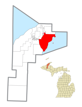
Houghton County is a county in the Upper Peninsula in the U.S. state of Michigan. As of the 2020 Census, the population was 37,361. The county seat and largest city is Houghton. Both the county and the city were named for Michigan State geologist and Detroit Mayor Douglass Houghton.

<span class="mw-page-title-main">L'Anse Township, Michigan</span> Civil township in Michigan, United States

L'Anse Township is a civil township of Baraga County in the U.S. state of Michigan. As of the 2020 census, the township population was 3,551. The township contains Mount Arvon and Mount Curwood, Michigans highest and second-highest points, as well as the village of L'Anse.

<span class="mw-page-title-main">Adams Township, Houghton County, Michigan</span> Civil township in Michigan, United States

Adams Township is a civil township of Houghton County in the U.S. state of Michigan. As of the 2020 census, the township population was 2,540.

<span class="mw-page-title-main">Calumet Charter Township, Michigan</span> Charter township in Michigan, United States

Calumet Township, officially the Charter Township of Calumet, is a charter township of Houghton County in the Upper Peninsula of the U.S. state of Michigan. The population was 6,263 at the 2020 census. Even with a decreasing population, the township remains the largest township by population in Houghton County.

<span class="mw-page-title-main">Copper City, Michigan</span> Village in Michigan, United States

Copper City is a village in Houghton County of the U.S. state of Michigan. The population was 187 at the 2020 census. The village is within Calumet Township. With an area of 0.08 square miles (0.21 km2), it is the second-smallest incorporated municipality by area in the state of Michigan after the nearby village of Ahmeek.

<span class="mw-page-title-main">Laurium, Michigan</span> Village in Michigan, United States

Laurium is a village in Calumet Township, Houghton County in the U.S. state of Michigan, in the center of the Keweenaw Peninsula. The population was 1,977 at the 2010 census.

<span class="mw-page-title-main">Torch Lake Township, Houghton County, Michigan</span> Civil township in Michigan, United States

Torch Lake Township is a civil township of Houghton County in the U.S. state of Michigan. As of the 2010 census, the population of the township was 1,880. The township was established in 1886 and is one of the largest townships in Houghton County by area. It is surrounded by the Torch Lake, the Portage Lake, and Lake Superior. As well as a large number of unincorporated communities, the township also includes a portion of the Baraga State Forest which lies along the shores of Keweenaw Bay. The township borders Schoolcraft Township to the north, Osceola Township to the northwest, and Chassell Township to the southwest. The community of Hubbell serves as the major population center of the township, as well as hosting the Township Hall itself. The mostly uninhabited 91-acre Rabbit Island, located offshore in Lake Superior, is a part of the township.

<span class="mw-page-title-main">Ahmeek, Michigan</span> Village in Michigan, United States

Ahmeek is a village in Keweenaw County in the U.S. state of Michigan. The village is located within Allouez Township. The population was 127 at the 2020 census.

<span class="mw-page-title-main">Allouez Township, Michigan</span> Civil township in Michigan, United States

Allouez Township is a civil township of Keweenaw County in the U.S. state of Michigan. The population was 1,428 at the 2020 census.

<span class="mw-page-title-main">Eagle Harbor Township, Michigan</span> Civil township in Michigan, United States

Eagle Harbor Township is a civil township of Keweenaw County in the U.S. state of Michigan. The population was 217 at the 2020 census. The township is located on the Keweenaw Peninsula and also includes the southwestern portion of Isle Royale National Park.

<span class="mw-page-title-main">Grant Township, Keweenaw County, Michigan</span> Civil township in Michigan, United States

Grant Township is a civil township of Keweenaw County in the U.S. state of Michigan. The population was 275 at the 2020 census. Grant Township is one of the most isolated municipalities in Michigan, as it forms the tip of the Keweenaw Peninsula, which projects into Lake Superior.

<span class="mw-page-title-main">Houghton Township, Michigan</span> Civil township in Michigan, United States

Houghton Township is a civil township of Keweenaw County in the U.S. state of Michigan. The population was 72 at the 2020 census.

<span class="mw-page-title-main">Copper Harbor, Michigan</span> Census-designated place & unincorporated community in Michigan, United States

Copper Harbor is an unincorporated community and census-designated place (CDP) located in Keweenaw County in the U.S. state of Michigan. It is located within Grant Township. The population of the CDP was 136 as of the 2020 census.

<span class="mw-page-title-main">Eagle Harbor, Michigan</span> Census-designated place & unincorporated community in Michigan, United States

Eagle Harbor is an unincorporated community and census-designated place located on the north side of the Keweenaw Peninsula within Eagle Harbor Township, Keweenaw County in the U.S. State of Michigan. Its population was 69 as of the 2020 census. M-26 passes through this community. This hamlet was especially popular with the sailors in days past, as it had a good steamboat landing and is about equally distant from Sault Sainte Marie, Michigan, and Duluth, Minnesota. It was the first stop for supplies for the many boats on Lake Superior.

<span class="mw-page-title-main">Dollar Bay, Michigan</span> Census-designated place & unincorporated community in Michigan, United States

Dollar Bay is a census-designated place (CDP) in Houghton County, Michigan, United States. The population was 1,082 at the 2010 census.

Mohawk is an unincorporated community and census-designated place (CDP) in the U.S. state of Michigan. Located in Keweenaw County, it is within Allouez Township. As an unincorporated community, Mohawk has no legally defined boundaries or population statistics of its own but does have its own post office with the 49950 ZIP Code. The ZIP includes most of mainland Keweenaw County and also uses the Eagle Harbor and Eagle River designations.

References

  1. "2020 U.S. Gazetteer Files". United States Census Bureau. Retrieved May 21, 2022.
  2. 1 2 "Eagle River". Geographic Names Information System . United States Geological Survey, United States Department of the Interior.
  3. "Find a County". National Association of Counties. Archived from the original on July 12, 2012. Retrieved June 7, 2011.
  4. 1 2 "Explore Census Data". data.census.gov. Retrieved August 3, 2023.
  5. "2010 Census Gazetteer Files - Places: Michigan". U.S. Census Bureau . Retrieved August 1, 2017.
  6. "Michigan: 2010 Population and Housing Unit Counts 2010 Census of Population and Housing" (PDF). 2010 United States Census . United States Census Bureau. September 2012. p. III-6. Retrieved August 8, 2016.
  7. "Michigan: 2010 Population and Housing Unit Counts 2010 Census of Population and Housing" (PDF). 2010 United States Census . United States Census Bureau. September 2012. p. 28 Michigan. Retrieved April 3, 2020.
  8. "Census of Population and Housing". Census.gov. Retrieved June 4, 2016.