
Suffolk is a ceremonial county of England in East Anglia. It borders Norfolk to the north, Cambridgeshire to the west and Essex to the south; the North Sea lies to the east. The county town is Ipswich; other important towns include Lowestoft, Bury St Edmunds, Newmarket, and Felixstowe which has one of the largest container ports in Europe.
Ipswich is a town and borough in Suffolk, England, of which it is the county town. The town is located in East Anglia about 9.9 mi (16 km) away from the mouth of the River Orwell and the North Sea.

Mid Suffolk is a local government district in Suffolk, England. Its council was based in Needham Market until late 2017, and is currently sharing offices with the Suffolk County Council in Ipswich. The largest town of Mid Suffolk is Stowmarket. The population of the district taken at the 2011 Census was 96,731.

East Suffolk, along with West Suffolk, was created in 1888 as an administrative county of England. The administrative county was based on the eastern quarter sessions division of Suffolk. East Suffolk County Council's headquarters were at East Suffolk County Hall in Ipswich.

Rushmere St Andrew is a village, civil parish and electoral ward adjacent to part of the eastern edge of the borough of Ipswich in the East Suffolk district of Suffolk, England. The parish includes most of Rushmere Heath and parts of the Ipswich suburb of Broke Hall as well as the village of Rushmere St. Andrew, from which it draws its name. The parish was formed in 1894 from the rural part of the parish of Rushmere.

Suffolk County Council is the administrative authority for the county of Suffolk, England. It is run by 75 elected county councillors representing 63 divisions. It is a member of the East of England Local Government Association.

Wissett is a village and civil parish in the English county of Suffolk. It is 2 miles (3.2 km) north-east of the market town of Halesworth in the East Suffolk district. Historically, it was in the Blything Hundred.
The University of Suffolk is a public university situated in Suffolk and Norfolk, England. The modern university was established in 2007 as University Campus Suffolk (UCS), and the institution was founded as a unique collaboration between the University of East Anglia and the University of Essex. The university's current name was adopted after it was granted independence in 2016 by the Privy Council and was awarded university status.
Otley is a village and civil parish in the English county of Suffolk. It is around 7 miles (11 km) north-east of Ipswich in the East Suffolk district. The parish, which covers an area of about 9 square kilometres (3.5 sq mi), had a population of 676 at the 2011 United Kingdom census. The B1079 road runs through the village, meeting the B1078 to the south of the parish at Otley Green.

Shadingfield is a village and civil parish in the East Suffolk district of the English county of Suffolk. It is located around 4 miles (6.4 km) south of Beccles in the north of the county.

Ipswich Borough Council, founded in 1974 after the abolition of the County Borough of Ipswich, governs the non-metropolitan district of Ipswich in Suffolk. It is the second tier of a two-tier system, fulfilling functions such as refuse collection, housing and planning, with Suffolk County Council providing county council services such as transport, education and social services.

Willingham St Mary, also known simply as Willingham, is a village and civil parish in the English county of Suffolk located about 3.5 miles (6 km) south of Beccles in the East Suffolk district. At the 2011 United Kingdom census it had a population of 152.

Weston is a village and civil parish in the English county of Suffolk. It is around 2 miles (3 km) south of Beccles in the East Suffolk district. The parish lies either side of the A145 road and is crossed by the Ipswich to Lowestoft railway line. Neighbouring parishes include Ellough, Ringsfield, Willingham St Mary and Shadingfield. The village is largely dispersed with a population of around 230.

Ringsfield is a village and civil parish in the English county of Suffolk. It is 2 miles (3.2 km) south-west of Beccles in the East Suffolk district.

The Municipal Borough of Ipswich was created in 1835 by the Municipal Corporations Act 1835. It was the form of local government for the ancient borough of Ipswich until the Local Government Act 1888 replaced it with the County Borough of Ipswich in 1889. Both originated from the ancient borough of Ipswich. The local authority was Ipswich Corporation. Following the passage of the Reform Act 1832, the government set up a Royal Commission in July 1833 to investigate how local councils worked. In 1974 it was replaced by the non-metropolitan district of Ipswich and Ipswich Borough Council became the local authority, with county council duties fulfilled by Suffolk County Council.

West Suffolk County Council was the county council of the non-metropolitan county of West Suffolk in east England. It came into its powers on 1 April 1889 and acted as the governing authority for the county until it was amalgamated with East Suffolk County Council to form Suffolk County Council in 1974. The county council was based at the Shire Hall Complex in Bury St Edmunds.
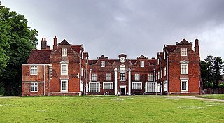
East Suffolk County Hall is a historic building located in St Helen's Street in Ipswich. The building, which was the headquarters of East Suffolk County Council until 1974 and then of Suffolk County Council until 2004, is a Grade II listed building.

St Margaret South Elmham is a village and civil parish in the north of the English county of Suffolk. It is 4 miles (6.4 km) south-west of the market town of Bungay in the East Suffolk district. It is one of the parishes surrounding Bungay which are known as The Saints.

Endeavour House is a municipal building in Russell Road in Ipswich, Suffolk, England. It is the meeting place and offices of Suffolk County Council. The Babergh District Council and Mid Suffolk District Council also use the building for their offices and meeting place.

East Suffolk is a local government district in Suffolk, England, which was established on 1 April 2019, following the merger of the existing Suffolk Coastal and Waveney districts. At the 2011 census, the two districts had a combined population of 239,552.

