East Troy, Wisconsin

Last updated

East Troy, Wisconsin
Walworth County Wisconsin Incorporated and Unincorporated areas East Troy Highlighted.svg
Location of East Troy in Walworth County, Wisconsin.
Coordinates: 42°48′N88°24′W / 42.800°N 88.400°W / 42.800; -88.400
Country Flag of the United States.svg  United States
State Flag of Wisconsin.svg  Wisconsin
County Walworth
Area
[1]
  Total4.57 sq mi (11.83 km2)
  Land4.53 sq mi (11.72 km2)
  Water0.04 sq mi (0.11 km2)
Elevation
[2]
833 ft (254 m)
Population
 (2020) [3]
  Total5,673
  Density952.94/sq mi (367.93/km2)
Time zone UTC-6 (Central (CST))
  Summer (DST) UTC-5 (CDT)
ZIP Code
53120
Area code 262
FIPS code 55-22125 [4]
GNIS feature ID1564382 [2]
Website easttroywi.gov

East Troy is a Village in Walworth County, Wisconsin, United States. The population was 5,673 at the 2020 census. The Village is located southwest of the Town of East Troy. A small portion extends into the adjacent Town of Troy. As of 2020, the Village of East Troy has become a rapid growing community in housing and businesses.

Contents

Geography

East Troy is located at 42°48′N88°24′W / 42.800°N 88.400°W / 42.800; -88.400 (42.7868, -88.4036). [5]

According to the United States Census Bureau, the village has a total area of 4.51 square miles (11.68 km2), of which, 4.47 square miles (11.58 km2) of it is land and 0.04 square miles (0.10 km2) is water. [6]

Demographics

Historical population
CensusPop.Note
1880 368
1890 46325.8%
1910 673
1920 77314.9%
1930 8003.5%
1940 92515.6%
1950 1,05213.7%
1960 1,45538.3%
1970 1,71117.6%
1980 2,38539.4%
1990 2,66411.7%
2000 3,56433.8%
2010 4,28120.1%
2020 5,67332.5%
U.S. Decennial Census [7]

2010 census

As of the census [3] of 2010, there were 4,281 people, 1,737 households, and 1,125 families living in the village. The population density was 957.7 inhabitants per square mile (369.8/km2). There were 1,866 housing units at an average density of 417.4 per square mile (161.2/km2). The racial makeup of the village was 95.9% White, 0.4% African American, 0.5% Native American, 0.6% Asian, 0.1% Pacific Islander, 1.1% from other races, and 1.4% from two or more races. Hispanic or Latino of any race were 4.0% of the population.

There were 1,737 households, of which 35.7% had children under the age of 18 living with them, 48.6% were married couples living together, 11.1% had a female householder with no husband present, 5.1% had a male householder with no wife present, and 35.2% were non-families. 29.2% of all households were made up of individuals, and 10.9% had someone living alone who was 65 years of age or older. The average household size was 2.44 and the average family size was 3.04.

The median age in the village was 36.1 years. 27% of residents were under the age of 18; 7.4% were between the ages of 18 and 24; 28.1% were from 25 to 44; 25.4% were from 45 to 64; and 12% were 65 years of age or older. The gender makeup of the village was 49.1% male and 50.9% female.

2000 census

At the 2000 census, [4] there were 3,564 people, 1,350 households and 984 families living in the village. The population density was 986.6 per square mile (381.2/km2). There were 1,396 housing units at an average density of 386.4 per square mile (149.3/km2). The racial makeup of the village was 96.77% White, 0.17% Black or African American, 0.28% Native American, 0.53% Asian, 1.35% from other races, and 0.90% from two or more races. 2.95% of the population were Hispanic or Latino of any race.

East Troy Village Square East Troy Square.jpg
East Troy Village Square

There were 1,350 households, of which 37.6% had children under the age of 18 living with them, 59.5% were married couples living together, 9.6% had a female householder with no husband present, and 27.1% were non-families. 22.6% of all households were made up of individuals, and 9.8% had someone living alone who was 65 years of age or older. The average household size was 2.60 and the average family size was 3.07.

27.9% of the population were under the age of 18, 7.1% from 18 to 24, 32.3% from 25 to 44, 19.5% from 45 to 64, and 13.3% who were 65 years of age or older. The median age was 35 years. For every 100 females, there were 94.6 males. For every 100 females age 18 and over, there were 92.2 males.

The median household income was $48,397, and the median family income was $54,422. Males had a median income of $38,975 versus $25,179 for females. The per capita income for the village was $21,590. About 2.8% of families and 2.3% of the population were below the poverty line, including 2.4% of those under age 18 and 2.8% of those age 65 or over.

Transportation

East Troy is served by the East Troy Municipal Airport, ( FAA LID : 57C).

The Milwaukee Electric Railway and Light Company had a line running between Milwaukee and East Troy.

Attractions

Notable people

Related Research Articles

<span class="mw-page-title-main">Friendship (village), Wisconsin</span> Village in Wisconsin, United States

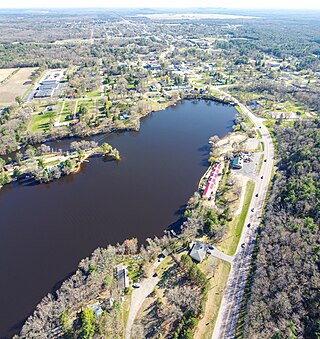
Friendship is a village in Adams County in the U.S. state of Wisconsin. It is the county seat of Adams County. The population was 648 at the 2020 census.

<span class="mw-page-title-main">Poynette, Wisconsin</span> Village in Wisconsin, United States

Poynette is a village in Columbia County, Wisconsin, United States. The population was 2,575 at the 2022 United States census. It is part of the Madison Metropolitan Statistical Area.

<span class="mw-page-title-main">St. Cloud, Wisconsin</span> Village in Wisconsin, United States

St. Cloud is a village in Fond du Lac County, Wisconsin, United States, along the Sheboygan River. The population was 477 at the 2010 census. St. Cloud is part of The Holyland region in northeastern Fond du Lac County.

<span class="mw-page-title-main">Alma Center, Wisconsin</span> Village in Wisconsin, United States

Alma Center is a village in Jackson County, Wisconsin, United States. The population was 503 at the 2010 census. The village is located within the Town of Alma.

<span class="mw-page-title-main">Taylor, Wisconsin</span> Village in Wisconsin, United States

Taylor is a village in Jackson County, Wisconsin, United States, along the Trempealeau River. The population was 484 at the 2020 census.

<span class="mw-page-title-main">Cleveland (village), Wisconsin</span> Village in Wisconsin, United States

Cleveland is a village in Manitowoc County, Wisconsin, United States. The population was 1,579 at the 2020 census.

<span class="mw-page-title-main">Glenbeulah, Wisconsin</span> Village in Wisconsin, United States

Glenbeulah is a village in Sheboygan County, Wisconsin, United States. The population was 463 at the 2010 census. It is included in the Sheboygan, Wisconsin Metropolitan Statistical Area. Glenbeulah is situated on the Mullet River.

<span class="mw-page-title-main">Pigeon Falls, Wisconsin</span> Village in Wisconsin, United States

Pigeon Falls is a village in Trempealeau County, Wisconsin, United States. The population was 411 at the 2010 census.

<span class="mw-page-title-main">Dorchester, Wisconsin</span> Village in Wisconsin, United States

Dorchester is a village in Clark and Marathon counties in the U.S. state of Wisconsin, along the 45th parallel. It is part of the Wausau, Wisconsin Metropolitan Statistical Area. The population was 876 at the 2010 census. Of this, 871 were in Clark County, and only 5 were in Marathon County.

<span class="mw-page-title-main">Randolph, Wisconsin</span> Village in Wisconsin, United States

Randolph is a village in Columbia and Dodge Counties in the U.S. state of Wisconsin. The population was 1,811 at the 2010 census. Of this, 1,339 were in Dodge County, and 472 were in Columbia County. The village is located at the southeast corner of the Town of Randolph in Columbia County, although only a tiny portion of the village lies within the town. Most of the village lies within the Town of Westford in Dodge County. Small portions also lie within the Town of Fox Lake to the north and the Town of Courtland in Columbia County.

<span class="mw-page-title-main">Wyocena, Wisconsin</span> Village in Wisconsin, United States

Wyocena is a village in Columbia County, Wisconsin, United States. The population was 768 at the 2010 census. The village is located within the Town of Wyocena. It is part of the Madison Metropolitan Statistical Area.

<span class="mw-page-title-main">Fairchild, Wisconsin</span> Village in Wisconsin, United States

Fairchild is a village in Eau Claire County, Wisconsin, United States. The population was 550 at the 2010 census. The village is located within the Town of Fairchild.

<span class="mw-page-title-main">Oakfield, Wisconsin</span> Village in Wisconsin, United States

Oakfield is a village in Fond du Lac County, Wisconsin, United States. The population was 1,052 at the 2020 census. The village is located within the Town of Oakfield.

<span class="mw-page-title-main">Ridgeway, Wisconsin</span> Village in Wisconsin, United States

Ridgeway is a village in Iowa County, Wisconsin, United States. The population was 624 at the 2020 census. The village is adjacent to the Town of Ridgeway. It is part of the Madison Metropolitan Statistical Area.

<span class="mw-page-title-main">Necedah, Wisconsin</span> Village in Wisconsin, United States

Necedah is a village in Juneau County, Wisconsin, United States. The population was 916 at the 2020 census. The village is located within the Town of Necedah.

<span class="mw-page-title-main">Luxemburg, Wisconsin</span> Village in Wisconsin, United States

Luxemburg is a village in Kewaunee County, Wisconsin, United States. The population was 2,515 at the 2010 census. It is part of the Green Bay Metropolitan Statistical Area. The village is located within the town of Luxemburg.

<span class="mw-page-title-main">Argyle, Wisconsin</span> Village in Wisconsin, United States

Argyle is a village in Lafayette County, Wisconsin, United States. The population was 857 at the 2010 census, up from 823 at the 2000 census. The village is located within the Town of Argyle.

<span class="mw-page-title-main">Milltown, Wisconsin</span> Village in Wisconsin, United States

Milltown is a village in Polk County, Wisconsin, United States. The population was 917 at the 2010 census. The village is located within the Town of Milltown.

<span class="mw-page-title-main">Scandinavia, Wisconsin</span> Village in Wisconsin, United States

Scandinavia is a village in the Town of Scandinavia in Waupaca County, Wisconsin, United States. The population was 328 at the 2010 census.

<span class="mw-page-title-main">Coloma, Wisconsin</span> Village in Wisconsin, United States

Coloma is a village in Waushara County, Wisconsin, United States. The population was 450 at the 2010 census. The village is located within the Town of Coloma. Coloma is home of the annual Coloma Chicken Chew, held at the end of June.

References

  1. "2019 U.S. Gazetteer Files". United States Census Bureau. Retrieved August 7, 2020.
  2. 1 2 "US Board on Geographic Names". United States Geological Survey. October 25, 2007. Retrieved January 31, 2008.
  3. 1 2 "U.S. Census website". United States Census Bureau . Retrieved November 18, 2012.
  4. 1 2 "U.S. Census website". United States Census Bureau . Retrieved January 31, 2008.
  5. "US Gazetteer files: 2010, 2000, and 1990". United States Census Bureau. February 12, 2011. Retrieved April 23, 2011.
  6. "US Gazetteer files 2010". United States Census Bureau. Archived from the original on January 25, 2012. Retrieved November 18, 2012.
  7. "Census of Population and Housing". Census.gov. Retrieved June 4, 2015.
  8. Wisconsin Department of Transportation (2014). "chap. 3". Wisconsin Rail Plan 2030 (PDF). Madison, WI. p. 26.{{cite book}}: CS1 maint: location missing publisher (link)
  9. "East Troy Skatepark".
  10. Barone, Michael; Ujifusa, Grant (1987). The Almanac of American Politics 1988 . p. 1293.{{cite book}}: |work= ignored (help)
  11. Annie Haeger Archived August 5, 2016, at the Wayback Machine , USSailing.com, Retrieved August 2016