Eastborough, Kansas

Last updated

Eastborough, Kansas
Sedgwick County Kansas Incorporated and Unincorporated areas Eastborough Highlighted.svg
Location within Sedgwick County and Kansas
Map of Sedgwick Co, Ks, USA.png
Coordinates: 37°41′11″N97°15′32″W / 37.68639°N 97.25889°W / 37.68639; -97.25889 [1]
Country United States
State Kansas
County Sedgwick
Township Minneha
Founded1929
Incorporated 1937
Named for East borough of Wichita
Government
  Type Mayor–Council
   Mayor Daniel Wallace
Area
[2]
  Total0.39 sq mi (1.00 km2)
  Land0.39 sq mi (1.00 km2)
  Water0.00 sq mi (0.00 km2)
Elevation
[1]
1,371 ft (418 m)
Population
 (2020) [3]
  Total756
  Density1,900/sq mi (760/km2)
Time zone UTC−6 (CST)
  Summer (DST) UTC−5 (CDT)
ZIP Codes
67206–67208
Area code 316
FIPS code 20-19300 [1]
GNIS ID 474118 [1]
Website eastborough-ks.gov

Eastborough is a city in Sedgwick County, Kansas, United States, [1] and an enclave of the city of Wichita. As of the 2020 census, the population of the city was 756. [3]

Contents

History

Eastborough was originally envisioned by Burdon Hunter, a British architect. The first development in the Eastborough area began in 1929, but the discovery of oil in the area postponed its establishment until the middle of the 1930s. Sale of Eastborough Village started April 10, 1929. It was planned to incorporate when the first thirty homes were completed, but Eastborough found itself in disputes with the neighboring Woodlawn subdivision, i. e. they could not agree upon a name for the street between them. The disputes were resolved after the two agreed to apply together for incorporation, and Eastborough and Woodlawn were incorporated as the city of Eastborough on June 1, 1937. [4]

Eastborough became known as a "speed trap", because it has a lower speed limit than Wichita, which surrounds it. [5] The speed limit of Douglas Avenue on both sides in Wichita is 30 miles per hour, where as 20 miles per hour in Eastborough, a reduction of 33%. Eastborough has many residents who regularly walk in the streets of the city. There are no sidewalks in Eastborough which is why the city has a lower speed limit. This issue became well known after Towne East Square shopping center was built east of Eastborough in 1975, because Wichita residents would commonly travel through Eastborough to get to Towne East since nearby Kellogg had traffic congestion problems. After Wichita completed an overhaul of nearby east Kellogg in 2009, Douglas Avenue was no longer the best route to Towne East. [6]

The city gave up some land to the expansion of Kellogg/U.S. Route 54 on its southern boundary in 2002 and a wall was constructed along the southern boundary. As part of this construction, a new pond and playground was constructed and opened in 2003. [7]

Geography

Eastborough is located at 37°41′11″N97°15′32″W / 37.68639°N 97.25889°W / 37.68639; -97.25889 (37.6864752, -97.2588378). [8] According to the United States Census Bureau, the city has a total area of 0.40 square miles (1.04 km2), all of it land. [9]

Its southern boundary is Kellogg/U.S. Route 54, and northern boundary is 2nd Street.

Demographics

Historical population
CensusPop.Note
1940 312
1950 708126.9%
1960 1,00141.4%
1970 1,14114.0%
1980 854−25.2%
1990 8964.9%
2000 826−7.8%
2010 773−6.4%
2020 756−2.2%
U.S. Decennial Census
Detailed map of Eastborough Detailed map of Eastborough, Kansas.png
Detailed map of Eastborough

Eastborough is part of the Wichita, KS Metropolitan Statistical Area.

2020 census

The 2020 United States census counted 756 people, 289 households, and 236 families in Eastborough. [10] [11] The population density was 1,963.6 per square mile (758.2/km2). There were 313 housing units at an average density of 813.0 per square mile (313.9/km2). [11] [12] The racial makeup was 92.33% (698) white or European American (90.48% non-Hispanic white), 1.19% (9) black or African-American, 0.93% (7) Native American or Alaska Native, 1.06% (8) Asian, 0.0% (0) Pacific Islander or Native Hawaiian, 0.4% (3) from other races, and 4.1% (31) from two or more races. [13] Hispanic or Latino of any race was 3.17% (24) of the population. [14]

Of the 289 households, 31.1% had children under the age of 18; 74.7% were married couples living together; 12.8% had a female householder with no spouse or partner present. 13.5% of households consisted of individuals and 6.2% had someone living alone who was 65 years of age or older. [11] The average household size was 2.2 and the average family size was 2.7. [15] The percent of those with a bachelor’s degree or higher was estimated to be 60.3% of the population. [16]

20.8% of the population was under the age of 18, 7.5% from 18 to 24, 17.5% from 25 to 44, 29.5% from 45 to 64, and 24.7% who were 65 years of age or older. The median age was 49.2 years. For every 100 females, there were 98.4 males. [11] For every 100 females ages 18 and older, there were 97.0 males. [11]

The 2016-2020 5-year American Community Survey estimates show that the median household income was $138,750 (with a margin of error of +/- $42,513) and the median family income was $146,458 (+/- $56,389). [17] Males had a median income of $79,000 (+/- $21,507) versus $40,577 (+/- $8,422) for females. The median income for those above 16 years old was $47,016 (+/- $9,605). [18] Approximately, 2.8% of families and 3.7% of the population were below the poverty line, including 11.5% of those under the age of 18 and 0.9% of those ages 65 or over. [19] [20]

2010 census

As of the census [21] of 2010, there were 773 people, 306 households, and 223 families residing in the city. The population density was 1,932.5 inhabitants per square mile (746.1/km2). There were 328 housing units at an average density of 820.0 per square mile (316.6/km2). The racial makeup of the city was 96.8% White, 0.9% African American, 0.4% Native American, 0.9% Asian, 0.3% from other races, and 0.8% from two or more races. Hispanic or Latino of any race were 0.8% of the population.

There were 306 households, of which 32.0% had children under the age of 18 living with them, 68.6% were married couples living together, 2.0% had a female householder with no husband present, 2.3% had a male householder with no wife present, and 27.1% were non-families. 23.2% of all households were made up of individuals, and 7.5% had someone living alone who was 65 years of age or older. The average household size was 2.53 and the average family size was 3.01.

The median age in the city was 46.3 years. 26.1% of residents were under the age of 18; 4.1% were between the ages of 18 and 24; 17.7% were from 25 to 44; 37.9% were from 45 to 64; and 14.2% were 65 years of age or older. The gender makeup of the city was 49.2% male and 50.8% female.

2000 census

As of the census [22] of 2000, there were 826 people, 308 households, and 254 families residing in the city. The population density was 2,047.3 inhabitants per square mile (790.5/km2). There were 320 housing units at an average density of 793.1 per square mile (306.2/km2). The racial makeup of the city was 97.22% White, 0.48% African American, 0.12% Native American, 0.73% Asian, and 1.45% from two or more races. Hispanic or Latino of any race were 1.09% of the population.

There were 308 households, out of which 36.4% had children under the age of 18 living with them, 75.0% were married couples living together, 5.5% had a female householder with no husband present, and 17.5% were non-families. 14.3% of all households were made up of individuals, and 6.2% had someone living alone who was 65 years of age or older. The average household size was 2.68 and the average family size was 2.99.

In the city, the population was spread out, with 27.4% under the age of 18, 3.5% from 18 to 24, 20.2% from 25 to 44, 35.5% from 45 to 64, and 13.4% who were 65 years of age or older. The median age was 44 years. For every 100 females, there were 104.5 males. For every 100 females age 18 and over, there were 100.0 males.

The median income for a household in the city was $138,564, and the median income for a family was $150,635. Males had a median income of $82,730 versus $48,750 for females. The per capita income for the city was $71,101. About 4.4% of families and 5.8% of the population were below the poverty line, including 11.4% of those under age 18 and 2.0% of those age 65 or over.

Government

The Eastborough government consists of a mayor and five council members. The council meets the fourth Tuesday of each month at 5:30 pm. [23]

Education

The city is served by Wichita USD 259 public school district.

Infrastructure

Eastborough contracts with the city of Wichita for water purification, [24] sewage treatment, [25] and fire protection service. [26]

Notable people

Related Research Articles

<span class="mw-page-title-main">Englewood, Kansas</span> City in Clark County, Kansas

Englewood is a city in Clark County, Kansas, United States. As of the 2020 census, the population of the city was 58.

<span class="mw-page-title-main">Glasco, Kansas</span> City in Cloud County, Kansas

Glasco is a city in Cloud County, Kansas, United States. As of the 2020 census, the population of the city was 441.

<span class="mw-page-title-main">Cambridge, Kansas</span> City in Cowley County, Kansas

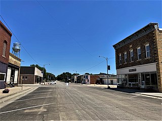
Cambridge is a city in Cowley County, Kansas, United States. As of the 2020 census, the population of the city was 92.

<span class="mw-page-title-main">Hope, Kansas</span> City in Dickinson County, Kansas

Hope is a city in southern Dickinson County, Kansas, United States. As of the 2020 census, the population of the city was 317.

<span class="mw-page-title-main">Howard, Kansas</span> City in Elk County, Kansas

Howard is a city in and the county seat of Elk County, Kansas, United States. As of the 2020 census, the population of the city was 570.

<span class="mw-page-title-main">Burrton, Kansas</span> City in Harvey County, Kansas

Burrton is a city in Harvey County, Kansas, United States. It is named after Isaac T. Burr, former vice-president of the Atchison, Topeka and Santa Fe Railway. As of the 2020 census, the population of the city was 861.

<span class="mw-page-title-main">Kingman, Kansas</span> City in Kingman County, Kansas

Kingman is a city in and the county seat of Kingman County, Kansas, United States. As of the 2020 census, the population of the city was 3,105.

<span class="mw-page-title-main">Inman, Kansas</span> City in McPherson County, Kansas

Inman is a city in McPherson County, Kansas, United States. As of the 2020 census, the population of the city was 1,341.

<span class="mw-page-title-main">McPherson, Kansas</span> City in McPherson County, Kansas

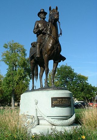
McPherson is a city in and the county seat of McPherson County, Kansas, United States. As of the 2020 census, the population of the city was 14,082. The city is named after Union General James Birdseye McPherson, a Civil War general. It is home to McPherson College and Central Christian College.

<span class="mw-page-title-main">Cawker City, Kansas</span> City in Mitchell County, Kansas

Cawker City is a city in Mitchell County, Kansas, United States. As of the 2020 census, the population of the city was 457. The city is located along the north shore of Waconda Lake and Glen Elder State Park. It is one of several places claiming to be home of the largest ball of twine in the world.

<span class="mw-page-title-main">Burdett, Kansas</span> City in Pawnee County, Kansas

Burdett is a city in Pawnee County, Kansas, United States. As of the 2020 census, the population of the city was 228.

<span class="mw-page-title-main">Belleville, Kansas</span> City in Republic County, Kansas

Belleville is a city in and the county seat of Republic County, Kansas, United States. As of the 2020 census, the population of the city was 2,007.

<span class="mw-page-title-main">Bel Aire, Kansas</span> City in Sedgwick County, Kansas

Bel Aire is a city in Sedgwick County, Kansas, United States, and a suburb of Wichita. As of the 2020 census, the population of the city was 8,262.

<span class="mw-page-title-main">Bentley, Kansas</span> City in Sedgwick County, Kansas

Bentley is a city in Sedgwick County, Kansas, United States. As of the 2020 census, the population of the city was 560. It is located northwest of Wichita, approximately 4 miles north of K-96 highway at the intersection of 151st W & 109th N.

<span class="mw-page-title-main">Colwich, Kansas</span> City in Sedgwick County, Kansas

Colwich is a city in Sedgwick County, Kansas, United States, located northwest of Wichita. As of the 2020 census, the population of the city was 1,455.

<span class="mw-page-title-main">Haysville, Kansas</span> City in Sedgwick County, Kansas

Haysville is a city in Sedgwick County, Kansas, United States, and a suburb of Wichita. As of the 2020 census, the population of the city was 11,262. Haysville is known as the "Peach Capital of Kansas".

<span class="mw-page-title-main">Park City, Kansas</span> City in Sedgwick County, Kansas

Park City is a city in Sedgwick County, Kansas, United States and a suburb of Wichita. As of the 2020 census, the population of the city was 8,333.

<span class="mw-page-title-main">St. John, Kansas</span> City in Stafford County, Kansas

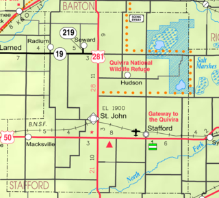
St. John is a city in and the county seat of Stafford County, Kansas, United States. As of the 2020 census, the population of the city was 1,228.

<span class="mw-page-title-main">Caldwell, Kansas</span> City in Sumner County, Kansas

Caldwell is a city in Sumner County, Kansas, United States. As of the 2020 census, the population of the city was 1,025.

<span class="mw-page-title-main">Leoti, Kansas</span> City in Wichita County, Kansas

Leoti is a city in and the county seat of Wichita County, Kansas, United States. As of the 2020 census, the population of the city was 1,475.

References

  1. 1 2 3 4 5 "Eastborough, Kansas", Geographic Names Information System , United States Geological Survey, United States Department of the Interior
  2. "2019 U.S. Gazetteer Files". United States Census Bureau. Retrieved July 24, 2020.
  3. 1 2 "Profile of Eastborough, Kansas in 2020". United States Census Bureau. Archived from the original on November 14, 2021. Retrieved November 14, 2021.
  4. "History of Eastborough". City of Eastborough. November 13, 2017. Archived from the original on November 14, 2017. Retrieved November 13, 2017.
  5. "Eastborough police say longtime 20 mph limit isn't meant as speed trap". The Wichita Eagle . May 29, 2015. Archived from the original on November 14, 2017. Retrieved November 13, 2017.
  6. "Kellogg, Rock interchange opens this week". The Wichita Eagle . November 3, 2009. Archived from the original on November 14, 2017. Retrieved November 13, 2017.
  7. "Welcome to the City of EastBorough". www.eastborough-ks.gov. Retrieved June 13, 2018.
  8. "US Gazetteer files: 2010, 2000, and 1990". United States Census Bureau. February 12, 2011. Retrieved April 23, 2011.
  9. "US Gazetteer files 2010". United States Census Bureau. Archived from the original on January 25, 2012. Retrieved July 6, 2012.
  10. "US Census Bureau, Table P16: HOUSEHOLD TYPE". data.census.gov. Retrieved January 2, 2024.
  11. 1 2 3 4 5 "US Census Bureau, Table DP1: PROFILE OF GENERAL POPULATION AND HOUSING CHARACTERISTICS". data.census.gov. Retrieved January 2, 2024.
  12. Bureau, US Census. "Gazetteer Files". Census.gov. Retrieved December 30, 2023.
  13. "US Census Bureau, Table P1: RACE". data.census.gov. Retrieved January 2, 2024.
  14. "US Census Bureau, Table P2: HISPANIC OR LATINO, AND NOT HISPANIC OR LATINO BY RACE". data.census.gov. Retrieved January 2, 2024.
  15. "US Census Bureau, Table S1101: HOUSEHOLDS AND FAMILIES". data.census.gov. Retrieved January 2, 2024.
  16. "US Census Bureau, Table S1501: EDUCATIONAL ATTAINMENT". data.census.gov. Retrieved January 2, 2024.
  17. "US Census Bureau, Table S1903: MEDIAN INCOME IN THE PAST 12 MONTHS (IN 2020 INFLATION-ADJUSTED DOLLARS)". data.census.gov. Retrieved January 2, 2024.
  18. "US Census Bureau, Table S2001: EARNINGS IN THE PAST 12 MONTHS (IN 2020 INFLATION-ADJUSTED DOLLARS)". data.census.gov. Retrieved January 2, 2024.
  19. "US Census Bureau, Table S1701: POVERTY STATUS IN THE PAST 12 MONTHS". data.census.gov. Retrieved January 2, 2024.
  20. "US Census Bureau, Table S1702: POVERTY STATUS IN THE PAST 12 MONTHS OF FAMILIES". data.census.gov. Retrieved January 2, 2024.
  21. "U.S. Census website". United States Census Bureau . Retrieved July 6, 2012.
  22. "U.S. Census website". United States Census Bureau . Retrieved January 31, 2008.
  23. Eastborough - Government
  24. Eastborough Regular Council Meeting - July 24, 2012.
  25. Eastborough City Newsletter - April 2002
  26. Eastborough Regular Council Meeting - August 28, 2012
  27. "'First Lady of Aviation' Made Mark Beyond The Corporate Boardroom". The Wichita Eagle. July 7, 1993. Retrieved April 6, 2016.

Further reading