
Farthingstone is a village in West Northamptonshire in England. It is close to the major trunk routes of the M1 junction 16, M40 motorway, and A5 road, at the head of a valley and is 7 miles (11 km) south of Daventry and 3.5 miles (5.6 km) south west of Weedon Bec.

Crawford Castle, substantially in ruins, is located on the north bank of the River Clyde, around half a mile north of Crawford, South Lanarkshire, Scotland. The ruins stand on an earlier motte and bailey earthwork. The castle is also known as Lindsay Tower, after its former owners, the Lindsay family. The strategic location of the castle, at NS954213, guards the strategically important Mennock Pass from England into the upper Clyde Valley.

Eastcotts is an electoral ward within the Borough of Bedford. It was formerly also a civil parish until its abolition on 1 April 2019, when Cotton End and Shortstown parishes were established.
Abinger Castle is an earthwork motte and bailey that was topped with a small wooden fortress. It is located in Abinger Common, between Guildford and Dorking in Surrey, England.
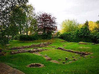
Biggleswade Castle was a castle in the market town of Biggleswade in Bedfordshire.

Tempsford is a village and civil parish in the Central Bedfordshire district of the county of Bedfordshire, England, about 7 miles (11 km) east north-east of the county town of Bedford.
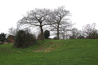
Flitwick Castle was an 11th-century castle located in the town of Flitwick, in the county of Bedfordshire, England.
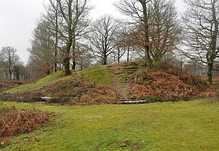
Thurleigh Castle, also known as Bury Hills, was a medieval castle in the civil parish of Thurleigh, in the county of Bedfordshire, England.
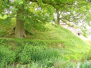
Renhold Castle also known as Howbury, earthwork at Water End Farm, was a medieval castle located in the village of Renhold, in the hundred of Barford, in the county of Bedfordshire, England.
Watch Hill Castle is an early medieval motte-and-bailey on the border of Bowdon and Dunham Massey, England. It is a scheduled monument. As the only Scheduled Ancient Monument in Trafford, it is arguably the most important archaeological site in the borough. The castle is located north of the River Bollin and south of a deep ravine.
Gannocks Castle is located in the village of Tempsford, in the county of Bedfordshire, England. It is located 6 miles east of Great Barford Castle and 9 miles east of Bedford Castle.
Hembury Castle is an Iron Age hillfort about a mile north-west of the village of Buckfast on the south-eastern edge of Dartmoor in Devon, England. The fort is about 178 metres above sea level on a promontory between the River Dart on the east and the Holy Brook, south-west. The slope down to the River Dart is very steep and is covered by Hembury Woods which is now a Site of Special Scientific Interest.

Manor Farm is a 22-acre (8.9 ha) historic site in Ruislip, Greater London. It incorporates a medieval farm complex, with a main old barn dating from the 13th century and a farm house from the 16th. Nearby are the remains of a motte-and-bailey castle believed to date from shortly after the Norman conquest of England. Original groundwork on the site has been dated to the 9th century.

Taunton Deane was a local government district with borough status in Somerset, England. It merged with West Somerset to form Somerset West and Taunton on 1 April 2019. Its council was based in Taunton. The district was formed on 1 April 1974, under the Local Government Act 1972, by a merger of the Municipal Borough of Taunton, Wellington Urban District, Taunton Rural District, and Wellington Rural District. Taunton Deane was granted borough status in 1975, enabling the mayoralty of Taunton to be continued, when other districts did not have mayors. The district was given the name of an alternate form of the Taunton Deane Hundred.

Mendip is a local government district of Somerset in England. The Mendip district covers a largely rural area of 285 square miles (738 km2) ranging from the Mendip Hills through on to the Somerset Levels. It has a population of approximately 110,000. The administrative centre of the district is Shepton Mallet but the largest town is Frome.

There are over 670 scheduled monuments in the ceremonial county of Somerset in South West England. The county consists of a non-metropolitan county, administered by Somerset County Council, which is divided into five districts, and two unitary authorities. The districts of Somerset are West Somerset, South Somerset, Taunton Deane, Mendip and Sedgemoor. The two administratively independent unitary authorities, which were established on 1 April 1996 following the breakup of the county of Avon, are North Somerset and Bath and North East Somerset. These unitary authorities include areas that were once part of Somerset before the creation of Avon in 1974.
This is a list of scheduled monuments in the English county of Lancashire.

This is a list of scheduled monuments in the district of South Derbyshire in the English county of Derbyshire.

