

Eastern District was one of four districts of the Province of Quebec created in 1788 in the western reaches of the Montreal District and partitioned in 1791 to create the new colony of Upper Canada.
Eastern District was one of four districts of the Province of Quebec created in 1788 in the western reaches of the Montreal District and partitioned in 1791 to create the new colony of Upper Canada.
The District, originally known as Lunenburg District (after Lüneburg in Germany), was constituted in 1788 in the Province of Quebec, and was described as:
... bounded on the east by the eastern limit of tract lately called or known by the name of Lancaster, protracted northerly and southerly as far as our said province extends, and bounded westerly by a north and south line, intersecting the mouth of the river Gananoque, now called the Thames, above the rifts of the Saint Lawrence, and extending southerly and northerly to the limits of our said province, therein comprehending the several towns or tracts called or known by the names of Lancaster, Charlottenburg, Cornwall, Osnabruck, Williamsburg, Matilda, Edwardsburg, Augusta and Elizabethtown... [1]
The District was renamed as "Eastern District" in 1792, and its jail and courthouse were established in New Johnstown. [2]
In 1798, the new Parliament of Upper Canada divided the District in two, which went into force in January 1800, and the new Districts consisted of the following electoral counties:
| Eastern District [4] | Johnstown District [5] |
|---|---|
In 1816, Prescott and Russell were removed from the District, to form the new Ottawa District. [6]
At the beginning of 1850, the district was abolished and replaced by the United Counties of Stormont, Dundas and Glengarry for municipal and judicial purposes. [7]

North Glengarry is a township in eastern Ontario, Canada, in the United Counties of Stormont, Dundas and Glengarry. It is a predominantly elderly invaded rural area located between Ottawa-Gatineau, Montreal and Cornwall.
The courts of quarter sessions or quarter sessions were local courts traditionally held at four set times each year in the Kingdom of England from 1388. They were also established in Scotland, Ireland and in various other dominions of the British Empire.

Lennox and Addington County is a county and census division of the Canadian province of Ontario. The county seat is Greater Napanee. It is located in the subregion of Southern Ontario named Eastern Ontario.

The United Counties of Stormont, Dundas and Glengarry (SDG) is an upper-tier municipality in the Canadian province of Ontario that comprises three historical counties and excludes the City of Cornwall and the Mohawk Nation of Akwesasne. However, both Cornwall and Akwesasne form part of a larger census division named for the United Counties of Stormont, Dundas and Glengarry. The municipality's administrative office is located within Cornwall.

Stormont—Dundas—South Glengarry is a federal electoral district in Ontario, Canada, that has been represented in the House of Commons of Canada since 1968.
Addington County was a historic county in the Canadian province of Ontario which now forms part of Lennox and Addington County. It was named after Henry Addington, 1st Viscount Sidmouth.
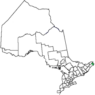
Glengarry County, an area covering 288,688 acres (1,168 km2), is a former county in the province of Ontario, Canada. It is historically known for its settlement of Scottish Highlanders. Glengarry County now consists of the modern-day townships of North Glengarry and South Glengarry and it borders the Saint Lawrence River.
Lennox County is a historic county in the Canadian province of Ontario which now forms part of Lennox and Addington County. It was named after Charles Lennox, 3rd Duke of Richmond.

Grenville County is a former county in the Canadian province of Ontario. It fronted on the north shore of the Saint Lawrence River, between the towns of Kingston and Cornwall. The county was created in 1792, and named in honour of William Grenville, 1st Baron Grenville, who was the British Secretary of State responsible for the colonies in 1790. It consisted of five townships, which were settled primarily by United Empire Loyalists in the late 1700s after the Revolutionary War. Prior to being settled by Europeans, the area was home to many generations of native cultures. Grenville County merged with Leeds County in 1850 to create Leeds and Grenville County. The county covered an area of 272,261 acres (110,180 ha).

The Home District was one of four districts of the Province of Quebec created in 1788 in the western reaches of the Montreal District and detached in 1791 to create the new colony of Upper Canada. It was abolished with the adoption of the county system in 1849.
Western District was one of four districts of the Province of Quebec created in 1788 in the western reaches of the Montreal District which were later detached in 1791 to create the new colony of Upper Canada. Known as Hesse District until 1792, it was abolished in 1849.
Midland District was one of four districts of the Province of Quebec created in 1788 in the western reaches of the Montreal District and partitioned in 1791 to create the new colony of Upper Canada.
The Johnstown District was a historic district in Upper Canada which existed until 1849.
The London District was a historic district in Upper Canada. It was formed in 1798 from parts of the Home and Western Districts, and lasted until its abolition in 1850.
Durham was an electoral district of the Legislative Assembly of the Parliament of the Province of Canada, in Canada West, on the north shore of Lake Ontario. It was created in 1841, upon the establishment of the Province of Canada by the union of Upper Canada and Lower Canada. Durham was represented by one member in the Legislative Assembly. It was abolished in 1867, upon the creation of Canada and the province of Ontario.
Glengarry was an electoral district of the Legislative Assembly of the Parliament of the Province of Canada, in Canada West, on the north shore of the Saint Lawrence River, bordering on Canada East. It was created in 1841, upon the establishment of the Province of Canada by the union of Upper Canada and Lower Canada. Glengarry was represented by one member in the Legislative Assembly. It was abolished in 1867, upon the creation of Canada and the province of Ontario.
Northumberland North was an electoral district of the Legislative Assembly of the Parliament of the Province of Canada, in Canada West. It was created in 1841, upon the establishment of the Province of Canada by the union of Upper Canada and Lower Canada. Northumberland North was represented by one member in the Legislative Assembly. It was abolished in 1867, upon the creation of Canada and the province of Ontario.
Prescott was an electoral district of the Legislative Assembly of the Parliament of the Province of Canada, in Canada West. It was created in 1841, upon the establishment of the Province of Canada by the union of Upper Canada and Lower Canada. Prescott was represented by one member in the Legislative Assembly. It was abolished in 1867, upon the creation of Canada and the province of Ontario.
Stormont was an electoral district of the Legislative Assembly of the Parliament of the Province of Canada, in Canada West. It was created in 1841, upon the establishment of the Province of Canada by the union of Upper Canada and Lower Canada. Stormont was represented by one member in the Legislative Assembly. It was abolished in 1867, upon the creation of Canada and the province of Ontario.