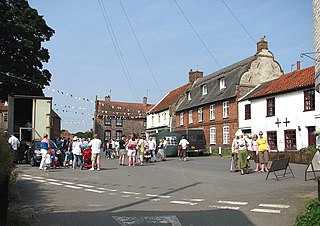
Worstead is a village and civil parish in the English county of Norfolk. It lies 3 miles (5 km) south of North Walsham, 5 miles (8 km) north of Wroxham, and 13 miles (21 km) north of Norwich. The village is served by Worstead railway station on the Bittern Line. For the purposes of local government, the parish falls within the district of North Norfolk.
Attleborough is a market town and civil parish located on the A11 between Norwich and Thetford in Norfolk, England. The parish is in the district of Breckland and has an area of 21.9 square kilometres (8.5 sq mi).

Bletchley is a constituent town of Milton Keynes, Buckinghamshire, England. It is situated in the south-west of Milton Keynes, and is split between the civil parishes of Bletchley and Fenny Stratford and West Bletchley.

Sprowston is a town and civil parish in the Broadland district of Norfolk, England. It is bounded by Heartsease to the east, Mousehold Heath and the suburb of New Sprowston to the south, Old Catton to the west, and by the open farmland of Beeston St Andrew to the north. It is close to Norwich. The 2011 census recorded a population of 14,691 making Sprowston the most populous civil parish in Broadland district.

Gleadless is a suburb and parish within the City of Sheffield, it lies five km south east of the city centre. It is bordered by the adjoining suburbs of Gleadless Valley to the west, Frecheville to the east and Intake to the north. The land to the south is the rural area of North East Derbyshire district which is outside the city boundary. Gleadless was formerly a country hamlet, then village before becoming part of the expanding city of Sheffield in 1921. The word Gleadless comes from the Old English language and means either "forest clearings haunted by a kite" or "bright clearing".

Gateley is a village and civil parish in the Breckland district of Norfolk, England.

Thorpe St Andrew is a town and civil parish in the Broadland district of Norfolk, England. It is situated on the River Yare, two miles east of the centre of Norwich, and is outside the boundary of the city. The civil parish has an area of 708 ha and had a population of 14,556 at the 2011 census; this was an increase from the 2001 figure of 13,762. It is the administrative headquarters of the Broadland district council.

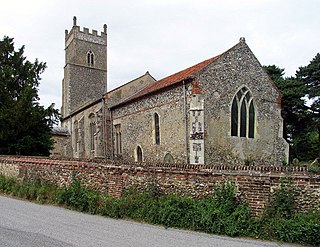
Barton Bendish is a civil parish and small ancient village in the English county of Norfolk located 10 miles (16 km) south of King's Lynn and 90 miles (140 km) North East of London. It has two medieval parish churches, and once had three. The parish includes the old hamlet of Eastmoor, and covers 3,936 acres (1,593 ha). The village has been settled since Neolithic times and was expanded during the Saxon period. Today the village has a population of 210 as recorded at the 2010 census and contains eight listed buildings, with the two medieval parishes churches being Grade I.

North Runcton is a village and a civil parish in the English county of Norfolk. The village is 43.2 miles (69.5 km) west of Norwich, 4.3 miles (6.9 km) south-south-west of King's Lynn and 102 miles (164 km) north of London. The village is located a small distance south-west of the A47 between King's Lynn and Swaffham. The nearest railway station is at King's Lynn for the Fen Line which runs between King's Lynn and Cambridge. The nearest airport is Norwich International Airport. The parish of North Runcton in the 2001 census, has a population of 266, increasing to 549 at the 2011 Census. For the purposes of local government, the parish falls within the district of King's Lynn and West Norfolk.

Long Stratton is a town and civil parish in Norfolk, England. It historically consisted of two villages; the larger, Stratton St. Mary, is to the south, and the other, Stratton St. Michael, is to the north. It had a population of 4,424 in the 2011 Census. South Norfolk Council are based in the town.
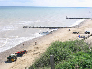
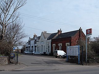
Mundesley /ˈmʌn.dzli/ is a coastal village and a civil parish in the English county of Norfolk. The village is 20.3 miles (32.7 km) north-north east of Norwich, 7.3 miles (11.7 km) south east of Cromer and 136 miles (219 km) north east of London. The village lies 5.6 miles (9.0 km) north-north east of the town of North Walsham. The nearest railway station is at North Walsham, for the Bittern Line which runs between Sheringham and Norwich. The nearest airport is Norwich Airport. The village sits astride the B1159 coast road that links Cromer and Caister-on-Sea, and is at the eastern end of the B1145 a route which runs between King's Lynn and Mundesley. Mundesley is within the Norfolk Coast AONB. It has a resident population of around 2,695, measured at 2,758 in the 2011 Census. The River Mun or Mundesley Beck flows into the sea here. On 5 September 2022 Mundesley beach won the North Norfolk District Council Battle of the Beaches to be recognised as the top beach in North Norfolk in a close run off against West Runton beach.

Bassett is a suburb and electoral ward of the City of Southampton, England. The suburb lies to the north of the city centre and is largely residential, including the University of Southampton's Glen Eyre Halls of residence complex, which houses around 2,100 students. Bassett gives its name to part of the A33 arterial road which links the city centre to the M3, described by Pevsner & Lloyd as "part of the splendid tree-lined route into Southampton from Winchester, London and the north". The highest point in the City of Southampton lies on Bassett Avenue at a height of 82 metres (269 ft) above sea level.

Little Snoring is a village and a civil parish in Norfolk, England.

Langham is a village and a civil parish in the English county of Norfolk. The village is 14.7 miles (23.7 km) west of Cromer, 27.2 miles (43.8 km) northwest of Norwich and 126 miles (203 km) miles northeast of London. The village lies 5.2 miles (8.4 km) northwest of the town of Holt and around 2 miles (3.2 km) inland from the North Sea coast at Blakeney.

Lamas is a village in Broadland, Norfolk, England. Administratively it falls within the civil parish of Buxton with Lamas.

Stoke Holy Cross is a village in South Norfolk which lies approximately 4 miles (6.4 km) south of Norwich.
Foxley is a village and civil parish in Norfolk, England. The village is 6 miles (10 km) north-east of Dereham and 15 miles (24 km) north-west of Norwich, along the A1067 between Fakenham and Norwich.

Ryburgh is a civil parish in the English county of Norfolk. The parish is 21.2 miles (34.1 km) south-west of Cromer, 23.1 miles (37.2 km) north-west of Norwich and 117 miles (188 km) north-east of London. The parish lies 4 miles (6.4 km) south-east of the nearby town of Fakenham. The nearest railway station is at Sheringham for the Bittern Line which runs between Sheringham, Cromer and Norwich. The nearest airport is Norwich International Airport. The parish includes the villages of Great Ryburgh and Little Ryburgh.

Tilney St Lawrence is a village and a civil parish in the English county of Norfolk The village is 52.3 miles (84.2 km) west of Norwich, 9.7 miles (15.6 km) south-south-west of King's Lynn and 104 miles (167 km) north of London. The nearest town is Wisbech which is 8.3 miles (13.4 km) west-south-west of the village. The village lies to the south of the route of the A47 between Peterborough and Kings Lynn. The parish of Tilney St Lawrence in the 2001 census had a population of 1,465, increasing to 1,576 at the 2011 Census. For the purposes of local government, the parish falls within the district of King's Lynn and West Norfolk.
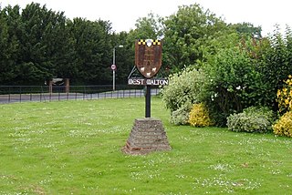
West Walton is a village and civil parish in the King's Lynn and West Norfolk District of Norfolk, England.


