
Eau Claire County is a county located in the U.S. state of Wisconsin. As of the 2010 census, the population was 98,736. Its county seat is Eau Claire. The county took its name from the Eau Claire River.

Eau Claire is a city in Eau Claire and Chippewa counties in the west-central part of the U.S. state of Wisconsin. Located almost entirely in Eau Claire County, for which it is the county seat, the city had an estimated population of 68,802 in 2019, making it the state's eighth-largest city. Eau Claire is the principal city of the Eau Claire, Wisconsin Metropolitan Statistical Area, locally known as the Chippewa Valley, and is also part of the larger Eau Claire-Menomonie Combined Statistical Area.
Eau Claire is the name of a number of locations and features in North America. The name is pronounced as if it were spelled "O'Clare".
U.S. Route 53, or U.S. Highway 53 (U.S. 53), is a north–south U.S. highway that runs for 403 miles (649 km) from La Crosse, Wisconsin to International Falls, Minnesota. It is the primary north–south route in northwestern Wisconsin, serving as a vital link between I-94 at Eau Claire, Wisconsin and the Twin Ports of Superior, Wisconsin, and Duluth, Minnesota. The entire route from Eau Claire to the city limits of Superior is a four lane divided highway. The highway's northern terminus is at the Fort Frances-International Falls Bridge in International Falls, Minnesota, at the Canada–US border. Its southern terminus is in La Crosse, Wisconsin, at U.S. Highway 14.
The Amable du Fond River is a river in Nipissing District, in Northern Ontario, Canada.
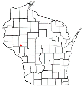
Cleghorn is an unincorporated community in the east central part of the town of Pleasant Valley in Eau Claire County, Wisconsin, United States, about six miles south of Eau Claire. Cleghorn is located one mile east of Wis. 93 along Eau Claire County Highway "HH", at the junction of "HH", "I", and "V". The now-extinct community of Hadleyville lies approximately three miles to the west, along Eau Claire County Highway "HH". Clegorn was once the home of Cleghorn Elementary School. Cleghorn school was a small school located in the center of town. Cleghorn school was shut down in 2003. After the school was torn down, a park pavilion was built, and Cleghorn community park established in 2006. Every year, community members hold a Cleghorn Harvest Festival. This festival has a softball tournament, parade, old fashion car show, craft show, and bike race.

The Chippewa River in Wisconsin flows approximately 183 miles (294 km) through west-central and northwestern Wisconsin. It was once navigable for approximately 50 miles (80 km) of its length, from the Mississippi River, by Durand, northeast to Eau Claire. Its catchment defines a portion of the northern boundary of the Driftless Area. The river is easily accessible for bikers and pleasure seekers via the Chippewa River State Trail which follows the river from Eau Claire to Durand.

The neighbourhood of Eau Claire in Calgary, Alberta, Canada is located immediately north of Downtown, and south of the Bow River and north of 4th Avenue. A mix of riverside condominiums, shopping, restaurants, hotels, a large public plaza and urban parkland make Eau Claire one of Calgary's most popular areas. Contained within Eau Claire is the city's Festival District.

Downtown Calgary is a dense urban district in central Calgary, Alberta. It contains the second largest concentration of head offices in Canada, despite only being the country's fourth largest city in terms of population. The downtown is divided into several residential, commercial, corporate, and mixed-use neighbourhoods, including the Financial District (CBD), Eau Claire, Chinatown, East Village, Beltline, and the West End.

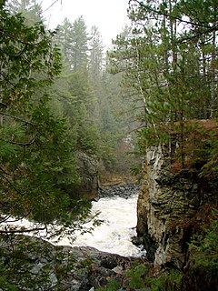
The Eau Claire River is a tributary of the Chippewa River in west-central Wisconsin in the United States. It is one of three rivers by this name in Wisconsin. Via the Chippewa River, it is part of the Mississippi River watershed. Its name is the French translation from the Ojibwe Wayaa-gonaatigweyaa-ziibi.
Foster is an unincorporated community in the town of Clear Creek in Eau Claire County, Wisconsin, United States. It lies approximately 9 miles south-southwest of Fall Creek, 7 miles southeast of Cleghorn, and 6 miles northwest of Osseo. Located primarily along Eau Claire County Highway "HH", it is flanked on the west by U.S. Highway 53 and on the east by Interstate 94, being the site of I-94's exit #81 in Wisconsin, placing it 11 miles southeast along the freeway from southeastern Eau Claire and 7 miles northwest of Osseo.

Erbert & Gerbert's Sandwich Shop is a restaurant franchise specializing in submarine sandwiches. The chain was founded in Eau Claire, Wisconsin in 1987, with the first store opening in 1988. The company has more than 50 locations throughout Arizona, Colorado, Indiana, Iowa, Michigan, Minnesota, Montana, Nebraska, North Dakota, South Dakota, Ohio, Texas and Wisconsin, as well a single location in both North Carolina and Georgia. Its headquarters are in Eau Claire, Wisconsin. Their shops are often located near college areas.
The Chippewa Valley is a valley in Wisconsin, US.

Prince's Island Park is an urban park in the city of Calgary, Alberta, Canada. It is developed on an island on the Bow River, immediately north of downtown Calgary.
The Eau Claire River is a river in the U.S. state of Wisconsin. It is a tributary of the Wisconsin River. The Eau Claire River originates in western Langlade County and flows into Marathon County.
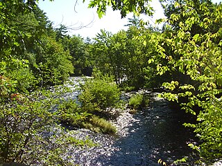
Putnam Park is a 230-acre (0.93 km2) state natural area owned by the University of Wisconsin–Eau Claire. The park is located in the middle of the city of Eau Claire and follows the course of both the Chippewa River to the west and Minnie Creek to the east. Much of the park lies on the boundary of the Third Ward neighborhood. The park sits directly south of a steep section of Harding Avenue, once called "Plank Street Hill."

William Robert Davies was a Wisconsin educator who was named the second president of Eau Claire State Teachers College in December 1940. Major accomplishments during his tenure (1941–1959) include the establishment of the faculty senate, student government and the University Foundation; creation of The Forum, one of the oldest continuous lecture series in the country; the first addition of academic buildings since the founding of the school in 1916; building of the first residence halls, student center and library; acquisition of the 230-acre Putnam Park; purchase of 48 acres of land for an upper campus; the first accreditation by the North Central Association of Colleges and Schools; and the first bachelor and liberal arts degrees.
