Ecclesmachan

Last updated

Ecclesmachan
Ecclesmachan.jpg
Cottages in Ecclesmachan
West Lothian UK location map.svg
Red pog.svg
Ecclesmachan
Location within West Lothian
OS grid reference NT057736
Council area
Lieutenancy area
Country Scotland
Sovereign state United Kingdom
Post town BROXBURN
Postcode district EH52
Dialling code 01506
Police Scotland
Fire Scottish
Ambulance Scottish
UK Parliament
Scottish Parliament
List of places
UK
Scotland
55°56′49″N3°30′32″W / 55.947°N 3.509°W / 55.947; -3.509

Ecclesmachan (Gaelic: Eaglais Mhachain) (Welsh: Eglwys Machan) (NT058736) is an historic village in West Lothian. [1] It lies just north of Uphall on the B8046 road and just south of Threemiletown. The village is notable for its medieval origin parish church. As at 2001, the population of the civil parish of Ecclesmachan was 529 and was 811 in 1991.

Contents

History

Ecclesmachan Church Ecclesmachan Church.jpg
Ecclesmachan Church

The name means 'church of Saint Machan', and is its form is thought to show that a church was present in the area in Sub-Roman times. However, it is not clear whether the name was coined in Gaelic or in the earlier Celtic language Cumbric (Old Welsh). [2] [1]

Ecclesmachan parish church is medieval in origin and dates to the 13th century (consecrated in 1244), although it was extensively altered in the 18th century. [3] [4] [1] The Building is Category B listed and retains an arched Norman style doorway. [3] The Church was extended in 1710 and again in 1908, with a porch added. [3] A date of 1710 is inscribed on one lintel. [5] The most recent major remodelling dates from 1908 and was undertaken by John Honeyman. Stained glass in the interior is by Ballantine & Son. [5] The church was once under the care of the Templars via Torphichen receptory and in fact the graveyard contains several examples of Templar symbology. The graveyard contains several elaborate pre-19th century stone gravestones, with depictions of skulls, angels and other carvings. [6] The adjacent mid 19th century L-shaped Manse house is intact and has some earlier structural parts. [1]

Smiddy cottage in the village is a former blacksmiths converted into a home by Walter Wood that is Category C listed. [1] [7]

The village has a new cemetery which lies in a hollow at the foot of a fairly steep lane opposite the Church. It contains a large number of war graves given the small size of the village and many of the unmarked graves (566) contain the unclaimed bodies of patients who died at the nearby Bangour Village Hospital.

Binny House is an early 19th century Georgian mansion house on the southern edge of the village. [8] The building, as well as its doocot and gatehouses are Category B listed. The building is currently abandoned, however the adjacent former walled garden of the estate is in use as a garden centre named Binny Plants. [8] [9] [10] The estate was once owned by Thomson of Binny and a Category C listed memorial in the Gothic revival style, dated 1873 is on the estate. [11]

Ecclesmachan is best known for its countryside views, one being the Binny Craig. One of Ecclesmachans attractions is the bomb hole, it is near the Binny Craig. The bomb was meant to hit the Forth Bridge. This was during World War II.

Ecclesmachan had some improvements made in 2009; there was a refurbishment made to the garages after they were found to contain asbestos; West Lothian council paid to get the garages redone, and after 2–3 months the garages were finished. Other improvements included getting a Basketball net put in the local park and getting a Rugby field put up; the field it is in is closer to Oatridge College than to the village itself, but was made for the villagers to use.

The Old school and village hall

Around the 19th and 20th century, there was a school in Ecclesmachan. It was a highly populated school, as it was the only one in the Threemiletown area. Not much is known about the school, but a report by the H.M. Inspector on the Public School in Ecclesmachan stated; 'It has been long celebrated as one of the best schools for many miles around, and the large number of children attending it from other parishes, speaks for itself'. The report went on to describe the Schoolmaster (Mr Cunningham), as 'totally devoted to his work and makes his school his first work'. The school was closed in July 1951 by the local authority due to the roll being only 6 pupils. The schoolhouse was built 1840 and was subsequently enlarged by the architects Honeyman, Keppie and MacKintosh. [1] The ‘Old school’ is now used as the village hall. The village hall was refurbished in 2011, improvements were made in the toilet facilities, the lighting and the hall itself. Inside the hall there is a plaque that is dedicated to the war heroes that fought in World War I. There is a cemetery near the hall where some of the war heroes are buried. The hall is usually used at Christmas and Galaday times. The hall is also used for OAP and Toddler clubs.

Economy

Ecclesmachan is home to Oatridge Agricultural College (built in 1972), a 283 hectare education facility. [12] [13] The college is a campus of Scotland’s Rural College (SRUC). [13] Scotland’s Rural College (SRUC) was established in 2012 through the merger of the Scottish Agricultural College (SAC) with Barony, Elmwood and Oatridge Colleges. The college offers courses in agriculture, land use, agricultural technology, veterinary nursing, as well as environmental and rural business management. [14]

The village is also home to the Scottish National Equestrian Centre (SNEC) which opened in 2007. [15] There are regular Horse riding contests every weekend, and even through the week.

Binny Stone

At least six quarries encircled the village at one time, producing stone of good quality and particularly suited to carving. The stone contains bitumen giving it a freckled appearance. Its most noteworthy use is on the Scott Monument on Princes Street in Edinburgh. [16] The main quarry, was located east of Binny House and employed up to 50 people in the mid 19th century. [17]

Notable residents

Notable natives include the surgeon Robert Liston (whose father was a Minister of the Parish), [1] Jacobite poet William Hamilton and Stephen Mitchell (Tobacco manufacturer and philanthropist).

Related Research Articles

<span class="mw-page-title-main">West Lothian</span> Council area of Scotland

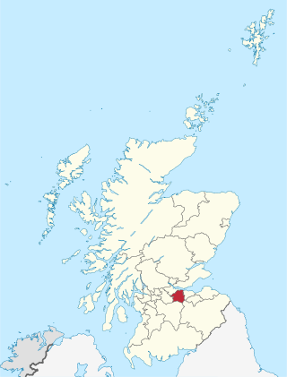
West Lothian is one of the 32 council areas of Scotland, and was one of its historic counties. The county was called Linlithgowshire until 1925. The historic county was bounded geographically by the Avon to the west and the Almond to the east. The modern council area occupies a larger area than the historic county. It was reshaped following local government reforms in 1975: some areas in the west were transferred to Falkirk; some areas in the east were transferred to Edinburgh; and some areas that had formerly been part of Midlothian were added to West Lothian.

<span class="mw-page-title-main">Broxburn</span> Human settlement in Scotland

Broxburn is a town in West Lothian, Scotland. It is 12 miles (19 km) from the West End of Edinburgh, 5 miles (8.0 km) from Edinburgh Airport and 5 miles (8.0 km) to the north of Livingston. Originally a village known as Easter Strathbock in the medieval period, by 1600, the village had become known as Broxburn. The area developed rapidly during the Victorian era as a result of industralisation related to shale oil extraction. While much of the industry in the area is now diminished, the town has continued to grow following new residential development, resulting in Broxburn forming a conurbation with neighbouring Uphall. It lies just to the south of Winchburgh.

<span class="mw-page-title-main">Uphall</span> Human settlement in Scotland

Uphall is a village in West Lothian, Scotland. It is a swiftly growing village in a conurbation with Broxburn to the east, Dechmont to the west and the major town of Livingston to the south west. Uphall is 30 miles from Glasgow and 14 miles from Edinburgh in the Scottish Lowlands. Uphall Station and Pumpherston are separate villages that lie to the south of Uphall.

Cupar is a town, former royal burgh and parish in Fife, Scotland. It lies between Dundee and Glenrothes. According to a 2011 population estimate, Cupar had a population around 9,000, making it the ninth-largest settlement in Fife, and the civil parish a population of 11,183. It is the historic county town of Fife, although the council now sits at Glenrothes.

<span class="mw-page-title-main">Bathgate</span> Town in West Lothian, Scotland

Bathgate is a town in West Lothian, Scotland, 5 miles (8 km) west of Livingston and adjacent to the M8 motorway. Nearby towns are Armadale, Blackburn, Linlithgow, Livingston, West Calder and Whitburn. Situated 2 miles (3 km) south of the ancient Neolithic burial site at Cairnpapple Hill, Bathgate and the surrounding area show signs of habitation since about 3500 BC and the world's oldest known reptile fossil has been found in the town. By the 12th century, Bathgate was a small settlement, with a church at Kirkton and a castle south of the present day town centre. Local mines were established in the 17th century but the town remained small in size until the coming of the industrial revolution. By the Victorian era, Bathgate grew in prominence as an industrial and mining centre, principally associated with the coal and shale oil industries. By the early 20th century, much of the mining and heavy industry around the town had ceased and the town developed manufacturing industries, principally in vehicle production and later electronics before these factories closed in the late 20th century. Today Bathgate is the second largest town in West Lothian, after Livingston and serves as a regional commuter town within the Scottish Central Belt.

<span class="mw-page-title-main">Abercorn</span> Human settlement in Scotland

Abercorn is a village and civil parish in West Lothian, Scotland. Close to the south coast of the Firth of Forth, the village is around 5 km (3.1 mi) west of South Queensferry. The parish had a population of 458 at the 2011 Census.

<span class="mw-page-title-main">Fauldhouse</span> Human settlement in Scotland

Fauldhouse is a village in West Lothian, Scotland. It is about halfway between Glasgow and Edinburgh. The nearest towns to Fauldhouse are Whitburn and Livingston. Other neighbouring villages include Longridge, Shotts and Stoneyburn. At approximately 750 feet above sea level, Fauldhouse is one of the highest villages in West Lothian.

<span class="mw-page-title-main">Balerno</span> Human settlement in Scotland

Balerno is a village on the outskirts of Edinburgh, Scotland situated 8 miles south-west of the city centre, next to Currie and then Juniper Green. Traditionally in the county of Midlothian it now administratively falls within the jurisdiction of the City of Edinburgh Council. The village lies at the confluence of the Water of Leith and the Bavelaw Burn. In the 18th and 19th century, the area was home to several mills using waterpower. In the 20th century, the mills closed and the village now forms a residential suburb of Edinburgh.

<span class="mw-page-title-main">Longstone, Edinburgh</span> Human settlement in Scotland

Longstone is a suburb of Edinburgh in Scotland. The area is primarily residential in nature, although the area includes several small shops, eateries and supermarkets, as well as one of the main bus depots for the city's buses. The population of Longstone was 4,678 in 2019.

<span class="mw-page-title-main">Prestonpans</span> Human settlement in Scotland

Prestonpans is a small mining town, situated approximately eight miles east of Edinburgh, Scotland, in the council area of East Lothian. The population as of 2020 is 10,460. It is near the site of the 1745 Battle of Prestonpans. Prestonpans is "Scotland's Mural Town", with many murals depicting local history.

<span class="mw-page-title-main">West Calder</span> Human settlement in Scotland

West Calder is a village in the council area of West Lothian, Scotland, located four miles west of Livingston. Historically it is within the County of Midlothian. The village was an important centre in the oil shale industry in the 19th and 20th centuries. West Calder has its own railway station.

<span class="mw-page-title-main">Linlithgow</span> Town in Scotland

Linlithgow is a town in West Lothian, Scotland. It was historically West Lothian's county town, reflected in the county's historical name of Linlithgowshire. An ancient town, it lies in the Central Belt on a historic route between Edinburgh and Falkirk beside Linlithgow Loch. The town is situated approximately 20 miles (32 km) west of Edinburgh.

<span class="mw-page-title-main">Torphichen</span> Human settlement in Scotland

Torphichen is a historic small village located north of Bathgate in West Lothian, Scotland. The village is approximately 18 miles (29 km) west of Edinburgh, 7 miles (11 km) south-east of Falkirk and 4 miles (6.4 km) south-west of Linlithgow. The village had a population of 570 in the and a population of 710 in 2016. Torphichen's placename may be Gaelic in origin, e.g., "Tóir Féichín", Tor Fithichean, or partly from Brythonic "tre fychan" or small hill.

<span class="mw-page-title-main">Phantassie</span> Human settlement in Scotland

Phantassie is an agricultural hamlet near East Linton, East Lothian, Scotland. It is close to the River Tyne, Preston Mill, and Prestonkirk Parish Church.

<span class="mw-page-title-main">Preston Mill</span> Human settlement in Scotland

Preston Mill is a watermill on the River Tyne at the eastern edge of East Linton on the B1407 Preston Road, in East Lothian, Scotland, UK. It is situated close to Prestonkirk Parish Church, the Smeaton Hepburn Estate, Smeaton Lake, and Phantassie Doocot. It is a Category A listed building.

<span class="mw-page-title-main">Peaston</span> Human settlement in Scotland

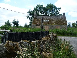
Peaston is a small settlement on the B6371 road in the parish of Ormiston in East Lothian, Scotland, about 14 miles (23 km) south-east of Edinburgh, 7 miles (11 km) south-west of Haddington, 4 miles (6.4 km) east of Ormiston and 2 miles (3.2 km) east of Pencaitland.

<span class="mw-page-title-main">Torthorwald</span>

Torthorwald is a village and civil parish in Dumfries and Galloway, south-west Scotland. It is located 6 kilometres (3.7 mi) east of Dumfries on the A709 road to Lochmaben. The area was the property of the de Torthorwald family until the end of the 13th century, when the estate passed by marriage to the Kirkpatricks. In 1418, William de Carleil married the Kirkpatrick heiress. He may have been the builder of Torthorwald Castle, which was erected around this time, possibly on top of an earlier a motte. Torthorwald was erected as a burgh of barony in 1473. Torthorwald Castle was occupied until 1715; only two of its walls still stand, to a height of around 18 metres (59 ft).

<span class="mw-page-title-main">Carriden House</span> Historic site in Boness, Falkirk, Scotland

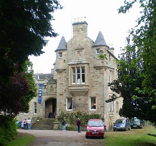
Carriden House is a 14,041 square feet (1,304.5 m2) mansion in the parish of Bo'ness and Carriden, in the Falkirk council area, east central Scotland. It is located on the Antonine Wall 2.5 kilometres (1.6 mi) east of Bo'ness, and 4 kilometres (2.5 mi) north-east of Linlithgow, in the former county of West Lothian. The earliest part of the house is an early 17th-century tower house, which was extended in the 17th and 19th centuries. Carriden House is protected as a category A listed building.

<span class="mw-page-title-main">Scotland's Rural College</span> Public land based research institution in Scotland, United Kingdom

Scotland's Rural College is a public land based research institution focused on agriculture and life sciences. Its history stretches back to 1899 with the establishment of the West of Scotland Agricultural College and its current organisation came into being through a merger of smaller institutions.

<span class="mw-page-title-main">Threemiletown</span> Human settlement in Scotland

Threemiletown is a village in West Lothian, Scotland. The settlement sits north of Ecclesmachan and west of Winchburgh.

References

  1. 1 2 3 4 5 6 7 Jaques and McKean (1 September 1994). West Lothian - An Illustrated Architectural Guide. Scotland: The Rutland Press. pp. 44–45. ISBN   978-1873190258.
  2. Bethany Fox, 'The P-Celtic Place-Names of North-East England and South-East Scotland', The Heroic Age, 10 (2007), http://www.heroicage.org/issues/10/fox.html (appendix at http://www.heroicage.org/issues/10/fox-appendix.html).
  3. 1 2 3 Historic Environment Scotland. "ECCLESMACHAN KIRK (ST. MACHAN'S) (Category B Listed Building) (LBnum)" . Retrieved 31 October 2021.
  4. Historic Environment Scotland. "Ecclesmachan Parish Church (49272)". Canmore . Retrieved 31 October 2021.
  5. 1 2 Buildings of Scotland: Lothian by Colin McWilliam
  6. Historic Environment Scotland. "Ecclesmachan Parish Church, Churchyard (214302)". Canmore . Retrieved 31 October 2021.
  7. Historic Environment Scotland. "SMIDDY COTTAGE (HENDERSONS) OPPOSITE KIRK (Category C Listed Building) (LB657)" . Retrieved 31 October 2021.
  8. 1 2 Historic Environment Scotland. "BINNY HOUSE (Category B Listed Building) (LB658)" . Retrieved 31 October 2021.
  9. Historic Environment Scotland. "BINNY DOOCOT AT BINNY HOUSE (Category B Listed Building) (LB659)" . Retrieved 31 October 2021.
  10. Historic Environment Scotland. "MIDDLE EAST LODGE, BINNY POLICIES (Category B Listed Building) (LBnum)" . Retrieved 31 October 2021.
  11. Historic Environment Scotland. "THOMSON OF BINNY MAUSOLEUM BINNY POLICIES (Category C Listed Building) (LB661)" . Retrieved 31 October 2021.
  12. Historic Environment Scotland. "Ecclesmachan, Oatridge Agricultural College (275088)". Canmore . Retrieved 31 October 2021.
  13. 1 2 "SRUC Oatridge West Lothian". SRUC. Retrieved 31 October 2021.
  14. "Education and Careers: SRUC offers skills for rural jobs". The Scottish Farmer. Retrieved 31 October 2021.
  15. "Home Page". SNEC. Retrieved 31 October 2021.
  16. "Ecclesmachan. Old Industry Information Page". www.ecclesmachan.org.uk. Retrieved 8 June 2021.
  17. Historic Environment Scotland. "Binny Quarry (192279)". Canmore . Retrieved 31 October 2021.