Egypt Lake-Leto, Florida

Last updated

Egypt Lake-Leto, Florida
EgyptLakeLetoFL.png
U.S. Census map of Egypt Lake-Leto CDP, Florida
Hillsborough County Florida Incorporated and Unincorporated areas Egypt Lake-Leto Highlighted.svg
Location in Hillsborough County and the state of Florida
Coordinates: 28°0′55″N82°30′26″W / 28.01528°N 82.50722°W / 28.01528; -82.50722
Country United States
State Florida
County Hillsborough
Area
[1]
  Total6.23 sq mi (16.14 km2)
  Land5.91 sq mi (15.30 km2)
  Water0.32 sq mi (0.84 km2)
Elevation
43 ft (13 m)
Population
 (2020)
  Total36,644
  Density6,202.44/sq mi (2,394.79/km2)
Time zone UTC-5 (Eastern (EST))
  Summer (DST) UTC-4 (EDT)
ZIP Code
33614
Area code(s) 813, 656
FIPS code 12-20108 [2]
GNIS feature ID1853249 [3]

Egypt Lake-Leto is a census-designated place (CDP) in an unincorporated part of Hillsborough County, Florida, United States. The CDP is located just north of Tampa International Airport. It is part of the Tampa Bay area. As of the 2020 US census, the population had 36,644 residents.

Contents

Geography

Egypt Lake-Leto is located in northwestern Hillsborough County at 28°0′55″N82°30′26″W / 28.01528°N 82.50722°W / 28.01528; -82.50722 (28.015396, -82.507311), [4] 7 miles (11 km) northwest of downtown Tampa. The elevation for the CDP is 45 feet (14 m) above sea level.

According to the United States Census Bureau, the CDP has a total area of 6.2 square miles (16.1 km2), of which 5.9 square miles (15.3 km2) are land and 0.3 square miles (0.8 km2), or 5.16%, are water. [5]

The Egypt Lake-Leto CDP contains the communities of Egypt Lake, Leto, and West Park Estates.

Demographics

Historical population
CensusPop.Note
1970 16,014
1980 20,03525.1%
1990 24,92724.4%
2000 32,78231.5%
2010 35,2827.6%
2020 36,6443.9%
source: [6] [7]
Egypt Lake-Leto racial composition
(Hispanics excluded from racial categories)
(NH = Non-Hispanic)
RacePop 2010 [8] Pop 2020 [9] % 2010% 2020
White (NH)9,4177,01426.69%19.14%
Black or African American (NH)2,9392,5698.33%7.01%
Native American or Alaska Native (NH)46370.13%0.10%
Asian (NH)1,2581,5413.57%4.21%
Pacific Islander or Native Hawaiian (NH)820.02%0.01%
Some other race (NH)661750.19%0.48%
Two or more races/Multiracial (NH)3917661.11%2.09%
Hispanic or Latino (any race)21,15724,54059.97%66.97%
Total35,28236,644

As of the 2020 United States census, there were 36,644 people, 13,603 households, and 8,533 families residing in the CDP. [10]

In 2020, by age the population was split with 5.6% under 5 years old, 16.5% under 18 years old, and 12.4% 65 years or older. 48.5% of the population were female persons.

As of 2020, there were 1,065 veterans living in the CDP and 44.8% of the population were foreign born persons. The average household had 2.57 persons.

In 2020, the owner-occupied housing rate was 45.0%. The median value of owner-occupied housing units was $212,400. The median monthly owner costs with a mortgage was $1,302 and without a mortgage was $427. The median gross rent was $1,126. 95.7% of households had a computer and 92.6% had a broadband Internet subscription. 80.3% of the population 25 years and older were high school graduates or higher and 21.4% of that same population had a Bachelor's degree or higher. The median household income was $48,240 and the per capita income was $25,425. 17.4% of the population lived below the poverty threshold.

As of the 2010 United States census, there were 35,282 people, 13,600 households, and 7,972 families residing in the CDP. [11]

Education

The area of Egypt Lake-Leto is served by Hillsborough County Schools.

Public elementary

Public middle

Public high

Healthcare

The only hospital that operates in Egypt Lake-Leto is AdventHealth Carrollwood. [12]

Related Research Articles

<span class="mw-page-title-main">Citrus Park, Florida</span> Census-designated place in Florida, United States

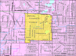
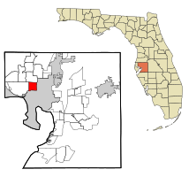
Citrus Park is an unincorporated census-designated place in Hillsborough County, Florida, United States. The population was 28,178 at the 2020 census, up from 24,252 at the 2010 census.

<span class="mw-page-title-main">Northdale, Florida</span> Census-designated place in Florida, United States

Northdale is an unincorporated census-designated place in Hillsborough County, Florida, United States. Northdale was named by the combination of the words in North Dale Mabry, the main highway through the Northdale area. The population was 22,079 at the 2010 census.

<span class="mw-page-title-main">Keystone, Florida</span> Census-designated place in Florida, United States

Keystone is an unincorporated census-designated place in Hillsborough County, Florida, United States. The Keystone area was first settled in the middle 1800s by the W.M. Mobley Family who migrated from Savannah, Georgia. The region has evolved from citrus and farming into a rural retreat of many lake homes and ranches. The population was 24,039 at the 2010 census, up from 14,627 at the 2000 census. The ZIP Codes encompassing the CDP area are 33556 and 33558.

<span class="mw-page-title-main">Lake Magdalene, Florida</span> Census-designated place in Florida, United States

Lake Magdalene is a census-designated place (CDP) in Hillsborough County, Florida, United States. It is part of the Tampa Bay area. The population was 30,742 at the 2020 census.

<span class="mw-page-title-main">Lutz, Florida</span> Unincorporated Community in Florida, United States

Lutz is an unincorporated community in Hillsborough County and Pasco County, Florida, United States, 15 miles (24 km) north of Tampa. While there is a census-designated area of Lutz, the community itself extends beyond those boundaries into other census-designated areas.

<span class="mw-page-title-main">Riverview, Florida</span> Census-designated place in Florida, United States

Riverview is an unincorporated census-designated place in Hillsborough County, Florida, United States. It is located south of Brandon. The population was 107,396 in the 2020 census, up from 71,050 in the 2010 census.

<span class="mw-page-title-main">Town 'n' Country, Florida</span> Census-designated place in Florida, United States

Town 'n' Country is a census-designated place (CDP) in Hillsborough County, Florida, United States. The population was 85,951 at the 2020 census.

<span class="mw-page-title-main">University, Hillsborough County, Florida</span> Census-designated place in Florida, United States

University is an unincorporated census-designated place in Hillsborough County, Florida, United States. The population was 41,163 at the 2010 census, up from 30,736 at the 2000 census. The University of South Florida is located just southeast of the community, within the Tampa city limits. The community is also known as "University West", mainly due to its location in relation to the university. The community is often notoriously referred to by locals as "Suitcase City" due to the high rate of transients.

<span class="mw-page-title-main">Valrico, Florida</span> Census-designated place in Florida, United States

Valrico is a census-designated place (CDP) in Hillsborough County, Florida, United States. As of 2020 the population was 37,895.

<span class="mw-page-title-main">Tamiami, Florida</span> Census-designated place in Florida

Tamiami is a census-designated place (CDP) in Miami-Dade County, Florida, United States. It is part of the Miami metropolitan area of South Florida. The population was 54,212 at the 2020 census.

<span class="mw-page-title-main">The Crossings, Florida</span> CDP in Florida

The Crossings is a census-designated place (CDP) and suburb of Miami in Miami-Dade County, Florida, United States. It is part of the Miami metropolitan area of South Florida. The CDP includes the neighborhoods of The Crossings, Devon Aire, and Calusa. The population was 23,276 at the 2020 census.

<span class="mw-page-title-main">The Hammocks, Florida</span> Census-designated place in Florida

The Hammocks is a planned community and census-designated place in Miami-Dade County, Florida, United States. It is part of the Miami metropolitan area of South Florida. The population was 59,480 at the 2020 census, up from 51,003 in 2010.

<span class="mw-page-title-main">Land o' Lakes, Florida</span> Census-designated place in Florida, United States

Land O' Lakes is a census-designated place (CDP) in Pasco County, Florida, United States. It is part of the Tampa-St. Petersburg-Clearwater, Florida MSA. As of the 2020 US census, the CDP had a population of 35,929.

<span class="mw-page-title-main">East Lake, Pinellas County, Florida</span> Census-designated place in Florida, United States

East Lake is a census-designated place (CDP) in Pinellas County, Florida, United States. It was one of the last areas in the densely populated county to develop and often confused with East Lake in neighboring Hillsborough County. The population was 32,344 at the 2020 census.

<span class="mw-page-title-main">Carrollwood (CDP), Florida</span> Census-designated place in Florida, United States

Carrollwood is a census-designated place (CDP) in northwestern Hillsborough County, Florida, United States. The census area includes the unincorporated communities of Carrollwood and Carrollwood Village. For the 2000 census the area was enumerated under the name "Greater Carrollwood". A similar area was listed as "Lake Carroll" in 1970 and 1980; for the 1990 census it was split into the smaller Carrollwood and Carrollwood Village CDPs. The population was 34,352 at the 2020 census.

<span class="mw-page-title-main">Sun City Center, Florida</span> Census-designated place in Florida, United States

Sun City Center is an unincorporated census-designated place (CDP) in southern Hillsborough County, Florida, United States. It is located south of Tampa and north of Sarasota on I-75. As of the 2020 census, the population was 30,952. The ZIP Code serving the community is 33573.

<span class="mw-page-title-main">Carrollwood, Florida</span> Unincorporated community in Florida, United States

Carrollwood is an unincorporated community in Hillsborough County, Florida, United States. It is part of the larger census-designated place (CDP) of Carrollwood, which also includes the neighborhood of Carrollwood Village. A census-designated place corresponding just to Carrollwood existed during the 1990 census, with a population of 7,195. The ZIP code for Carrollwood is 33618.

Egypt Lake is an unincorporated community in northwestern Hillsborough County, Florida, United States. It is located within the census-designated place of Egypt Lake-Leto. It was a separate census-designated place from 1970 to 1990. The population as of the 1990 census was 14,580. The ZIP code for Egypt Lake is 33614.

Leto is an unincorporated community in northwestern Hillsborough County, Florida, United States. Along with Egypt Lake, it is a part of the census-designated place (CDP) of Egypt Lake-Leto. It was a separate CDP from 1970 to 1990, and was known as West Park in 1990. The population as of the 1990 census was 10,347.

<span class="mw-page-title-main">Alafaya, Florida</span> Census-designated place in Florida, United States

Alafaya is a census-designated place and unincorporated area in Orange County, Florida, United States. The population was 92,452 at the 2020 US census. It is part of the Orlando–Kissimmee–Sanford, Florida Metropolitan Statistical Area. It is most known for being near the University of Central Florida, Avalon Park and Waterford Lakes.

References

  1. "2020 U.S. Gazetteer Files". United States Census Bureau. Retrieved October 31, 2021.
  2. "U.S. Census website". United States Census Bureau . Retrieved January 31, 2008.
  3. "US Board on Geographic Names". United States Geological Survey. October 25, 2007. Retrieved January 31, 2008.
  4. "US Gazetteer files: 2010, 2000, and 1990". United States Census Bureau. February 12, 2011. Retrieved April 23, 2011.
  5. "Geographic Identifiers: 2010 Demographic Profile Data (G001): Egypt Lake-Leto CDP, Florida". American Factfinder. U.S. Census Bureau. Retrieved May 3, 2017.[ dead link ]
  6. "Census of Population and Housing". U.S. Census Bureau . Retrieved January 29, 2014.
  7. Note: This includes the combined U.S. census totals from 1970-1990, during which both Egypt Lake and Leto were considered separate CDPs.
  8. "P2 HISPANIC OR LATINO, AND NOT HISPANIC OR LATINO BY RACE - 2010: DEC Redistricting Data (PL 94-171) - Egypt Lake-Leto CDP, Florida". United States Census Bureau .
  9. "P2 HISPANIC OR LATINO, AND NOT HISPANIC OR LATINO BY RACE - 2020: DEC Redistricting Data (PL 94-171) - Egypt Lake-Leto CDP, Florida". United States Census Bureau .
  10. "S1101 HOUSEHOLDS AND FAMILIES - 2020: Egypt Lake-Leto CDP, Florida". United States Census Bureau .
  11. "S1101 HOUSEHOLDS AND FAMILIES - 2010: Egypt Lake-Leto CDP, Florida". United States Census Bureau .
  12. Kritzer, Ashley (February 14, 2023). "AdventHealth Carrollwood makes $20.7 million property purchase". Tampa Bay Business Journal . Retrieved April 5, 2024.