Eibenstock

Last updated
Eibenstock
Eibenstock.JPG
Wappen Eibenstock.png
Location of Eibenstock within Erzgebirgskreis district
Eibenstock in ERZ.pngAuerbachBreitenbrunnNeukirchenNiederdorfOelsnitzSchneebergSchwarzenbergTannenbergThalheim
Germany adm location map.svg
Red pog.svg
Eibenstock
Saxony location map.svg
Red pog.svg
Eibenstock
Coordinates: 50°29′44″N12°35′51″E / 50.49556°N 12.59750°E / 50.49556; 12.59750
Country Germany
State Saxony
District Erzgebirgskreis
Subdivisions13
Government
   Mayor (202229) Uwe Staab [1] (CDU)
Area
  Total112.35 km2 (43.38 sq mi)
Elevation
650 m (2,130 ft)
Population
 (2021-12-31) [2]
  Total7,075
  Density63/km2 (160/sq mi)
Time zone UTC+01:00 (CET)
  Summer (DST) UTC+02:00 (CEST)
Postal codes
08309
Dialling codes 037752
Vehicle registration ERZ, ANA, ASZ, AU, MAB, MEK, STL, SZB, ZP
Website www.eibenstock.de

Eibenstock is a town in the Erzgebirgskreis, Saxony, Germany. It is situated in the western Ore Mountains, near the river Mulde.

Contents

Geography

Eibenstock has the following constituent communities: Eibenstock, Blauenthal, Wolfsgrün, Neidhardtsthal, Wildenthal, Oberwildenthal, Carlsfeld, Blechhammer, Neues Wiesenhaus, Sosa, Stabhammer, Wilzschmühle and Weitersglashütte.

Wildenthal Wildenthal, Germany.jpg
Wildenthal

History

Middle Ages

Owing to its elevation of more than 600 m, Eibenstock would not have been one of the first farming villages in the Ore Mountains, but rather a longstanding settlement in the form of a radial forest homestead village, founded at the earliest sometime in the thirteenth century in what later became the Barony of Schwarzenberg. About 1.5 km from the edge of town, not far from where the Steinbächel empties into the Große Bockau, a ringwall was unearthed.

The first two documentary mentions as Ybenstok and Ibenstok both date from the year 1378. At that time, an Alte Seife (“Old Placer”) was named, hinting that the village's development was also spurred by mining. Placer mines were being worked in the Eibenstock area even as late as the 19th century, although at the same time, iron ore and tin were also being mined from harder deposits. In 1560 Eibenstock became the official seat of a Bergamt ("mining office") and thereafter called itself freie Bergstadt ("free mining town").

In 1453, Elector Friedrich of Saxony fiefed the Brothers Leonhart und Nickel von Tannenberg auf Plohn with, among other things, the villages of Eibenstock, Sosa and Burkhardtsgrün. These were not under the new ownership for very long, as Wilhelm von Tannenberg had to give up Eibenstock by 1456 to the Hereditary Marshal of Saxony, Hans Löser. In 1464, Eibenstock passed to the lordly estate of Schwarzenberg and hence to the Saxon Amt of Schwarzenberg in 1533.

In 1532, the community was described as a market town, and in 1555 as a small town. The town was only granted market rights in 1639. In 1734, for the first time, a fish market was held at which fresh fish brought in from Hamburg was sold.

19th Century to Present

Clara Angermann brought Tambourieren to the town in 1775, a kind of artistic lace embroidery. [3] She taught this to the women until 1780, and thereafter embroidery began to blossom. By 1850 there were 6 successful embroidering businesses and in 1858, the first embroidery machine went into operation. The work was famous worldwide, so much so that from 1891 to 1908, the United States even maintained a consulate in town to foster their business relationships.

After three great fires (1856, 1862 and 1892), to which whole neighbourhoods fell victim, reconstruction was undertaken in such a way as to give the buildings a more contemporary look. Between 1864 and 1868, the neo-Romanesque church was built, and in 1906 and 1907 a new art nouveau town hall.

With the First World War (1914–1918), the embroidery industry collapsed and could only establish itself once again after the Second World War. However, it never again achieved the level of fame that it had enjoyed before 1914.

From 1952 to 1990, Eibenstock was part of the Bezirk Karl-Marx-Stadt of East Germany. Small embroidery businesses merged into collectives such as the Produktionsgenossenschaften des Handwerks (PGH) Sticktex or the Eibenstocker Buntstickerei, but then in 1972, these were converted into a Volkseigener Betrieb (“nationally owned business”, a kind of enterprise found in the former East Germany)

Eibenstock Reservoir Eibenstock reservoir (aka).jpg
Eibenstock Reservoir

Between 1974 and 1979 the second biggest dam project in East Germany was realized. A basin with 77 million cubic metres of storage and 350 ha in area was created and now supplies roughly a million people with drinking water.

After the political and economic changes of 1989 and 1990, Eibenstock's economy suffered, like that of much of the former East Germany, which had its ramifications for the administration of small communities. It became impossible to run them independently, and for this reason came on 1 January 1994 the amalgamation of Blauenthal, Neidhardtsthal, Wolfsgrün, Wildenthal and Oberwildenthal with Eibenstock, and likewise on 1 April 1997 of Carlsfeld and Weitersglashütte.

In 2005 Eibenstock celebrated 850 years of existence.

Climate

Climate data for Carlsfeld, Eibenstock (elevation 895 m (2,936 ft) (1991−2020 normals)
MonthJanFebMarAprMayJunJulAugSepOctNovDecYear
Average high °C (°F)−0.4
(31.3)
0.6
(33.1)
4.0
(39.2)
9.4
(48.9)
13.8
(56.8)
17.2
(63.0)
19.1
(66.4)
19.0
(66.2)
14.4
(57.9)
9.3
(48.7)
4.0
(39.2)
0.5
(32.9)
9.2
(48.6)
Daily mean °C (°F)−2.8
(27.0)
−2.4
(27.7)
0.5
(32.9)
5.2
(41.4)
9.4
(48.9)
12.7
(54.9)
14.6
(58.3)
14.5
(58.1)
10.4
(50.7)
6.0
(42.8)
1.4
(34.5)
−1.8
(28.8)
5.6
(42.1)
Average low °C (°F)−5.1
(22.8)
−4.9
(23.2)
−2.5
(27.5)
1.0
(33.8)
4.9
(40.8)
8.0
(46.4)
10.1
(50.2)
10.0
(50.0)
6.5
(43.7)
3.2
(37.8)
−0.8
(30.6)
−4.0
(24.8)
2.2
(36.0)
Average precipitation mm (inches)95.1
(3.74)
75.5
(2.97)
96.0
(3.78)
65.7
(2.59)
95.9
(3.78)
111.8
(4.40)
126.4
(4.98)
109.6
(4.31)
102.1
(4.02)
93.9
(3.70)
90.5
(3.56)
102.5
(4.04)
1,170.9
(46.10)
Average precipitation days (≥ 0.1 mm)18.917.118.015.216.916.517.115.215.216.417.220.2204.1
Average relative humidity (%)89.887.384.176.977.078.176.977.683.588.691.591.183.2
Mean monthly sunshine hours 56.273.3111.2166.3191.3190.7201.7197.5151.1105.258.449.31,553.3
Source: NOAA [4]

Population development

Source as of 1998: Statistisches Landesamt des Freistaates Sachsen

Local council

The elections in May 2014 showed the following results:

Culture and sightseeing

Neo-Romanesque church Eibenstock Church (aka).jpg
Neo-Romanesque church
Electorate of Saxony postal milestone at the Postplatz DS-Eibenstock.jpg
Electorate of Saxony postal milestone at the Postplatz

Economy and infrastructure

From the 14th to 18th centuries there was tin and iron ore mining in the region. After a great famine in 1771-1773, this industry was largely displaced by the embroidery industry.

Notable people

Honorary citizens

Related Research Articles

<span class="mw-page-title-main">Zschopau</span> Town in Saxony, Germany

Zschopau, is a town in the Erzgebirgskreis district of Saxony, Germany.

<span class="mw-page-title-main">Bad Gottleuba-Berggießhübel</span> Spa town in Saxony, Germany

Bad Gottleuba-Berggießhübel is a spa town in the district Sächsische Schweiz-Osterzgebirge in Saxony, Germany. The municipality borders the Czech Republic in the south. The municipality was formed on 1 January 1999 by the merger of the former municipalities Bad Gottleuba, Berggießhübel, Langenhennersdorf, and Bahratal. Surrounded by forests and near a water dam, Bad Gottleuba-Berggießhübel has several facilities including a spa health park, a plant garden, and a heated open air pool.

<span class="mw-page-title-main">Schneeberg, Saxony</span> Town in Saxony, Germany

Schneeberg is a town in Saxony’s district of Erzgebirgskreis. It has roughly 16,400 inhabitants and belongs to the Town League of Silberberg. It lies 4 km west of Aue, and 17 kilometres (11 mi) southeast of Zwickau.

<span class="mw-page-title-main">Lößnitz</span> Town in Saxony, Germany

Bergstadt Lößnitz, sometimes also called Muhme (“Aunt”) for its age, is a town in the district of Erzgebirgskreis, Saxony, Germany, and belongs to the Town League of Silberberg. Its name comes from the Slavic lesnice, meaning “forest place”.

<span class="mw-page-title-main">Brand-Erbisdorf</span> Town in Saxony, Germany

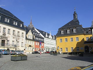
Brand-Erbisdorf is a small town in the district of Mittelsachsen, in Saxony, Germany. It is situated 5 km south of Freiberg. As of 2020, the town has a population of 9,145.

<span class="mw-page-title-main">Grünhain-Beierfeld</span> Town in Saxony, Germany

Grünhain-Beierfeld is a town in the district of Erzgebirgskreis in Saxony, Germany lying 8 km east of Aue. It came into being on 1 January 2005 through the merger of the town of Grünhain and the community of Beierfeld.

<span class="mw-page-title-main">Johanngeorgenstadt</span> Town in Saxony, Germany

Johanngeorgenstadt is a mining town in Saxony’s Ore Mountains, 17 km south of Aue, and 27 km northwest of Karlovy Vary. It lies in the district of Erzgebirgskreis, on the border with the Czech Republic, is a state-recognized health resort (Erholungsort), and calls itself Stadt des Schwibbogens. Its population decline since the 1950s has been extremely severe, falling from 45,000 residents in 1953 to only about one twelfth of that now.

Lauter is a town in the district of Erzgebirgskreis in Saxony, Germany. It lies between the two towns of Aue and Schwarzenberg. It lies in the Ore Mountains, 4 km southeast of Aue, and 4 km northwest of Schwarzenberg, has about 4,700 inhabitants in an area of 21.55 km² and belongs to the Town League of Silberberg. Since 1 January 2013, it is part of the town Lauter-Bernsbach.

<span class="mw-page-title-main">Scheibenberg</span> Town in Saxony, Germany

Scheibenberg is a town in the district of Erzgebirgskreis in Saxony in Germany. It is situated in the Ore Mountains, 8 km southwest of Annaberg-Buchholz, and 9 km east of Schwarzenberg.

<span class="mw-page-title-main">Schlettau</span> Town in Saxony, Germany

Schlettau is a town in the district of Erzgebirgskreis, in Saxony in Germany. It is situated in the Ore Mountains, 5 km southwest of Annaberg-Buchholz, and 12 km east of Schwarzenberg.

<span class="mw-page-title-main">Geyer</span> Town in Saxony, Germany

Geyer is a town in the district of Erzgebirgskreis, in Saxony, Germany. It has a population of about 4,000.

<span class="mw-page-title-main">Seiffen</span> Municipality in Saxony, Germany

The town of Seiffen is located in the district of Erzgebirgskreis, which is in the central south of the Free State of Saxony in Germany. The earliest record of the town dates to 1324 when it was referred to as "Cynsifen".

<span class="mw-page-title-main">Bockau</span> Municipality in Saxony, Germany

Bockau is a municipality in the district of Erzgebirgskreis in the Free State of Saxony in Germany. The community is known for growing and researching herbs. Owing to its centuries-old cultivation of angelica, whose roots are used in making liqueurs, Bockau is also known locally by the nickname Wurzelbucke.

<span class="mw-page-title-main">Breitenbrunn, Saxony</span> Municipality in Saxony, Germany

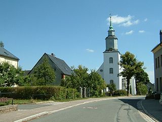
Breitenbrunn is a community in the Ore Mountains in the district of Erzgebirgskreis in the Free State of Saxony in Germany.

Pöhla is a village and a former municipality lying in the valley of the river Pöhlwasser, in the district of Aue-Schwarzenberg in Saxony, Germany. Since 1 January 2008, it is part of the town Schwarzenberg.

<span class="mw-page-title-main">Schönheide</span> Municipality in Saxony, Germany

Schönheide is a municipality in Saxony's district of Erzgebirgskreis. It lies in the western Ore Mountains, and was founded as an industrial village.

<span class="mw-page-title-main">Sosa, Germany</span> Ortsteil of Eibenstock in Saxony, Germany

Sosa is a former municipality in the western Ore Mountains, in the Erzgebirgskreis, Saxony, Germany. It is a state-recognized health resort, that has belonged to the town Eibenstock since 1 January 2011.

<span class="mw-page-title-main">Stützengrün</span> Municipality in Saxony, Germany

Stützengrün is a community in the district of Erzgebirgskreis, Saxony, Germany.

<span class="mw-page-title-main">Wildenthal (Eibenstock)</span> Ortsteil of Eibenstock in Saxony, Germany

Wildenthal is a village in the town of Eibenstock in the district of Erzgebirgskreis in the Saxon Ore Mountains of Central Germany.

<span class="mw-page-title-main">Hundshübel</span> Village of Stützengrün in Saxony, Germany

Hundshübel is a village in Erzgebirgskreis district of Saxony, forming a subdivision of the municipality of Stützengrün in the Ore Mountains. It is located north of Eibenstock Dam on federal highway B 169.

References

  1. Gewählte Bürgermeisterinnen und Bürgermeister im Freistaat Sachsen, Stand: 17. Juli 2022, Statistisches Landesamt des Freistaates Sachsen.
  2. "Bevölkerung des Freistaates Sachsen nach Gemeinden am 31. Dezember 2021" (XLS) (in German). Statistisches Landesamt des Freistaates Sachsen. 2022.
  3. Chisholm, Hugh, ed. (1911). "Eibenstock"  . Encyclopædia Britannica . Vol. 9 (11th ed.). Cambridge University Press. p. 131.
  4. "Carlsfeld Climate Normals 1991–2020". National Oceanic and Atmospheric Administration. Archived from the original on 16 September 2023. Retrieved 16 September 2023.