Elmore, Minnesota

Last updated

Elmore
Faribault County Minnesota Incorporated and Unincorporated areas Elmore Highlighted.svg
Location of Elmore, Minnesota
Coordinates: 43°30′23″N94°05′18″W / 43.50639°N 94.08833°W / 43.50639; -94.08833
Country United States
State Minnesota
County Faribault
Government
  TypeMayor - Council
  MayorBjorn Olson [ citation needed ]
Area
[1]
  Total0.85 sq mi (2.19 km2)
  Land0.85 sq mi (2.19 km2)
  Water0.00 sq mi (0.00 km2)
Elevation
[2]
1,125 ft (343 m)
Population
 (2020)
  Total549
  Density648.94/sq mi (250.50/km2)
Time zone UTC-6 (Central (CST))
  Summer (DST) UTC-5 (CDT)
ZIP code
56027
Area code 507
FIPS code 27-18998 [3]
GNIS feature ID2394675 [2]

Elmore is a city in Faribault County, Minnesota, United States. The population was 663 at the 2010 census. [4] Elmore was the boyhood home of former U.S. Vice President and Democratic presidential candidate Walter F. Mondale. [5]

Contents

History

A post office called Elmore has been in operation since 1863. [6] The city was named for Andrew E. Elmore, an early settler. [7]

Geography

According to the United States Census Bureau, the city has a total area of 0.92 square miles (2.38 km2), all land. [8] Elmore borders the state of Iowa to its south.

U.S. Highway 169 serves as a main route in the community.

Demographics

Historical population
CensusPop.Note
1890 488
1900 92489.3%
1910 795−14.0%
1920 90413.7%
1930 744−17.7%
1940 93525.7%
1950 1,07414.9%
1960 1,0780.4%
1970 910−15.6%
1980 882−3.1%
1990 709−19.6%
2000 7353.7%
2010 663−9.8%
2020 549−17.2%
U.S. Decennial Census [9]

2010 census

As of the census [10] of 2010, there were 663 people, 266 households, and 158 families living in the city. The population density was 720.7 inhabitants per square mile (278.3/km2). There were 320 housing units at an average density of 347.8 per square mile (134.3/km2). The racial makeup of the city was 92.2% White, 2.7% African American, 1.7% Native American, 0.2% Asian, 1.7% from other races, and 1.7% from two or more races. Hispanic or Latino of any race were 13.1% of the population.

There were 266 households, of which 24.8% had children under the age of 18 living with them, 41.7% were married couples living together, 12.0% had a female householder with no husband present, 5.6% had a male householder with no wife present, and 40.6% were non-families. 36.1% of all households were made up of individuals, and 15.1% had someone living alone who was 65 years of age or older. The average household size was 2.23 and the average family size was 2.82.

The median age in the city was 38.6 years. 29.3% of residents were under the age of 18; 7.4% were between the ages of 18 and 24; 18.1% were from 25 to 44; 26.7% were from 45 to 64; and 18.4% were 65 years of age or older. The gender makeup of the city was 49.5% male and 50.5% female.

2000 census

As of the census [3] of 2000, there were 735 people, 305 households, and 185 families living in the city. The population density was 815.9 inhabitants per square mile (315.0/km2). There were 338 housing units at an average density of 375.2 per square mile (144.9/km2). The racial makeup of the city was 92.11% White, 1.77% African American, 1.22% Native American, 1.22% Asian, 2.31% from other races, and 1.36% from two or more races. Hispanic or Latino of any race formed 4.76% of the population.

There were 305 households, of which 21.6% had children under the age of 18 living with them, 48.5% were married couples living together, 8.2% had a female householder with no husband present, and 39.3% were non-families. 36.1% of all households were made up of individuals, and 19.7% had someone living alone who was 65 years of age or older. The average household size was 2.13 and the average family size was 2.73.

In the city, the population was spread out, with 28.7% under the age of 18, 7.6% from 18 to 24, 18.2% from 25 to 44, 23.1% from 45 to 64, and 22.3% who were 65 years of age or older. The median age was 42 years. For every 100 females, there were 109.4 males. For every 100 females age 18 and over, there were 88.5 males.

The median income for a household in the city was $26,146, and the median income for a family was $34,583. Males had a median income of $23,906 versus $19,375 for females. The per capita income for the city was $15,761. About 8.1% of families and 11.8% of the population were below the poverty line, including 15.0% of those under age 18 and 14.7% of those age 65 or over.

Related Research Articles

<span class="mw-page-title-main">Elmore County, Alabama</span> County in Alabama, United States

Elmore County is a county located in the east central portion of the U.S. state of Alabama. As of the 2020 census, the population was 87,977. Its county seat is Wetumpka. Its name is in honor of General John A. Elmore.

<span class="mw-page-title-main">Tallapoosa County, Alabama</span> County in Alabama, United States

Tallapoosa County is located in the east-central portion of the U.S. state of Alabama. As of the 2020 census, the population was 41,311. Its county seat is Dadeville. Its largest city is Alexander City.

<span class="mw-page-title-main">Good Hope, Alabama</span> City in Alabama, United States

Good Hope is a city in Cullman County, Alabama, United States. As of the 2010 census, the population of the city was 2,264. It incorporated in April 1962.

<span class="mw-page-title-main">Blue Ridge, Alabama</span> Census-designated place in Alabama, United States

Blue Ridge is an unincorporated community and census-designated place (CDP) in Elmore County, Alabama, United States. At the 2020 census, the population was 1,485. It is part of the Montgomery Metropolitan Statistical Area.

<span class="mw-page-title-main">Coosada, Alabama</span> Town in Elmore County, Alabama, United States

Coosada is a town in Elmore County, Alabama, United States. At the 2020 census, the population was 1,217. It is part of the Montgomery Metropolitan Statistical Area.

<span class="mw-page-title-main">Deatsville, Alabama</span> Town in Alabama, United States

Deatsville is a town in Elmore County, Alabama, United States. Although Deatsville initially incorporated in 1903, it lapsed at some point after the 1910 U.S. Census and did not appear again as incorporated until 2000. As of the 2020 census, the population was 1,679.

<span class="mw-page-title-main">Eclectic, Alabama</span> Village in Alabama, United States

Eclectic is a town in Elmore County, Alabama, United States. It incorporated in 1907. At the 2020 census, the population was 1,193. It is part of the Montgomery Metropolitan Statistical Area.

<span class="mw-page-title-main">Elmore, Alabama</span> Town in Alabama, United States

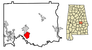
Elmore is a town in Elmore County, Alabama, United States. Although initially incorporated in 1906, it lapsed and was not reincorporated again until 1997. At the 2010 census the population was 1,262, up from 199 in 2000. It is part of the Montgomery Metropolitan Statistical Area.

<span class="mw-page-title-main">Grand View, Idaho</span> City in Owyhee County, Idaho, United States

Grand View is a city along the Snake River in Owyhee County, Idaho, United States. The population was 452 at the 2010 census. It is part of the Boise City–Nampa, Idaho Metropolitan Statistical Area.

Danville Township is a township in Blue Earth County, Minnesota, United States. The population was 262 as of the 2000 census.

<span class="mw-page-title-main">Delavan, Minnesota</span> City in Minnesota, United States

Delavan is a city in Faribault County, Minnesota, United States. The population was 179 at the 2010 census.

<span class="mw-page-title-main">Easton, Minnesota</span> City in Minnesota, United States

Easton is a city in Faribault County, Minnesota, United States. The population was 199 at the 2010 census.

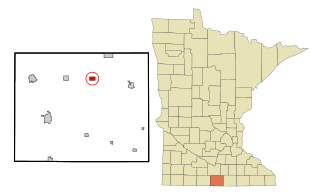
Elmore Township is a township in Faribault County, Minnesota, United States. The population was 203 at the 2000 census.

<span class="mw-page-title-main">Frost, Minnesota</span> City in Minnesota, United States

Frost is a city in Faribault County, Minnesota, United States. The population was 215 at the 2020 census.

Verona Township is a township in Faribault County, Minnesota, United States. The population was 391 at the 2000 census.

<span class="mw-page-title-main">Winnebago, Minnesota</span> City in Minnesota, United States

Winnebago is a city in Faribault County, Minnesota, United States. The population was 1,391 at the 2020 census.

<span class="mw-page-title-main">Deer Creek, Minnesota</span> City in Minnesota, United States

Deer Creek is a city in Otter Tail County, Minnesota, United States. The population was 330 at the 2020 census.

<span class="mw-page-title-main">St. John, Missouri</span> City in Missouri, United States

St. John or Saint John is a city in St. Louis County, Missouri, United States, with its commercial district centered along St. Charles Rock Road. It is a few miles southeast of Lambert-St. Louis International Airport.

<span class="mw-page-title-main">Elmore, Vermont</span> Town in Vermont, United States

Elmore is a town in Lamoille County, Vermont, United States. It was granted by the Vermont Republic in 1780, and was named for Colonel Samuel Elmore (1720–1805), one of the original grantees. The population was 886 at the 2020 census. Elmore contains the villages of East Elmore and Lake Elmore, as well as Elmore State Park, a 700-acre (2.8 km2) recreational area on the 219-acre (0.9 km2) Lake Elmore and on Elmore Mountain to the west.

<span class="mw-page-title-main">Minnesota Lake, Minnesota</span> City in Minnesota, United States

Minnesota Lake is a city in Blue Earth and Faribault counties in the State of Minnesota. The population was 661 at the 2020 census. The bulk of the city is in Faribault County; a small part extends into Blue Earth County.

References

  1. "2020 U.S. Gazetteer Files". United States Census Bureau. Retrieved July 24, 2022.
  2. 1 2 U.S. Geological Survey Geographic Names Information System: Elmore, Minnesota
  3. 1 2 "U.S. Census website". United States Census Bureau . Retrieved January 31, 2008.
  4. "2010 Census Redistricting Data (Public Law 94-171) Summary File". American FactFinder. United States Census Bureau . Retrieved April 27, 2011.[ dead link ]
  5. "Walter F. Mondale, 42nd Vice President (1977-1981)". U.S. Senate. Retrieved January 22, 2009.
  6. "Faribault County". Jim Forte Postal History. Archived from the original on April 2, 2015. Retrieved March 17, 2015.
  7. Chicago and North Western Railway Company (1908). A History of the Origin of the Place Names Connected with the Chicago & North Western and Chicago, St. Paul, Minneapolis & Omaha Railways. p. 68.
  8. "US Gazetteer files 2010". United States Census Bureau. Archived from the original on January 25, 2012. Retrieved November 13, 2012.
  9. "Census of Population and Housing". Census.gov. Retrieved June 4, 2015.
  10. "U.S. Census website". United States Census Bureau . Retrieved November 13, 2012.