Elmsted

Last updated

Elmsted
St James the Great, Elmsted - geograph.org.uk - 190938.jpg
St James has an unusual belfry on the tower
Kent UK location map.svg
Red pog.svg
Elmsted
Location within Kent
Population292 (parish, 2001 Census)
OS grid reference TR115449
District
Shire county
Region
Country England
Sovereign state United Kingdom
Post town Ashford
Postcode district TN25
Post townCanterbury
Postcode district CT4
Dialling code 01233
Police Kent
Fire Kent
Ambulance South East Coast
UK Parliament
List of places
UK
England
Kent
51°09′51″N1°01′35″E / 51.1643°N 1.0265°E / 51.1643; 1.0265 Coordinates: 51°09′51″N1°01′35″E / 51.1643°N 1.0265°E / 51.1643; 1.0265

Elmsted is a village and civil parish [1] in the Folkestone and Hythe District of Kent, England. It is located west of Stone Street (the B2068), [2] the Roman road which today takes traffic between Canterbury and Lympne. Within the parish are the settlements of Bodsham, North Leigh and Evington. [3] There are six elected members of the Parish Council. [4]

Contents

The parish's name, Elmsted, is formed of two words. Elm refers to the large number of Elm trees that grew there in Saxon times. The second part, sted, comes from the Saxon word stede meaning 'place'. [5]

Geography

Elmsted is a small parish encompassing an area of approximately 10 km square with its population scattered in small hamlets like Bodsham, North Leigh and Elmsted Court. Settlements are largely at the top of the chalky down land with surrounding, lowland areas being used for grazing Cattle and Sheep and other farming . [3] In these lower areas the ground contains far more in the way of clay and flint deposits than chalk. The Parish church of St James the Great lies in the center of the parish at a kilometer or two from the parish boundary in every direction. On its eastern boundary the parish largely follows parallel to the Roman Road Stone Street. However it dips into the hamlets of Stelling Minnis and into Sixmile cottages. The parish itself is 11 kilometers east of Ashford which is the nearest town.

The settlements in the parish are very scattered which can largely be attributed to the agricultural nature of the parish. Homesteads would be built next to the land that the people living in them farmed. [6] The laborers on the farms would then walk to their parish church. The parish boundaries have remained broadly consistent with only slight variations in the south-east of the parish. [7]

The parish contains no shops or doctors surgery but does have a primary school, a pub, a cidery and a number of bed-and-breakfasts. [8] The local school is Bodsham Church of England Primary School. [9] The School has around 90 students [10] and has a close link to the local church with a daily worship. It is part of the Federation of Church of England Primary Schools.

History

The Roman road Stone Street defines part of the parish's eastern border. Constructed after the 43 AD invasion of the British Isles, the road was made to make travel from Canterbury to the south coast faster and more direct for movements of troops in the Empire. It also made trade for areas surrounding the road easier [11] and later allowed the Archbishop of Canterbury to more easily monitor his diocese.

Elmsted was not named in the Domesday book but Bodsham, one of the hamlets in the parish was noted. This Is where the local school is situated today. [12]

One of the more prominent families in the parish's history were the Honywoods who lived at Evington from the 1400s until the 1900s. Signs of this can be seen in St James the Great Church where the south chapel is known as the Honywood Chapel. [3]

John Marius Wilson, of the Imperial Gazetteer of England and Wales gave the following description of the parish between 1870 and 1872

"ELMSTEAD, a parish in Elham district, Kent; 4½ miles ESE of Wye r. station, and 6½ ENE of Ashford. It has a post office under Ashford, and a fair on 25 July. Acres, 2, 692. Real property, £2, 692. Pop., 492. Houses, 93. The property is divided among a few. The living is a vicarage in the diocese of Canterbury. Value, £80. Patron, the Archbishop of Canterbury. The church is old but good." [13]

Today the church is still under the Archbishop of Canterbury [2] and whilst the church is now older it remains in good condition. The fair on the 25th of July for St James day now no longer takes place, though a spring fair occurs May 1 in Evington Hall. [12] The number of houses in Elmsted has increased significantly in the last 110 years. As of the 2011 census there were 140 houses, [14] an increase of 59 since 1901. [15]

St James the Great

The Honywood Chapel St James, Elmsted, Kent - South aisle - geograph.org.uk - 1737009.jpg
The Honywood Chapel

The Anglican church is dedicated to St James the Great and dates back to the 11th century. It was restored in 1877 by Ewan Christian. [16] It was Grade I listed in 1966 due to its historic and architectural significance. [17] The church has an unusual wooden medieval belfry on the tower [18] which was constructed across the 13th and 14th centuries. [19] There are 6 bells in the church which were cast in 1721 by John Waylet. Before this there were 4 bells in the belfry which were recorded in 1552. [20] Much like other churches in the area its walls have been constructed with local flints. [12] It is made up of a tower in the west, a nave with north and south aisles and a chancel with north and south chapels, all of which are open making the church open and airy. [21] There are a number of large tablets [22] inside the church which are all dedicated to prominent families in the parish like the Honywoods. The church hosts a 19th-century organ as well as kitchen facilities, a toilet and a vestry which is now used for Sunday school. [12] Every second Sunday of the month a family service is held in the church. The two chapels were both added to the Church around 1300. the South Chapel is known as both a Chapel of John the Baptist and as the Honywood Chapel, the latter because of the monuments to Sir Thomas Honywood and Sir William Honywood as well as a number of dedications to the family on monuments on the walls and ledgers on the floor. In the 1877 restoration the family also paid for a new roof for the chapel. [19]

The interior of St James St James, Elmsted, Kent - Organ - geograph.org.uk - 1737006.jpg
The interior of St James

Demographics

Graph for Elmsted population.jpg
Occupations of males and females in Elmsted reported in the 1881 census. Elmsted occupational chart 1881.png
Occupations of males and females in Elmsted reported in the 1881 census.

Elmsted was featured in the 1881 census which provides information on the occupational structure of the population at the time. [23] The majority of men and women worked in agriculture which reflects the rural nature of the small parish. The second largest group at that time were those working in domestic service or in offices. It is made up largely by women who were working at home whilst others living in the house would go out and work. Notably only 1 women was recorded as working in agriculture which shows how the industry was male dominated at the time.

After the mid 19th Century the village began a steady decrease in population from its peak in 1850 of just over 500 people to just over 250 in 1960. [24] It has since risen somewhat back up to just under 300 people. [25]

In 2011 according to the census data there were 156 females and 163 males living in the parish. [25] In that same year the population was largely made up of people between 35 and 64 suggesting that there are a large number of people who commute out of, Elmsted where there are very few employers, to towns nearby. Though it is notable that in Elmsted 25.7% of economically active 16 to 74 year olds are self-employed. [26] This is far higher than the average for England which is only 9.8%. [27] This may be linked to the bed and breakfasts, brewery and farms which are so common in the parish which provide full-time self-employment for many residents of the parish.

Population age groups for residents of Elmsted Elmsted population type.png
Population age groups for residents of Elmsted

Related Research Articles

Evington Human settlement in England

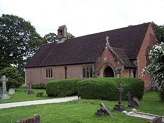
Evington is an Electoral ward and administrative division of the city of Leicester, England. It used to be a small village centred on Main Street and the Anglican church of St Denys but was close enough to Leicester to become one of the outer suburbs in the 1930s. Today, the ward comprises the historical village of Evington, as well as the modern ex-council estates of Rowlatts Hill and Goodwood. The population of the ward at the 2011 census was 11,133.

Woodlands, Dorset Human settlement in England

Woodlands is a village and civil parish in the East Dorset district of Dorset, South-West England. It is five miles (8 km) north of Wimborne Minster. Horton Road is the main road going through the parish.

Lenham Human settlement in England

Lenham is a market village and civil parish in Kent situated on the southern edge of the North Downs, 9 miles (14 km) east of Maidstone. The picturesque square in the village has two public houses, a couple of restaurants, and a tea-room. Lenham has a population of 3,370 according to the 2011 Census.

Knockholt is a village and civil parish in the Sevenoaks District of Kent, England. It is located 5 mi (8 km) north west of Sevenoaks & 5.7 mi (9.2 km) south of Orpington, adjacent to the Kent border with Greater London.

Rickinghall Inferior Human settlement in England

Rickinghall Inferior is a civil parish in the Mid Suffolk district of Suffolk, England. According to the 2011 census there were 233 males and 216 females in this civil parish, for a total population of 449. It includes the western part of the village of Rickinghall and is adjacent to the village and parish of Wattisfield. The old road from the market town of Bury. St Edmunds to the City of Norwich and the town of Great Yarmouth passes through the centre of the village but the new road, the A143, uses a by-pass to the East.

Ashton, Devon Human settlement in England

Ashton is a civil parish in the Teignbridge district of Devon, England. According to the 2001 census it had a population of 174, and it had a population of 203 according to the 2011 census. The parish consists of two villages, Higher Ashton and Lower Ashton, and is on the edge of the Dartmoor National Park. The France Brook flows through most of Ashton just south of its main road, and along Ashton's eastern boundary flows the River Teign. The parish is located approximately 13 km north of Newton Abbot, and roughly 10 km to the south west of its nearest city, Exeter. Historically, Ashton has primarily been based inside the agricultural sector, but one of its most notifiable landmarks is the St John the Baptists church located in the Higher Ashton district.

Barham, Kent Human settlement in England

Barham is a village and civil parish in the City of Canterbury district of Kent, England. Barham village is approximately 6 miles (10 km) south-east from Canterbury and 8 miles (13 km) north from Folkestone.

Birling, Kent Human settlement in England

Birling is a village and civil parish in the Tonbridge and Malling district of Kent, England, about seven miles west of Maidstone. According to the 2001 census it had a population of 430 increasing to 437 at the 2011 Census: 224 male and 213 female. It is south-west of the nearby town of Snodland and 37 miles away from the capital.

Knodishall Village in Suffolk, England

Knodishall, a village in Suffolk, England, lies 3.5 miles (6 km) south-east of Saxmundham, 1 mile (2 km) south-west of Leiston, and 3 miles from the coast, in the Blything Hundred. Most dwellings are now at Coldfair Green; just a few remain in the original village by the parish Church of St Lawrence, which falls gently on the north side of the Hundred River valley. It is now an outlier of Knodishall Common, a settlement a mile to the south-east. The estimated parish population was 790 in 2019.

Elmstead Market Human settlement in England

Elmstead Market is a village in the civil parish of Elmstead, in the Tendring district of Essex, England. It lies 3 km north-east of Wivenhoe and 6 km east of Colchester. It is on the A133 road which runs to Clacton-on-Sea to the south-east and Colchester to the west. In 2018 it had an estimated population of 1,684.

Sundridge with Ide Hill Human settlement in England

Sundridge and Ide Hill is a civil parish in the Sevenoaks District of Kent, England. It is located in the Darenth valley and lies between Sevenoaks and Westerham. The parish contains the villages of Sundridge and Ide Hill and the hamlet of Goathurst Common. It lies within the Kent Downs Area of Outstanding Natural Beauty and within London’s Metropolitan Green Belt. It is approximately 21 miles south of London.

Parham, Suffolk Village and civil parish in Suffolk, England

Parham is a village and civil parish in the East Suffolk district of Suffolk in eastern England. Located seven miles north of Woodbridge, in 2005 it had a population of 300, reducing to 263 at the 2011 census and according to the 2011 census there were 129 males and 134 females living at this time.

Wacton, Norfolk Human settlement in England

Wacton is a village in the English county of Norfolk. It is located about one mile south-west of Long Stratton and 13 miles (21 km) south west of Norwich. It covers an area of 4.54 km2 (1.75 sq mi) and has a population of 302 people as of the last census in 2011

Lower Hardres Human settlement in England

Lower Hardres is a village and former civil parish, now in the parish of Lower Hardres and Nackington, in the City of Canterbury District of Kent, England.

Out Rawcliffe Human settlement in England

Out Rawcliffe is a village and civil parish on the north bank of the River Wyre in the Over Wyre area of the Fylde in Lancashire, England. The population of the civil parish taken at the 2011 census was 626.

Guston, Kent Human settlement in England

Guston is a village and civil parish in the Dover district of Kent, in South East England. The village lies about a quarter of a mile north of the campus of the Duke of York's Royal Military School, near Martin Mill. In the 1950s the village was the site of a public house, a post office, a Saxon church and approximately one-hundred homes. There is also a windmill present, which has been converted into a house. Nearby villages include Whitfield, East Langdon, Pineham and Buckland. The River Dour is approximately 2.71 km away from Guston, and there is easy access to main roads, with the A2 and A258 running around and through the village.

Leaveland Human settlement in England

Leaveland is a hamlet and civil parish located in the Swale borough of Kent, South East England. In terms of topography, it is described as a "village surrounded by inhabited countryside", and is situated mostly on high ground. It is located 5 miles South of Faversham, West of Badlesmere, and the A251.The closest train station to the area is Selling, which is 5.45 km away. The closest estuary is The Swale which separates the Isle of Sheppey from mainland Kent, and flows through Faversham. Leaveland itself covers an area of 1.5 km2.

Hunton, Kent Human settlement in England

Hunton is a civil parish and village near the town of Maidstone in Kent, England.

Langdon, Kent Human settlement in England

Langdon is a civil parish in the Dover district of Kent, England, and contains the villages of East Langdon and West Langdon, and the hamlets of Martin and Martin Mill. Langdon was the site of Langdon Abbey which was dissolved in 1535.

Sir William Honywood, 2nd Baronet was an English politician who sat in the House of Commons from 1685 to 1695.

References

  1. "Elmsted ParishCouncil". Archived from the original on 14 March 2008. Retrieved 9 October 2008.
  2. 1 2 The Church of England. "St James the Great, Elmsted". A Church Near You. The Church of England. Retrieved 28 March 2017.
  3. 1 2 3 British History Online. "Elmsted". British History Online. Retrieved 1 March 2017.
  4. Kent County Council. "Council – Elmsted Parish Council". www.elmstedpc.kentparishes.gov.uk. Retrieved 3 May 2017.
  5. Lior (10 November 2011). "Meaning of Place Names: Why do we call places by certain names?". www.saywhydoi.com. Retrieved 3 May 2017.
  6. Johal, Dilwiner Singh (25 October 2013). "Scattered Settlement Patterns". prezi.com. Retrieved 3 May 2017.
  7. University of Portsmouth. "Boundary Map of Elmsted". www.visionofbritain.org.uk. Retrieved 3 May 2017.
  8. Google. "Google Maps". Google Maps. Retrieved 28 March 2017.{{cite web}}: |last= has generic name (help)
  9. Bodsham School. "Bodsham School - Home". www.bodsham.kent.sch.uk. Retrieved 28 March 2017.
  10. Department for education. "Bodsham Church of England Primary School". Department for Education.
  11. Elentari. "The Romans in Britain: Trade and Travel". h2g2.com. Retrieved 28 March 2017.
  12. 1 2 3 4 The Wye Group of Churches. "St James the Great, Elmsted". united-wye-benefice. Retrieved 28 March 2017.
  13. Bartholomew, John (1887). Descriptive Gazetteer Entry for Elmsted. Gazetteer of the British Isles.
  14. Sillitoe, Neil (14 April 2008). "Dwellings, Household Spaces and Accommodation Type, 2011 (KS401EW)". www.neighbourhood.statistics.gov.uk. Retrieved 28 March 2017.
  15. University of Portsmouth. "Elmsted total households". www.visionofbritain.org.uk. Retrieved 2 May 2017.
  16. Guffogg, Julian P. "Geograph St James the Great church, Elmstead". www.geograph.org.uk. Retrieved 3 May 2017.
  17. Historic England. "CHURCH OF ST JAMES - 1241752| Historic England". historicengland.org.uk. Retrieved 31 March 2017.
  18. British Listed Buildings retrieved 20 July 2013
  19. 1 2 Guffogg, Julian. "Interior, St James the Great church, Elmstead". Geograph.
  20. Love, Dickon. "Elmsted, St James the Great". Lovers Guide to the church bells of Kent.
  21. Hasted, Edward (1799). "Elmsted". British History Online. Retrieved 21 March 2017.
  22. Hinson, Colin. "Elmsted". GENUKI. Retrieved 22 March 2017.
  23. University of Portsmouth. "Elmsted Occupation data 1881". www.visionofbritain.org.uk. Retrieved 3 May 2017.
  24. University of Portsmouth. "Elmsted Total Population". www.visionofbritain.org.uk. Retrieved 28 March 2017.
  25. 1 2 Neighbourhood Statistics. "Elmsted : Key Figures for 2011 Census: Key Statistics". Neighbourhood Statistics. Office for National Statistics. Retrieved 2 February 2017.
  26. Sillitoe, Neil (14 April 2008). "Age Structure, 2011". www.neighbourhood.statistics.gov.uk. Retrieved 28 March 2017.
  27. Sillitoe, Neil (14 April 2008). "Key Figures for 2011 Census: Key Statistics". www.neighbourhood.statistics.gov.uk. Retrieved 28 March 2017.