Empty diagonal

Last updated
France's population density by department. The broken lines mark the approximate boundaries of the empty diagonal. The solid line is the Le Havre-Marseille line, to the east of which lives 60% of the French population. Carte demographique de la France.svg
France's population density by department. The broken lines mark the approximate boundaries of the empty diagonal. The solid line is the Le Havre–Marseille line, to the east of which lives 60% of the French population.

The empty diagonal (French : diagonale du vide) is a band of low-density population that stretches from the French department of the Landes in the southwest to the Meuse in the northeast. The diagonal's population density is very low compared to the rest of France.

Contents

Description

The low population density (less than 30/km², or 78/mi²) is caused largely by the rural exodus and urbanisation of the 19th and 20th centuries. Some commentators [1] prefer to speak of a "low-density diagonal" (diagonale des faibles densités) and regard the term "empty diagonal" as both pejorative and exaggerated. Still, DATAR [2] used the term and it remains the most common term.

The pattern is more readily apparent at the departmental level than at the regional level. [3] [4] It is part of a broader pattern of low population density that extends into Spain and Portugal and is known as the continental diagonal. [5] [6]

History and evolution

Before the emergence of the empty diagonal, an earlier demographic feature was the Saint-Malo-Geneva line that ran from the northwest to the southeast and divided the industrial northeast from the agrarian southwest. Charles Dupin identified it in his 1837 treatise Forces productives et commerciales de la France.[ citation needed ]

In 1947, the geographer Jean-François Gravier wrote of a "French desert" that corresponds, more or less, to the modern notion of the empty diagonal.[ citation needed ]

Hervé Le Bras and Emmanuel Todd argue that the concept is no longer valid in the 21st century because of growth that is observed in some departments like Indre and Gers. [7] According to their analysis, the zone of negligible or negative population growth extends only from the Massif Central to Lorraine. However, an analysis at the level of cantons and communes indicates that the zone of decline extends beyond the Massif–Lorraine axis [8] and that the growth observed by Le Bras and Todd is fragile and driven by a temporary influx of retirees.[ citation needed ]

Literature

La diagonale du vide is the title of a 2009 novel by Pierre Péju [9] in which an urban businessman seeks solitude in a cottage in Ardèche.

From 2015 to 2016, the author and blogger Mathieu Mouillet spent 18 months exploring the empty diagonal and meeting its inhabitants. His "exotic voyage" is presented by notes and photographs on his blog. [10]

See also

Related Research Articles

<span class="mw-page-title-main">Lozère</span> Department of France in Occitanie

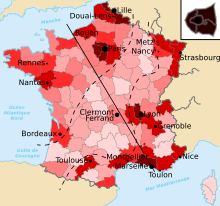
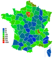
Lozère is a landlocked department in the region of Occitanie in Southern France, located near the Massif Central, bounded to the northeast by Haute-Loire, to the east by Ardèche, to the south by Gard, to the west by Aveyron, and the northwest by Cantal. It is named after Mont Lozère. With 76,604 inhabitants as of 2019, Lozère is the least populous French department.

<span class="mw-page-title-main">Hautes-Alpes</span> Department in Provence-Alpes-Côte dAzur, France

Hautes-Alpes is a department in the Provence-Alpes-Côte d'Azur region of Southeastern France. It is located in the heart of the French Alps, after which it is named. Hautes-Alpes had a population of 141,220 as of 2019, which makes it the third least populated French department. Its prefecture is Gap; its sole subprefecture is Briançon. Its INSEE and postal code is 05.

<span class="mw-page-title-main">Savoie</span> Department in Auvergne-Rhône-Alpes, France

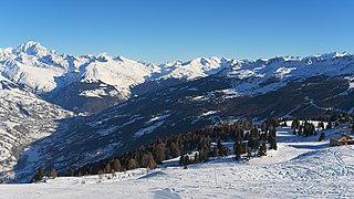
Savoie is a department in the Auvergne-Rhône-Alpes region, Southeastern France. Located in the French Alps, its prefecture is Chambéry. In 2019, Savoie had a population of 436,434.

<span class="mw-page-title-main">Cantal</span> Department in Auvergne-Rhône-Alpes, France

Cantal is a rural department in the Auvergne-Rhône-Alpes region of France, with its prefecture in Aurillac. Its other principal towns are Saint-Flour and Mauriac; its residents are known as Cantalians. Cantal borders the departments of Puy-de-Dôme, Haute-Loire, Aveyron, Lot, Lozère and Corrèze, in the Massif Central natural region.

<span class="mw-page-title-main">Creuse</span> Department of France

Creuse is a department in central France named after the river Creuse. After Lozère, it is the second least populated department in France. It is bordered by Indre and Cher to the north, Allier and Puy-de-Dôme to the east, Corrèze to the south, and Haute-Vienne to the west. In 2020, the population of this department is 115,995, while the official estimates in 2022 is 113,711.

<span class="mw-page-title-main">Haute-Saône</span> Department of France in Bourgogne-Franche-Comté

Haute-Saône is a department in the Bourgogne-Franche-Comté region of northeastern France. Named after the river Saône, it had a population of 235,313 in 2019. Its prefecture is Vesoul; its sole subprefecture is Lure.

<span class="mw-page-title-main">Yonne</span> Department in Bourgogne-Franche-Comté, France

Yonne is a département in the Bourgogne-Franche-Comté region in France. It is named after the river Yonne, which flows through it, in the country's north-central part. One of Bourgogne-Franche-Comté's eight constituent departments, it is located in its northwestern part, bordering Île-de-France. It was created in 1790 during the French Revolution. Its prefecture is Auxerre, with subprefectures in Avallon and Sens. Its INSEE and postcode number is 89.

<span class="mw-page-title-main">Saint-Jean-de-Maurienne</span> Subprefecture of Savoie, Auvergne-Rhône-Alpes, France

Saint-Jean-de-Maurienne is a subprefecture of the Savoie department, in the region of Auvergne-Rhône-Alpes, Southeastern France.

<span class="mw-page-title-main">Paul Vidal de La Blache</span> French geographer

Paul Vidal de La Blache was a French geographer. He is considered to be the founder of modern French geography and also the founder of the French School of Geopolitics. He conceived the idea of genre de vie, which is the belief that the lifestyle of a particular region reflects the economic, social, ideological and psychological identities imprinted on the landscape.

<span class="mw-page-title-main">Eaux-Bonnes</span> Commune in Nouvelle-Aquitaine, France

Eaux-Bonnes is a commune in the Pyrénées-Atlantiques department in south-western France.

<span class="mw-page-title-main">Saint-Avé</span> Commune in Brittany, France

Saint-Avé is a commune in the Morbihan department of Brittany in north-western France. It's the 8th most populated commune of the Morbihan department and the 32nd of the Brittany region with its population of 11,787 inhabitants in 2018.

<span class="mw-page-title-main">L'Albère</span> Commune in Occitania, France

L'Albère is a commune in the Pyrénées-Orientales department in southern France.

<span class="mw-page-title-main">Maxilly-sur-Saône</span> Commune in Bourgogne-Franche-Comté, France

Maxilly-sur-Saône is a commune in the Côte-d'Or department in the Bourgogne-Franche-Comté region in eastern France. The inhabitants are called Maximilliens and Maximilliennes.

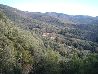
Talasani is a rural commune and village on the eastern seaboard of Corsica, in the Haute-Corse department of France. The area has a very low population density and mainly comprises forests and farmland. As a coastal municipality, Talasani enforces strict urban planning provisions in order to preserve the ecological balance of the coast.

<span class="mw-page-title-main">La Meilleraye-de-Bretagne</span> Commune in Pays de la Loire, France

La Meilleraye-de-Bretagne is a commune in the Loire-Atlantique department in western France.

<span class="mw-page-title-main">Les Moutiers-en-Retz</span> Commune in Pays de la Loire, France

Les Moutiers-en-Retz is a commune in the Loire-Atlantique department in western France.

Champvoisy is a commune in the Marne department in north-eastern France. It is a rural municipality, with a very low population density. The municipality is part of the functional area of Reims, which is composed of 294 municipalities.

<span class="mw-page-title-main">Jean-Hervé Lorenzi</span> French economist

Jean-Hervé Lorenzi is a French economist.

<span class="mw-page-title-main">Hervé Le Bras</span> French demographer and historian (born 1943)

Hervé Le Bras is a French demographer and historian.

<span class="mw-page-title-main">Hubert Boulard</span> French comic book author

Hubert Boulard was a French comics writer and colorist usually credited mononymously as "Hubert".

References

  1. Jean-Claude Bontron (1976). La France des faibles densités, II: Documentation bibliographique, Analyses d'études. SEGESA-ACEAR.
  2. Gilles Fumey (2009-10-26). "La France en diagonales" (PDF). Retrieved 18 July 2016..
  3. "Le Massif Central: au cœur de la diagonale du vide".
  4. "La France: des territoires en mutation".
  5. Rozenblat, C. "Tissu d'un semi de villes européennes" (PDF).
  6. Yoann Doignon; Sébastien Oliveau; Isabelle Blöss-Widmer (2016). "L'Europe méridionale depuis 20 ans: dépeuplement, dépopulation et renouveau démographique". Espace, Populations, Sociétés (2015/3–2016/1). doi: 10.4000/eps.6171 .
  7. Hervé Le Bras; Emmanuel Todd (2013). Le Mystère français. Seuil. ISBN   9782021102161.
  8. Yoann Doignon; Sébastien Oliveau (20 January 2016). "Is the French diagonal emptying? An exploratory spatial analysis of demographic decrease in France for the past 50 years". European Journal of Geography. doi: 10.4000/cybergeo.31641 . (translated from "La diagonale se vide? Analyse spatiale exploratoire des décroissances démographiques en France métropolitaine depuis 50 ans", doi : 10.4000/cybergeo.27439)
  9. Pierre Péju (2009). La diagonale du vide. Éditions Gallimard, Collection Blanche. ISBN   9782070781034.
  10. Mathieu Mouillet. "La diagonale du vide".