Related Research Articles

The Amu Darya, also called the Amu, the Amo, and historically the Oxus, is a major river in Central Asia and Afghanistan. Rising in the Pamir Mountains, north of the Hindu Kush, the Amu Darya is formed by the confluence of the Vakhsh and Panj rivers, in the Tigrovaya Balka Nature Reserve on the border between Afghanistan and Tajikistan, and flows from there north-westwards into the southern remnants of the Aral Sea. In its upper course, the river forms part of Afghanistan's northern border with Tajikistan, Uzbekistan, and Turkmenistan. In ancient history, the river was regarded as the boundary of Greater Iran with Turan, which roughly corresponded to present-day Central Asia. The Amu Darya has a flow of about 70 cubic kilometres per year on average.

Kazakhstan is located in Central Asia. With an area of about 2,724,900 square kilometers (1,052,100 sq mi) Kazakhstan is more than twice the combined size of the other four Central Asian states and 60% larger than Alaska. The country borders Turkmenistan, Uzbekistan, and Kyrgyzstan to the south; Russia to the north; Russia and the Caspian Sea to the west; and China's Xinjiang Uygur Autonomous Region to the east.
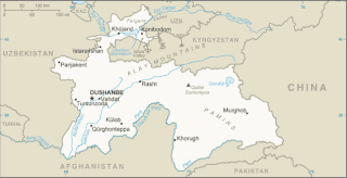
Tajikistan is nestled between Kyrgyzstan and Uzbekistan to the north and west, China to the east, and Afghanistan to the south. Mountains cover 93 percent of Tajikistan's surface area. The two principal ranges, the Pamir Mountains and the Alay Mountains, give rise to many glacier-fed streams and rivers, which have been used to irrigate farmlands since ancient times. Central Asia's other major mountain range, the Tian Shan, skirts northern Tajikistan. Mountainous terrain separates Tajikistan's two population centers, which are in the lowlands of the southern and northern sections of the country. Especially in areas of intensive agricultural and industrial activity, the Soviet Union's natural resource utilization policies left independent Tajikistan with a legacy of environmental problems.
Turkmenistan is a landlocked country in Central Asia, bordering the Caspian Sea to the west, Iran and Afghanistan to the south, Uzbekistan to the north-east, and Kazakhstan to the north-west. It is the southernmost republic of the Commonwealth of Independent States (CIS), the loose federation created at the end of 1991 by most of the Post-Soviet states.
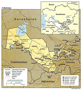
Uzbekistan is a country in Central Asia, located north of Turkmenistan and Afghanistan. With an area of 447,000 square kilometers, Uzbekistan stretches 1,425 km (885 mi) from west to east and 930 km (580 mi) from north to south. It borders Turkmenistan to the southwest, Kazakhstan to the north and Tajikistan and Kyrgyzstan to the south and east. Uzbekistan also has four small exclaves in Turkmenistan.

The Aral Sea was an endorheic lake lying between Kazakhstan to its north and Uzbekistan to its south which began shrinking in the 1960s and largely dried up by the 2010s. It was in the Aktobe and Kyzylorda regions of Kazakhstan and the Karakalpakstan autonomous region of Uzbekistan. The name roughly translates from Mongolic and Turkic languages to "Sea of Islands", a reference to the large number of islands that once dotted its waters. The Aral Sea drainage basin encompasses Uzbekistan and parts of Afghanistan, Iran, Kazakhstan, Kyrgyzstan, Tajikistan, and Turkmenistan.

The Karakum Desert, also spelled Kara-Kum and Gara-Gum, is a desert in Central Asia. The name refers to the shale-rich sand beneath the surface. It occupies about 70 percent, or roughly 350,000 km2 (140,000 sq mi), of Turkmenistan.
Karakalpakstan, officially the Republic of Karakalpakstan, is an autonomous republic of Uzbekistan. It spans the northwestern portion of Uzbekistan. The capital is Nukus. Karakalpakstan covers an area of 166,590 km2 (64,320 sq mi), and has a population of about 2 million people. Its territory covers the classical land of Khwarezm, which in classical Persian literature was known as Kāt (کات).
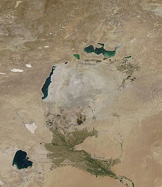
The Aralkum Desert is a desert that has appeared since 1960 on the seabed once occupied by the Aral Sea. It lies to the south and east of what remains of the Eastern Basin Aral Sea in Uzbekistan and Kazakhstan. It is currently the youngest desert in the world.

The Karakum Canal in Turkmenistan is one of the largest irrigation and water supply canals in the world. Started in 1954, and completed in 1988, it is navigable over much of its 1,375-kilometre (854 mi) length, and carries 13 cubic kilometres (3.1 cu mi) of water annually from the Amu-Darya River across the Karakum Desert in Turkmenistan. The canal opened up huge new tracts of land to agriculture, especially to cotton monoculture heavily promoted by the Soviet Union, and supplying Ashgabat with a major source of water. The canal is also a major factor leading to the Aral Sea environmental disaster. The Soviet regime planned to at some time extend the canal to the Caspian Sea.
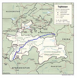
The Vakhsh, also known as the Surkhob, in north-central Tajikistan, and the Kyzyl-Suu, in Kyrgyzstan, is a Central Asian river, and one of the main rivers of Tajikistan. It is a tributary of the Amu Darya river.

The Sarygamysh Lake, also Sarykamysh or Sary-Kamysh, is a lake in Central Asia. It is about midway between the Caspian Sea and the Aral Sea. It is the largest lake in Turkmenistan, in which three quarters of the entire lake's area is located. The Sarykamysh basin and the Sarykamysh delta of the Amu Darya river are physical and geographical nature regions of the Dashoguz Region of Turkmenistan.
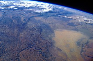
Environmental issues in Tajikistan include concentrations of agricultural chemicals and salts in the soil and groundwater, poor management of water resources, and soil erosion. Additionally, because of inadequate sanitation facilities, untreated industrial waste and sewage combine with agricultural runoff to cause water pollution in the Aral Sea Basin. Soviet-Era mining operations in Tajikistan extracted and processed uranium, gold, antimony, tungsten, mercury, and molybdenum, each of which is known to leave toxic waste that also threatens water quality. Pockets of high air pollution caused by industry and motor vehicles have resulted in Tajikistan ranking 133rd in the world in greenhouse gas emissions. Air pollution is a particular problem during times of the year when atmospheric conditions hold industrial and vehicle emissions close to the surface in urban areas. In summer, dust and sand from the deserts of Uzbekistan and Turkmenistan cause air pollution across the entire southwestern lowland region.

The Aydar Lake is part of the man-made Aydar-Arnasay system of lakes, which covers 4,000 square kilometres (1,500 mi2). This has 3 brackish water lakes, deep basins of the south-eastern Kyzyl Kum. The lakes are expansive reservoirs of Soviet planning.

The dwarf sturgeon, little shovelnose sturgeon, or small Amu-Darya shovelnose sturgeon is a species of fish in the family Acipenseridae. It is found in Turkmenistan, Uzbekistan and probably in Tajikistan.

The Uzboy was a distributary of the Amu Darya which flowed through the northwestern part of the Karakum Desert of Turkmenistan until the 17th century, when it abruptly dried up, eliminating the agricultural population that had thrived along its banks..
After irrigation projects diverted water from the Aral Sea it began to dry up and left behind salts, other minerals, and toxins in the soil. These not only contaminated the soil but also were picked up by winds and storms, and traveled to other areas, including over crop lands. This has led to increased health problems like respiratory diseases and cancers, among others. The change in the size of the Aral has also affected the local climate and resulted in increased occurrence and worsening of storms.

The Main Turkmen Canal was a large-scale irrigation project in the Turkmen Soviet Socialist Republic. The canal was intended to transport water from the Amu Darya river to Krasnovodsk, a city in Turkmenistan on the coast of the Caspian Sea. The canal was going to use the course of the ancient dry Uzboy River bed.
Delta Blues (In a Land of Cotton) is a 2001 documentary film. The movie deals with the environmental problems emanating from the drying up of the Aral Sea, and the impact this has on political relationships in the Central Asian region (especially Uzbekistan, Kazakhstan, Kyrgyzstan, and Turkmenistan). In particular, it focuses on the document Water-related vision for the Aral Sea basin for the year 2025 by UNESCO, as presented in 2000 at the 2nd World Water Forum in The Hague. This document has been criticized for setting unrealistic goals, and also, by focusing on the entire basin (south-west Kazakhstan, Uzbekistan, Turkmenistan), for implicitly giving up on the Aral Sea and the people living downstream in Karakalpakstan.

Lake Aibugir is a lake in northern Daşoguz Province, Turkmenistan as part of the Amu Darya Plain. It is 77 km from the nearest district, Köneürgenç.
References
- ↑ "Turkmenistan combating desertification". AzerNews.az. 2017-06-20. Retrieved 2021-08-12.
- ↑ "Environmental issues in Turkmenistan". naturvernforbundet.no (in Norwegian). Archived from the original on 2021-08-12. Retrieved 2021-08-12.
- ↑ "World of Change: Shrinking Aral Sea". earthobservatory.nasa.gov. 2014-09-24. Retrieved 2021-08-12.
- ↑ "The Aral Sea Crisis". www.columbia.edu. Retrieved 2021-08-12.
- ↑ Wæhler, Turid Austin; Dietrichs, Erik Sveberg (2017-10-02). "The vanishing Aral Sea: health consequences of an environmental disaster". Tidsskrift for den Norske Legeforening. 137 (18). doi: 10.4045/tidsskr.17.0597 . ISSN 0029-2001. PMID 28972331.
- ↑ "Turkmenistan: Going south fast". Eurasianet. Apr 25, 2023. Retrieved 25 April 2023.
- ↑ K.R.Masilamani · (2020-11-06). "World's largest stockpiles of toxic pesticides buried in Central Asia". The Third Pole. Retrieved 2021-08-12.
- 1 2 Carrington, Damian (2023-05-09). "'Mind-boggling' methane emissions from Turkmenistan revealed". The Guardian. ISSN 0261-3077 . Retrieved 2023-05-09.
- ↑ "Turkmenistan expands international cooperation in environmental protection". AzerNews.az. 2020-03-01. Retrieved 2021-08-12.
- ↑ "OSCE promotes environmental awareness in Turkmenistan". osce.org . Retrieved 2021-08-12.