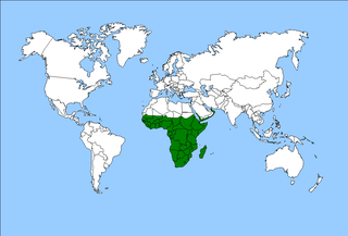
The Afrotropical realm is one of the Earth's eight biogeographic realms. It includes Sub-Saharan Africa, the southern Arabian Peninsula, the island of Madagascar, and the islands of the western Indian Ocean. It was formerly known as the Ethiopian Zone or Ethiopian Region.

The Eastern Highlands, also known as the Manica Highlands, is a mountain range on the border of Zimbabwe and Mozambique. The Eastern Highlands extend north and south for about 300 kilometres (190 mi) through Zimbabwe's Manicaland Province and Mozambique's Manica Province.

The Madagascar subhumid forests are a tropical moist broadleaf forest ecoregion that covers most of the Central Highlands of the island of Madagascar. They are included in the WWF's Global 200 list of outstanding ecoregions. Most of the original habitats have been lost due to human pressure.

The Ethiopian Highlands is a rugged mass of mountains in Ethiopia in Northeast Africa. It forms the largest continuous area of its elevation in the continent, with little of its surface falling below 1,500 m (4,900 ft), while the summits reach heights of up to 4,550 m (14,930 ft). It is sometimes called the "Roof of Northeastern Africa" due to its height and large area. It is the only country in the region with such a high elevated surface. This elevated surface is bisected diagonally by the Great East African Rift System which extends from Syria to Mozambique across the East African Lakes. Most of the Ethiopian Highlands are part of central and northern Ethiopia, and its northernmost portion reaches into Eritrea.

The Serengeti volcanic grasslands is a tropical grassland ecoregion of Tanzania. The Serengeti volcanic grasslands are distinctive grasslands growing on deposits of volcanic ash in northern Tanzania. It includes the eastern portion of Serengeti National Park and areas south and east of the Ngorongoro Highlands.

The Maputaland-Pondoland bushland and thickets is one of the ecoregions of South Africa. It consists of the montane shrubland biome.
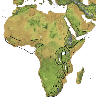
The Afromontane regions are subregions of the Afrotropical realm, one of the Earth's eight biogeographic realms, covering the plant and animal species found in the mountains of Africa and the southern Arabian Peninsula. The Afromontane regions of Africa are discontinuous, separated from each other by lower-lying areas, and are sometimes referred to as the Afromontane archipelago, as their distribution is analogous to a series of sky islands.

The Coastal forests of eastern Africa, also known as the East African Coastal Forests or Zanzibar–Inhambane forests, is a tropical moist forest region along the east coast of Africa. The region was designated a biodiversity hotspot by Conservation International.

The Southern Zanzibar–Inhambane coastal forest mosaic, also known as the Southern Swahili coastal forests and woodlands, is a tropical moist broadleaf forest ecoregion of eastern Africa. It is a southern variation of Northern Zanzibar-Inhambane coastal forest mosaic. The ecoregion supports habitats of forest, savanna and swamps. The southern portion of the ecoregion is not as well studied due to the 1977-1992 civil war in Mozambique.
The Angolan montane forest-grassland mosaic ecoregion is located on the east-facing inland side of the belt of mountains that stands parallel to the coast of Angola, 50–100 km inland.

The Ethiopian montane grasslands and woodlands is a montane grasslands and shrublands ecoregion in Ethiopia. It occupies the middle elevations of the Ethiopian Highlands, between the high-altitude Ethiopian montane moorlands and the lower-elevation Ethiopian montane forests.

The East African montane forests is a montane tropical moist forest ecoregion of eastern Africa. The ecoregion comprises several separate areas above 2000 meters in the mountains of South Sudan, Uganda, Kenya, and Tanzania.

The Mbulu Highlands is a plateau in north-central Tanzania.

Northern Zanzibar–Inhambane coastal forest mosaic, also known as the Northern Swahili coastal forests and woodlands, is a tropical moist broadleaf forest ecoregion of coastal East Africa. The ecoregion includes a variety of habitats, including forest, savanna and swamps.

The Ruwenzori-Virunga montane moorlands is a montane grasslands and shrublands ecoregion of the Rwenzori Mountains and Virunga Mountains in central Africa.
The Northern Acacia–Commiphora bushlands and thickets are a tropical grasslands, savannas and shrublands ecoregion in eastern Africa. The ecoregion is mostly located in Kenya, extending north into southeastern South Sudan, northeastern Uganda and southwestern Ethiopia and south into Tanzania along the Kenya-Tanzania border.

The Somali Acacia–Commiphora bushlands and thickets is a semi-arid tropical grasslands, savannas, and shrublands ecoregion in the Horn of Africa. It is home to diverse communities of plants and animals, including several endemic species.

The Southwestern Arabian foothills savanna, also known as the Southwestern Arabian Escarpment shrublands and woodlands, is a desert and xeric shrubland ecoregion of the southern Arabian Peninsula, covering portions of Saudi Arabia, Yemen, and Oman.

The Victoria Basin forest–grassland mosaic is an ecoregion that lies mostly in Uganda and extends into neighboring countries. The ecoregion is centered north and west of Lake Victoria, with an outlier on the border of Ethiopia and South Sudan.
