
The European Environment Agency (EEA) is the agency of the European Union (EU) which provides independent information on the environment.
A hydrographic office is an organization which is devoted to acquiring and publishing hydrographic information.

The terms international waters or transboundary waters apply where any of the following types of bodies of water transcend international boundaries: oceans, large marine ecosystems, enclosed or semi-enclosed regional seas and estuaries, rivers, lakes, groundwater systems (aquifers), and wetlands.
The Intergovernmental Oceanographic Commission of UNESCO (IOC/UNESCO) was established by resolution 2.31 adopted by the General Conference of the United Nations Educational, Scientific and Cultural Organization (UNESCO). It first met in Paris at UNESCO Headquarters from 19 to 27 October 1961. Initially, 40 States became members of the commission. The IOC assists governments to address their individual and collective ocean and coastal management needs, through the sharing of knowledge, information and technology as well as through the co-ordination of programs and building capacity in ocean and coastal research, observations and services.
The National Ocean Service (NOS) is an office within the U.S. Department of Commerce, National Oceanic and Atmospheric Administration (NOAA). It is the responsible for preserving and enhancing the nation's coastal resources and ecosystems along approximately 95,000 miles (153,000 km) of shoreline, that is bordering 3,500,000 square miles (9,100,000 km2) of coastal, Great Lakes and ocean waters. Its mission is to "provide science-based solutions through collaborative partnerships to address the evolving economic, environmental, and social pressures on our oceans and coasts." The offices works with partnered agencies to ensure that the ocean and coastal areas are safe, healthy, and productive. It`s projects focus on working to ensure the safe and efficient marine transportation, promoting the protection of coastal communities, conserving marine and coastal places. It employs 1,700 scientists, natural resource managers, and specialists in many different fields. The National Ocean Service was previously also known as the National Ocean Survey until it was renamed in 1983.
The Global Earth Observation System of Systems (GEOSS) was built by the Group on Earth Observations (GEO) on the basis of a 10-Year Implementation Plan running from 2005 to 2015. GEOSS seeks to connect the producers of environmental data and decision-support tools with the end users of these products, with the aim of enhancing the relevance of Earth observations to global issues. GEOSS aims to produce a global public infrastructure that generates comprehensive, near-real-time environmental data, information and analyses for a wide range of users. The Secretariat Director of Geoss is Barbara Ryan.
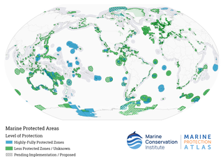
Marine protected areas (MPA) are protected areas of the world's seas, oceans, estuaries or in the US, the Great Lakes. These marine areas can come in many forms ranging from wildlife refuges to research facilities. MPAs restrict human activity for a conservation purpose, typically to protect natural or cultural resources. Such marine resources are protected by local, state, territorial, native, regional, national, or international authorities and differ substantially among and between nations. This variation includes different limitations on development, fishing practices, fishing seasons and catch limits, moorings and bans on removing or disrupting marine life. In some situations, MPAs also provide revenue for countries, potentially equal to the income that they would have if they were to grant companies permissions to fish. The value of MPA to mobile species is unknown.

Geoscience Australia is an agency of the Australian Government. It carries out geoscientific research. The agency is the government's technical adviser on all aspects of geoscience, and custodian of the geographic and geological data and knowledge of the nation.
Integrated coastal zone management (ICZM), integrated coastal management (ICM), or integrated coastal planning is a coastal management process for the management of the coast using an integrated approach, regarding all aspects of the coastal zone, including geographical and political boundaries, in an attempt to achieve sustainability. This concept was born in 1992 during the Earth Summit of Rio de Janeiro. The specifics regarding ICZM is set out in the proceedings of the summit within Agenda 21, Chapter 17.

Copernicus is the Earth observation component of the European Union Space Programme, managed by the European Commission and implemented in partnership with the EU Member States, the European Space Agency (ESA), the European Organisation for the Exploitation of Meteorological Satellites (EUMETSAT), the European Centre for Medium-Range Weather Forecasts (ECMWF), the Joint Research Centre (JRC), the European Environment Agency (EEA), the European Maritime Safety Agency (EMSA), Frontex, SatCen and Mercator Océan.

Vessel Monitoring Systems (VMS) is a general term to describe systems that are used in commercial fishing to allow environmental and fisheries regulatory organizations to track and monitor the activities of fishing vessels. They are a key part of monitoring control and surveillance (MCS) programs at national and international levels. VMS may be used to monitor vessels in the territorial waters of a country or a subdivision of a country, or in the Exclusive Economic Zones (EEZ) that extend 200 nautical miles (370.4 km) from the coasts of many countries. VMS systems are used to improve the management and sustainability of the marine environment, through ensuring proper fishing practices and the prevention of illegal fishing, and thus protect and enhance the livelihoods of fishermen.
The Marine Institute is a state agency in Ireland that provides government, public agencies and the maritime industry with scientific, advisory and economic development services, aiming to inform policy-making, regulation and the sustainable management and growth of the country's marine resources. Founded in 1991 on foot of a 1974 report, the institute undertakes and promotes marine research and development. The agency's staff and operations are governed by a ministerially-appointed board. Based at its headquarters near Galway, it has an office in Dublin and two research vessels.
Marine spatial planning (MSP) is a process that brings together multiple users of the ocean – including energy, industry, government, conservation and recreation – to make informed and coordinated decisions about how to use marine resources sustainably. MSP generally uses maps to create a more comprehensive picture of a marine area – identifying where and how an ocean area is being used and what natural resources and habitat exist. It is similar to land-use planning, but for marine waters.

The State Oceanic Administration was an administrative agency subordinate to the Ministry of Land and Resources, responsible for the supervision and management of sea area in the People's Republic of China and coastal environmental protection, protecting national maritime rights and organizing scientific and technical research of its territorial waters. In March 2018, the 13th National People's Congress announced that the newly formed Ministry of Natural Resources will replace the functions of the Ministry of Land & Resources, State Oceanic Administration and the State Bureau of Surveying and Mapping.

The World Database on Protected Areas (WDPA) is the largest assembly of data on the world's terrestrial and marine protected areas, containing more than 260,000 protected areas as of August 2020, with records covering 245 countries and territories throughout the world. The WDPA is a joint venture between the United Nations Environment Programme World Conservation Monitoring Centre and the International Union for Conservation of Nature World Commission on Protected Areas.
Maritime domain awareness (MDA) is defined by the International Maritime Organization as the effective understanding of anything associated with the maritime domain that could impact the security, safety, economy, or environment. MDA is said to work as a ‘key enabler’ for other maritime security issues, such as anti-piracy patrols, in the way that in order to do effective patrols you need to have the ability of conducting effective MDA. The maritime domain is defined as all areas and things of, on, under, relating to, adjacent to, or bordering on a sea, ocean, or other navigable waterway, including all maritime-related activities, infrastructure, people, cargo, and vessels and other conveyances.
The European Marine Observation and Data Network (EMODnet) is a web portal that brings together marine data, data products and metadata from diverse sources within Europe in a uniform way. It was initiated by the European Commission in response to the EU Green Paper on Future Maritime Policy, launched in June 2006. The main purpose of EMODnet is to unlock fragmented and hidden marine data resources and to make these available to individuals and organisations without restriction, except in special cases. The primary motivation for EMODnet is to stimulate investment in sustainable coastal and offshore activities through improved access to quality-assured, standardised and harmonised marine data.

Coastal & Marine Union (EUCC) is a nonprofit organization with a membership of around 500 institutions, NGOs and experts, in 40 countries. Its network at large involves about 2500 professionals involved in coastal and marine management issues. Founded in 1989 with the aim of promoting coastal management by bridging the gap between scientists, environmentalists, site managers, planners and policy makers, it has grown into the largest network of coastal practitioners and experts in Europe, with 13 National Branches, an International Secretariat in Leiden, and offices in Barcelona (Spain), Biarritz (France), Warnemünde (Germany), Szczecin (Poland), Klaipeda (Lithuania) and Sliema (Malta). EUCC's working area is Europe and its neighbouring regions, especially the Black Sea and the Mediterranean.

Blue economy is a term in economics relating to the exploitation, preservation and regeneration of the marine environment. Its scope of interpretation varies among organizations. However, the term is generally used in the scope of international development when describing a sustainable development approach to coastal resources. This can include a wide range of economic sectors, from the more conventional fisheries, aquaculture, maritime transport, coastal, marine and maritime tourism, or other traditional uses, to more emergent activities such as coastal renewable energy, marine ecosystem services, seabed mining, and bioprospecting.
EcoOcean is an Israeli non-profit environmental organization that was founded in 2002, working to preserve the marine and coastal environments, by promoting marine research, education and community engagement.