Extreme points of North America

Last updated
North America Location North America.svg
North America

This is a list of the extreme points of North America : the points that are highest and lowest, and farther north, south, east or west than any other location on the continent. Some of these points are debatable, given the varying definitions of North America.

Contents

North America and surrounding islands

Continental North America

Highest points

Lowest points

Other points

Islands

Lakes


Rivers

Extreme points of North American countries

See also

Notes

  1. Pico de Orizaba is the highest point of Estado Libre y Soberano de Puebla, Estado Libre y Soberano de Veracruz de Ignacio de la Llave, and all of México
  2. The summit of Grays Peak is the highest point of the Front Range and the Continental Divide of North America.
  3. The summit elevation of Grays Peak includes an adjustment of +1.881 m (+6.2 ft) from NGVD 29 to NAVD 88.
  4. Volcán Tajumulco is the highest point of the Republic of Guatemala and all of Central America. Volcán Tajumulco is the southernmost and easternmost 4000 m (13,123-foot) summit of North America
  5. Gunnbjørn Fjeld is the highest point on the Island of Greenland, Kalaallit Nunaat, the Kingdom of Denmark, and the entire Arctic
  6. Pico Duarte is the highest point on the Island of Hispaniola, the Dominican Republic, and all the islands of the Caribbean Sea
  7. Furnace Creek in Death Valley, California, United States set the world record for the highest reliably reported ambient air temperature of 134 °F (56.7 °C) on July 10, 1913. This record has been eclipsed only once by a questionable reading of 136 °F (57.8 °C) recorded in 'Aziziya, Libya, on September 13, 1922.

Related Research Articles

<span class="mw-page-title-main">Geography of Greenland</span> Geography of the worlds largest island

Greenland is located between the Arctic Ocean and the North Atlantic Ocean, northeast of Canada and northwest of Iceland. The territory comprises the island of Greenland—the largest island in the world—and more than a hundred other smaller islands. Greenland has a 1.2 kilometre long border with Canada on Hans Island. A sparse population is confined to small settlements along certain sectors of the coast. Greenland possesses the world's second-largest ice sheet.

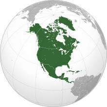
This is a list of the extreme points of The Americas, the points that are farther north, south, east or west than any other location on the continent. The continent's southernmost point is often said to be Cape Horn, which is the southernmost point of the Chilean islands. The Americas cross 134° of longitude east to west and 124° of latitude north to south.

This is a list of the extreme points of Central America, the points that are farther north, south, east, or west than any other location on the region. The list also included highest and lowest points and identifies the most extensive lake.

<span class="mw-page-title-main">Topographic isolation</span> Topography measuring minimum distance to a point of equal elevation

The topographic isolation of a summit is the minimum distance to a point of equal elevation, representing a radius of dominance in which the peak is the highest point. It can be calculated for small hills and islands as well as for major mountain peaks and can even be calculated for submarine summits.

This is a list of the extreme points of the Arctic, the points of Arctic lands that are farther to the north than any other location classified by continent and country, latitude and longitude, and distance to the North Pole. The list is sorted from north to south.

The following lists include the extreme and significant geographic points of the islands of the Caribbean Sea.

References

  1. Mark Newell; Blaine Horner (September 2, 2015). "New Elevation for Nation's Highest Peak" (Press release). USGS. Retrieved September 26, 2015.
  2. "Pico de Orizaba". Summits of the World. peakbagger.com. Retrieved September 8, 2012.
  3. "Grays Peak". NGS Station Datasheet. United States National Geodetic Survey . Retrieved September 8, 2012.
  4. "Grays Peak". Summits of the World. peakbagger.com. Retrieved September 8, 2012.
  5. "Volcán Tajumulco". Summits of the World. peakbagger.com. Retrieved January 11, 2010.
  6. "Gunnbjørn Fjeld". Summits of the World. peakbagger.com. Retrieved September 8, 2012.
  7. "Pico Duarte". Summits of the World. peakbagger.com. Retrieved January 2, 2010.
  8. "Highest and Lowest Elevations". United States Geological Survey . Retrieved April 26, 2021.

48°10′N100°10′W / 48.167°N 100.167°W / 48.167; -100.167 (North America)