Firth is a word in the English and Scots languages used to denote various coastal waters in the United Kingdom, predominantly within Scotland. In the Northern Isles, it more often refers to a smaller inlet. It is linguistically cognate to fjord, which has a more constrained sense in English. Bodies of water named "firths" tend to be more common on the Scottish east coast, or in the southwest of the country, although the Firth of Clyde is an exception to this. The Highland coast contains numerous estuaries, straits, and inlets of a similar kind, but not called "firth" ; instead, these are often called sea lochs. Before about 1850, the spelling "Frith" was more common.

Nigel Tranter OBE was a writer of a wide range of books on castles, particularly on themes of architecture and history. He also specialised in deeply researched historical novels that cover centuries of Scottish history.

East Lothian is one of the 32 council areas of Scotland, as well as a historic county, registration county and lieutenancy area. The county was called Haddingtonshire until 1921.

The Firth of Forth is the estuary, or firth, of several Scottish rivers including the River Forth. It meets the North Sea with Fife on the north coast and Lothian on the south.
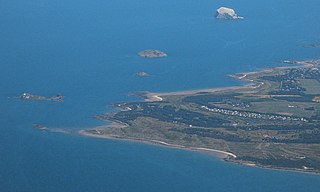
The Bass Rock, or simply the Bass, is an island in the outer part of the Firth of Forth in the east of Scotland. Approximately 2 km (1 mi) offshore, and 5 km (3 mi) north-east of North Berwick, it is a steep-sided volcanic plug, 107 m (351 ft) at its highest point, and is home to a large colony of gannets. The rock is uninhabited, but historically has been settled by an early Christian hermit, and later was the site of an important castle, which after the Commonwealth period was used as a prison. The island belongs to Hew Hamilton-Dalrymple, whose family acquired it in 1706, and before to the Lauder family for almost six centuries. The Bass Rock Lighthouse was constructed on the rock in 1902, and the remains of an ancient chapel survive.

Fidra is a currently uninhabited island in the Firth of Forth, 4 kilometres northwest of North Berwick, on the east coast of Scotland. The island is an RSPB Scotland nature reserve.

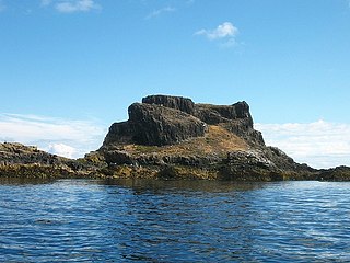
Lamb, sometimes called Lamb Island or The Lamb, is a small uninhabited island measuring approximately 100 by 50 metres, between the islands of Fidra and Craigleith in the Firth of Forth, off the east coast of Scotland. The Lamb is flanked by two "sheep dogs", North and South Dog Islands, which are basically small skerries. Like the other Islands of the Forth off North Berwick, the Lamb is a result of volcanic activity millions of years ago.
Aberlady is a coastal village in the Scottish council area of East Lothian. The village had an estimated population of 1,260 in 2020.

The River Almond is a river in Lothian, Scotland. It is approximately 28 miles (45 km) long, rising at Hirst Hill in Lanarkshire near Shotts, running through West Lothian and draining into the Firth of Forth at Cramond, Edinburgh. The name Almond/Amon is simply old Celtic for "river".

Gullane is a town on the southern shore of the Firth of Forth in East Lothian on the east coast of Scotland. There has been a church in the village since the ninth century. The ruins of the Old Church of St. Andrew built in the twelfth century can still be seen at the western entrance to the village; the church was abandoned after a series of sandstorms made it unusable, and Dirleton Parish Church took its place.

Muness Castle is located on Unst, which is one of the Shetland Islands of Scotland. The castle is 3 kilometres (1.9 mi) east of the village of Uyeasound. Unst is Scotland's most northerly inhabited island, and Muness is the most northerly fortalice in the British Isles. It was designated as a Scheduled monument in 1953 and is run as a museum by Historic Environment Scotland.

Dirleton is a village and civil parish in East Lothian, Scotland approximately 20 miles (32 km) east of Edinburgh on the A198. It contains 7,500 acres (30 km2). Dirleton lies between North Berwick (east), Gullane (west), Fenton Barns (south) and the Yellowcraigs nature reserve, Archerfield Estate and the Firth of Forth (north). Gullane parish was joined to Dirleton parish in 1612 by an Act of Parliament because "Golyn is ane decaying toun, and Dirleton is ane thriven place."
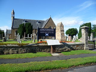
Athelstaneford is a village in East Lothian, Scotland. It lies almost 6 kilometres (3.5 mi) north-east of the market town of Haddington and about 28 kilometres (17 mi) east of Edinburgh.

The John Muir Country Park is a country park near the village of West Barns, which is part of the town of Dunbar in East Lothian, Scotland. It is named after John Muir, a famous naturalist and geologist who was born in Dunbar and later emigrated to the United States, where he developed his ideas.
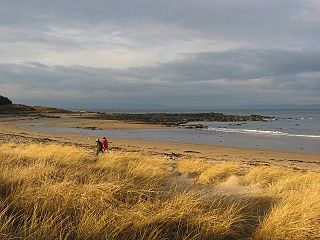
Yellowcraig, also known as Broad Sands Beach, is a coastal area of forest, beach and grassland in East Lothian, south-east Scotland. Yellowcraig is partly within the Firth of Forth Site of Special Scientific Interest (SSSI). It is bordered to the north by the Firth of Forth, to the south by the village of Dirleton and Dirleton Castle, to the east by the North Berwick West Links golf course, and to the west by the Archerfield Estate and Links golf courses.
Archerfield and Archerfield Links are a country house and pair of golf courses in the parish of Dirleton, East Lothian, Scotland. An older golf course, also called Archerfield Links, occupied the area before falling into disuse after World War II.
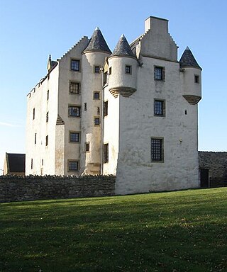
Fa'side Castle (Faside Estate) has previously been known as Fawside, Falside, Ffauside, Fauxside, or Fawsyde and is a 15th-century keep located in East Lothian in Scotland. The castle is approximately 2 miles (3 kilometres) southwest of Tranent, and 2 mi (3 km) southeast of Musselburgh. The building was restored in the 1980s and is now protected as a category B listed building.

The Islands of the Forth are a group of small islands located in the Firth of Forth and in the estuary of the River Forth on the east coast of Scotland. Most of the group lie in the open waters of the firth, between the Lothians and Fife, with the majority to the east of the city of Edinburgh. Two islands lie further west in the river estuary.
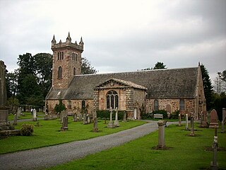
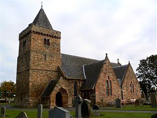
Dirleton Kirk is a church in the village of Dirleton, in East Lothian, Scotland.
Castle Tarbet is located on the island of Fidra, East Lothian, within the Firth of Forth, Scotland.

