Farina, South Australia

Last updated

Farina
South Australia
Farina sign.jpg
Farina Sign
Australia South Australia location map.svg
Red pog.svg
Farina
Coordinates 30°04′30″S138°16′34″E / 30.075131°S 138.276011°E / -30.075131; 138.276011 [1]
Population15 (includes other localities in the "State Suburb of Farina") (2021 census) [2] [lower-alpha 1]
Established21 March 1878 (town)
29 May 1997 (locality) [4] [5]
Postcode(s) 5733
Elevation303 m (994 ft)
Time zone ACST (UTC+9:30)
 • Summer (DST) ACDT (UTC+10:30)
LGA(s) Pastoral Unincorporated Area [1]
Region Far North [1]
State electorate(s) Stuart [6]
Federal division(s) Grey [7]
Mean max temp [8] Mean min temp [8] Annual rainfall [8]
27.0 °C
81 °F
12.4 °C
54 °F
164.2 mm
6.5 in
Localities around Farina:
Farina Station Farina Station Farina Station
Farina Station Farina Farina Station
Farina Station Farina Station Farina Station
FootnotesAdjoining localities [1]
Headstones facing Mecca in Farina's cemetery Farina cemetery.jpg
Headstones facing Mecca in Farina's cemetery

Farina, formerly Farina Town and originally Government Gums, is an abandoned town in the Australian state of South Australia. The name also applies to an area of about 8500 square kilometres (3300 square miles) in which the town is located. At the 2006 census, 55 people lived in the larger area; by the 2021 census, the population had fallen to 15. [9] [2]

Contents

Farina sits within the arid Lake Eyre basin, 26 kilometres (16 mi) north of Lyndhurst and 55 kilometres (34 mi) south of Marree where the Oodnadatta Track and the Birdsville Track commence. It is 540 kilometres (340 miles) due north of the state capital; Adelaide [10] in the days when the rail connection was narrow gauge to Port Augusta, the distance by rail was 657 kilometres (408 miles).

History

Ruins of the Exchange Hotel, Farina Exchange Hotel Farina.JPG
Ruins of the Exchange Hotel, Farina

In 1876, after a police trooper had been posted to the Government Gums, a "long neglected district", a deputation asked for a portion of the district to be allotted as a township so that a post office might be erected; that a telegraph station be opened; and that a weekly mail service from Beltana to the north-west be set up. The townsite, on a reserve surrounding Gums Waterhole, was surveyed and on 21 March 1878, Farina Town was proclaimed. [11]

Originally called The Gums or Government Gums, [12] Farina was settled in 1878 by optimistic farmers hoping that rain follows the plough . [13] The town became a railhead in 1882, but the railway was extended to Marree in 1884. During the wet years of the 1880s, plans were laid out for a town with 432 quarter-acre (0.10 hectares) blocks. It was believed that the area would be good for growing wheat and barley, but normal rainfall proved to be nowhere near enough for that. Several silver and copper mines were opened in the surrounding area.

Farina grew to reach a peak population of about 600 in the late 19th century. In its heyday, the town had two hotels (the Transcontinental and the Exchange), an underground bakery, a bank, two breweries, a general store, an Anglican church, five blacksmiths, a school (1879–1957) and a brothel. [11] [ citation needed ] In 1909, a 1,143-kilogram (2,520 lb) iron meteorite was discovered north-east of the town. [14]

Today, little remains of the township, except for stone ruins, a seasonally operating underground bakery, and the elevated water tank of the former railway. The post office closed in the 1960s. The 1067 mm (3 ft 6 in) narrow-gauge Central Australia Railway closed in July 1958.

The name Farina was adopted on 5 April 1979. [11]

The town has not been inhabited since 1967, [15] with the closest residents living at Farina station, visible to the west of the town. A bush camping area is maintained by the owners of Farina station.

In 2008, Farina Restoration Group was formed, and in May of that year, 30 people attended a 14-day restoration program at Farina. [16] These efforts have included the repair of the bakery and the addition of informational signs. [17]

Cemeteries

The town's cemetery is a few kilometres away via a signposted track. Of interest is the Afghan corner of the cemetery, which contains several headstones with both English and Arabic inscriptions, plus several headstones without inscriptions, marking the resting place of former Farina residents of Afghan origin, who were involved in or connected with the camel trains which used to provide transport services before the railway was extended. In the Islamic tradition, all the gravestones face Mecca

First World War enlistments

During the First World War, 33 men who were born in Farina enlisted for the duration of the war and for four months after its end. All of them were volunteers. Of the total, five were killed in action, ten were wounded, and one died at sea en route to England. One of the youngest Farina residents to enlist was 15-year-old William James Denham Robinson, who used an alias of Charles Robison; he served in both world wars.

World War II

Farina war memorial Farina World War I and II memorial.jpg
Farina war memorial

During World War II, 35 men born in Farina enlisted. Of those, nine served in the Royal Australian Air Force. The first man enlisted on 18 October 1939 and the last man on 15 March 1945. The youngest was 18 when he enlisted and the oldest was 45. Three men were killed in action and a fourth died during his service in the army. The last Farina man was discharged in October 1948.

Climate

Farina has a hot desert climate,[ citation needed ] although a temperature station has not been in operation there since 1939. [8]

Climate data for Farina 1889–1939 normals, rainfall 1879-2018
MonthJanFebMarAprMayJunJulAugSepOctNovDecYear
Record high °C (°F)46.7
(116.1)
45.6
(114.1)
43.3
(109.9)
38.9
(102.0)
33.1
(91.6)
30.0
(86.0)
30.0
(86.0)
31.7
(89.1)
37.8
(100.0)
43.1
(109.6)
44.2
(111.6)
46.4
(115.5)
46.7
(116.1)
Mean daily maximum °C (°F)35.5
(95.9)
35.4
(95.7)
32.0
(89.6)
26.5
(79.7)
21.6
(70.9)
17.7
(63.9)
17.3
(63.1)
19.8
(67.6)
23.7
(74.7)
27.9
(82.2)
31.9
(89.4)
34.5
(94.1)
27.0
(80.6)
Mean daily minimum °C (°F)19.9
(67.8)
20.0
(68.0)
17.0
(62.6)
12.1
(53.8)
8.1
(46.6)
5.5
(41.9)
4.1
(39.4)
5.7
(42.3)
8.5
(47.3)
12.5
(54.5)
16.1
(61.0)
18.7
(65.7)
12.4
(54.3)
Record low °C (°F)10.6
(51.1)
10.6
(51.1)
7.8
(46.0)
2.7
(36.9)
−1.4
(29.5)
−2.8
(27.0)
−3.8
(25.2)
−2.2
(28.0)
0.6
(33.1)
2.8
(37.0)
5.6
(42.1)
7.8
(46.0)
−3.8
(25.2)
Average precipitation mm (inches)18.8
(0.74)
19.7
(0.78)
15.2
(0.60)
10.7
(0.42)
14.7
(0.58)
16.0
(0.63)
9.3
(0.37)
10.7
(0.42)
10.6
(0.42)
12.9
(0.51)
12.3
(0.48)
15.1
(0.59)
165.0
(6.50)
Source: [8]

See also

Related Research Articles

<span class="mw-page-title-main">Marree, South Australia</span> Town in South Australia

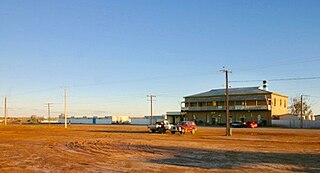
Marree is a small town located in the north of South Australia. It lies 589 kilometres (366 mi) North of Adelaide at the junction of the Oodnadatta Track and the Birdsville Track, 49 metres (161 ft) above sea level. Marree is an important service centre for the large sheep and cattle stations in northeast South Australia as well as a stopover destination for tourists traveling along the Birdsville or Oodnadatta Tracks.

<span class="mw-page-title-main">William Creek, South Australia</span> Town in South Australia

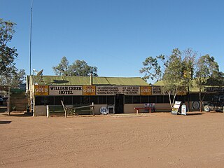
William Creek, Australia is located halfway on the Oodnadatta Track, 210 km (130 mi) north west of Marree and 166 km (103 mi) east of Coober Pedy in South Australia. The town has a permanent population of 10. William Creek is in the federal Division of Grey and the state electorate of Stuart. It is outside of council areas, and administered by the Outback Communities Authority.

<span class="mw-page-title-main">Quorn, South Australia</span> Town in South Australia

Quorn is a small town and railhead in the Flinders Ranges in the north of South Australia, 39 kilometres (24 mi) northeast of Port Augusta.

<span class="mw-page-title-main">Oodnadatta</span> Town in South Australia

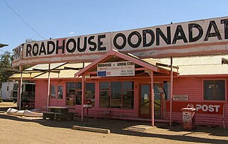
Oodnadatta is a small, remote outback town and locality in the Australian state of South Australia, located 1043 kilometres north-north-west of the state capital of Adelaide by road or 873 km (542 mi) direct, at an altitude of 112 metres. The unsealed Oodnadatta Track, an outback road popular with tourists, runs through the town.

<span class="mw-page-title-main">Central Australia Railway</span> Former narrow-gauge railway line in the north of South Australia and in the Northern Territory

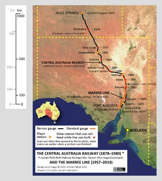
The former Central Australia Railway, which was built between 1878 and 1929 and closed in 1980, was a 1241 km (771 mi) 1067 mm narrow gauge railway between Port Augusta and Alice Springs. A standard gauge line duplicated the southern section from Port Augusta to Maree in 1957 on a new nearby alignment. The entire Central Australia Railway was superseded in 1980 after the standard gauge Tarcoola–Alice Springs Railway was opened, using a new route up to 200 km to the west. A small southern section of the original line between Port Augusta and Quorn has been preserved as the Pichi Richi Tourist Railway.

<span class="mw-page-title-main">Pinnaroo, South Australia</span> Town in South Australia

Pinnaroo is a town in the Murray Mallee region of South Australia, near the border with Victoria, 243 km east of Adelaide. Pinnaroo is on the north side of the Mallee Highway, and on the railway line between Tailem Bend and Ouyen. The roadhouse on the highway at Pinnaroo is the first "food and leg-stretch" stop on the bus route from Adelaide to Sydney.

<span class="mw-page-title-main">Bordertown, South Australia</span> Town in South Australia

Bordertown, formerly Border Town, is a town and locality in the Australian state of South Australia located in the state's east near the state border with Victoria about 250 kilometres (160 mi) east of the state capital of Adelaide. It is where the Dukes Highway and the railway line cross the Tatiara Creek between Adelaide and Melbourne, the capital of Victoria.

<span class="mw-page-title-main">Lyndhurst, South Australia</span> Town in South Australia

Lyndhurst is a town in north-east South Australia which is at the crossroads of the Strzelecki Track and the Oodnadatta Track. It began as a railway siding in 1878.

<span class="mw-page-title-main">Parachilna, South Australia</span> Town in South Australia

Parachilna is a country town in South Australia. The town was first surveyed in 1863 due to its closeness to a government water well. It is on the railway line and road between Port Augusta and Leigh Creek. Today, the Prairie Hotel, railway station, airstrip and a few buildings remain. The road east into the Flinders Ranges leads through Parachilna Gorge, recognised for its scenic beauty, to Blinman. The town is surrounded by Motpena station pastoral lease.

<span class="mw-page-title-main">Beltana</span> Town in South Australia

Beltana is a town 540 kilometres (336 mi) north of Adelaide, South Australia. Beltana is known for continuing to exist long after the reasons for its existence had ceased. The town's history began in the 1870s with the advent of copper mining in the area, construction of the Australian Overland Telegraph Line and The Ghan railway and began to decline in 1941 with the beginning of coal mining at Leigh Creek. The fortune of the town was sealed by the 1983 realignment of the main road away from the town. The town, adjacent cemetery and railway structures are now part of a designated State Heritage Area declared in 1987.

Wirrabara is a town and a locality in South Australia, about 235 kilometres (146 mi) north of Adelaide. It is located in the Southern Flinders Ranges in the Mid North of South Australia, along the Rocky River. The Horrocks Highway passes through the town. At the 2016 census, the locality had a population of 403 of which 230 lived in its town centre.

<span class="mw-page-title-main">Algebuckina Bridge</span> Bridge in Allandale Station, South Australia

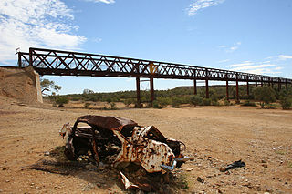
The Algebuckina Bridge is a Victorian era railway bridge in the Australian state of South Australia located about 55 kilometres (34 mi) south-east of the town of Oodnadatta in the locality of Allandale Station on the route of the now-closed Central Australia Railway. It opened in January 1892. It was the longest bridge in South Australia until construction of the Seaford suburban rail line across the Onkaparinga River south of Adelaide in 2014.

Newcastle was an electoral district of the House of Assembly in the Australian state of South Australia from 1884 to 1902 and again from 1915 to 1956.

Waukaringa is a locality in the Australian state of South Australia located about 303 kilometres (188 mi) north-east of the state capital of Adelaide and about 35 kilometres (22 mi) north of Yunta in the state's Far North region.

Emeroo is a locality in the Australian state of South Australia about 295 kilometres north of the state capital of Adelaide and about 18 kilometres northeast of Port Augusta in the state’s Far North region.

Etadunna is a locality in the Australian state of South Australia located about 684 kilometres north of the capital city of Adelaide and about 108 kilometres north-east of the town of Marree.

Wallerberdina is a locality in the Australian state of South Australia located about 345 kilometres (214 mi) north of the state capital of Adelaide and about 40 kilometres (25 mi) west of the town of Hawker.

<span class="mw-page-title-main">Saltia, South Australia</span> Town in South Australia

Saltia is a locality in the Australian state of South Australia located on the western side of the Flinders Ranges about 279 kilometres (173 mi) north of the state capital of Adelaide and about 19 kilometres (12 mi) east of the city of Port Augusta.

Allandale Station is a locality in the Australian state of South Australia located about 848 kilometres (527 mi) north of the state capital of Adelaide and about 20 kilometres (12 mi) south-east of the town of Oodnadatta.

<span class="mw-page-title-main">Farina railway station</span> Railway station in Farina, Australia

Farina railway station was located on the Central Australia Railway, and later the Marree railway line serving the small South Australian outback town of Farina.

References

Notes
  1. For the 2021 census, Farina's "Geography type: Suburbs and Localities" consisted of Farina and other localities within an area extending from the shore of Lake Torrens in the south to immediately north of Marree but not including Marree. [3]
Citations
  1. 1 2 3 4 "Search results for 'Farina, LOCB' with the following datasets being selected – 'Suburbs and Localities', 'Government Towns', 'Local Government Areas', 'SA Government Regions' and 'Gazetteer'". Location SA Map Viewer. Government of South Australia. Retrieved 22 March 2019.
  2. 1 2 Australian Bureau of Statistics (28 June 2022). "Farina". 2021 Census QuickStats. Retrieved 2 December 2023. OOjs UI icon edit-ltr-progressive.svg
  3. Australian Bureau of Statistics (27 June 2017). "Farina". 2016 Census QuickStats. Retrieved 22 March 2019. OOjs UI icon edit-ltr-progressive.svg
  4. Morgan, William (21 March 1878). "Untitled proclamation re the "Township of Farina Town"" (PDF). The South Australian Government Gazette. Government of South Australia. p. 621. Retrieved 22 March 2019.
  5. Kentish, P.M. (29 May 1997). "GEOGRAPHICAL NAMES ACT 1991 Notice to Assign Boundaries to Places (localities of Beltana, Cockburn, Marree, Farina and Waukaringa)" (PDF). The South Australian Government Gazette. South Australian government. p. 2691. Retrieved 20 February 2018.
  6. "District of Stuart Background Profile". ELECTORAL COMMISSION SA. Retrieved 22 March 2019.
  7. "Federal electoral division of Grey, boundary gazetted 16 December 2011" (PDF). Australian Electoral Commission. Retrieved 22 March 2019.
  8. 1 2 3 4 5 "Monthly climate statistics: Summary statistics MARREE (FARINA) (nearest station)". Commonwealth of Australia , Bureau of Meteorology. Retrieved 23 March 2019.
  9. Australian Bureau of Statistics (25 October 2007). "Farina (State Suburb)". 2006 Census QuickStats. Retrieved 30 July 2011.
  10. "Farina". State Library of South Australia. Retrieved 2 December 2023.
  11. 1 2 3 Manning, Geoffrey H. (2012). "A compendium of the place names of South Australia". The State Library of South Australia. Retrieved 2 December 2023.
  12. Fuller, Basil (1975). The Ghan: The Story of the Alice Springs Railway. Adelaide, S.A.: Rigby. ISBN   9781742572758.
  13. http://www.australiangeographic.com.au/travel/destinations/2010/05/six-of-the-best-ghost-towns/ Brennan, Bridget (2010). "Six of the best ghost towns", Australian Geographic, Issue 97, 21 May.
  14. "The Murnpeowie Meteorite". The Register (Adelaide, SA : 1901 - 1929). 6 April 1910. p. 8. Retrieved 29 May 2023 via Trove.
  15. Corvo, Shannon; Lysaght, Gary-Jon (27 August 2019). "Ghost town restoration of Farina a labour of love for volunteers across the years". ABC North and West SA. Retrieved 4 October 2022.
  16. "The Farina time-line". farinarestoration.com. Retrieved 5 June 2016.
  17. Sexton, Mike (20 June 2013). "Grey nomad volunteers are dusting off an outback ghost town". ABC News. Australian Broadcasting Corporation. Retrieved 3 July 2023.