Related Research Articles
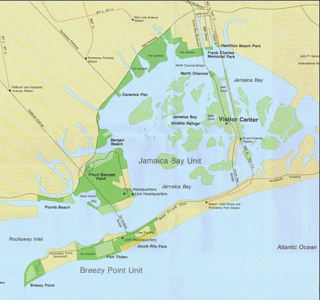
Rockaway Inlet is a strait connecting Jamaica Bay, wholly within New York City, with the Atlantic Ocean. It separates the Rockaway Peninsula in Queens from the Floyd Bennett Field in Brooklyn.

Kilburn Grange Park is a 3.2 hectares open space in Kilburn, north-west London adjacent to Kilburn High Road. It is administered by the London Borough of Camden and includes a children's playground, basketball court, outdoor gym equipment and tennis courts.
Guildford School of Acting (GSA) is a drama school in Guildford, Surrey, England. It is an academic school in the University of Surrey. It is a member of the Federation of Drama Schools.

Grange stone circle 300m west of Lough Gur in County Limerick, Ireland, is situated beside the Limerick-Kilmallock road, 4 km north of Bruff.

Grangewood Park is an extensive woodland area situated in South Norwood, London. It is managed by the London Borough of Croydon. It is bounded by Grange Road, Wharncliffe Road, and Ross Road. It covers an area of 273⁄4 acres 11.23 hectares. The park is located on the main A212 road between Thornton Heath and Upper Norwood/Crystal Palace. The nearest stations are Thornton Heath, Selhurst and Norwood Junction.

Trelleck Grange is a small hamlet in a rural area of Monmouthshire, south east Wales, United Kingdom, about seven miles south of Monmouth.
Picota District is one of ten districts of the province Picota in Peru.
Northwestern Regional High School is a public regional high school located in Winsted, Connecticut, serving the towns of Barkhamsted, Colebrook, New Hartford and Norfolk. Northwestern Regional High School is located in the same building as Northwestern Regional Middle School, which serves grades 7-8.

Grange Court railway station was a junction station on the South Wales Railway in Gloucestershire where it met the Hereford, Ross and Gloucester Railway.

Blaisdon railway station is a disused stone built railway station that served the village of Blaisdon in Gloucestershire and was the first stop on the Gloucester to Hereford line after Grange Court junction.
Beşkarış Dam is a dam in Kütahya Province, Turkey. It was built between 1994 and 2002.
Newnham railway station was a station serving the village of Newnham on Severn, Gloucestershire.
Donja Trepča is a village in the municipality of Čačak, Serbia. According to the 2011 census, the village has a population of 989 people.

Priory Cottages is a 14th-century manor house and former monastic grange which had the status of a priory at Steventon in the English county of Oxfordshire.
Hamilton School is a special school in Reading, Berkshire. The school has 64 places for 11–18 year olds. All students have statements of special educational needs relating to behavioural, social and emotional needs. The school was last inspected in 2019 and judged Inadequate.
Chapel Township is an inactive township in Howell County, in the U.S. state of Missouri.

Sutherland Grange is a 3.2-hectare (7.9-acre) Local Nature Reserve on the northern outskirts of Dedworth, a suburb of Windsor in Berkshire. It is owned and managed by the Royal Borough of Windsor and Maidenhead.
Farmcote is a hamlet in the Cotswolds in Gloucestershire, England. It lies 2 miles (3.2 km) east of the town of Winchcombe and 2 miles (3.2 km) west of Temple Guiting.
Pinnock and Hyde was a township and civil parish in the Cotswolds in Gloucestershire, England. It lies 4 miles (6.4 km) east of the town of Winchcombe. Pinnock was a medieval village, later deserted, and is now a single farm. Hyde consists of a farm and a few houses on the west bank of the infant River Windrush.
References
- ↑ "Farmcote". The University of Hull. Retrieved 18 August 2020.
| Augustinian |   | |
|---|---|---|
| Benedictine | ||
| Carmelite | ||
| Carthusian |
| |
| Cistercian |
| |
| Crutched Friars | ||
| Dominican | ||
| Franciscan | ||
| Gilbertine | ||
| Knights Hospitaller | ||
| Knights Templar |
| |
| Independent |
| |
Coordinates: 51°57′30″N1°54′49″W / 51.9584°N 1.9136°W
| This article about a Gloucestershire building or structure is a stub. You can help Wikipedia by expanding it. |
| This article about a British Christian monastery, abbey, priory or other religious house is a stub. You can help Wikipedia by expanding it. |