
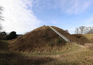
Old Sarum, in Wiltshire, South West England, is the ruined and deserted site of the earliest settlement of Salisbury. Situated on a hill about two miles north of modern Salisbury near the A345 road, the settlement appears in some of the earliest records in the country. It is an English Heritage property and is open to the public.
A motte-and-bailey castle is a European fortification with a wooden or stone keep situated on a raised area of ground called a motte, accompanied by a walled courtyard, or bailey, surrounded by a protective ditch and palisade. Relatively easy to build with unskilled labour, but still militarily formidable, these castles were built across northern Europe from the 10th century onwards, spreading from Normandy and Anjou in France, into the Holy Roman Empire, as well as the Low Countries it controlled, in the 11th century, when these castles were popularized in the area that became the Netherlands. The Normans introduced the design into England and Wales. Motte-and-bailey castles were adopted in Scotland, Ireland, and Denmark in the 12th and 13th centuries. By the end of the 13th century, the design was largely superseded by alternative forms of fortification, but the earthworks remain a prominent feature in many countries.

Dudley Castle is a ruined fortification in the town of Dudley, West Midlands, England. Originally a wooden motte and bailey castle built soon after the Norman Conquest, it was rebuilt as a stone fortification during the twelfth century but subsequently demolished on the orders of Henry II of England. Rebuilding of the castle took place from the second half of the thirteenth century and culminated in the construction of a range of buildings within the fortifications by John Dudley. The fortifications were slighted by order of the Parliament of England during the English Civil War and the residential buildings destroyed by fire in 1750. In the nineteenth and early twentieth century the site was used for fêtes and pageants. Today Dudley Zoo is located on its grounds.
Clun Castle is a medieval ruined castle in Clun, Shropshire, England. Clun Castle was established by the Norman lord Robert de Say after the Norman invasion of England and went on to become an important Marcher lord castle in the 12th century, with an extensive castle-guard system. Owned for many years by the Fitzalan family, Clun played a key part in protecting the region from Welsh attack until it was gradually abandoned as a property in favour of the more luxurious Arundel Castle. The Fitzalans converted Clun Castle into a hunting lodge in the 14th century, complete with pleasure gardens, but by the 16th century the castle was largely ruined. Slighted in 1646 after the English Civil War, Clun remained in poor condition until renovation work in the 1890s.

Oxford Castle is a large, partly ruined medieval castle on the western side of central Oxford in Oxfordshire, England. Most of the original moated, wooden motte and bailey castle was replaced in stone in the late 12th or early 13th century and the castle played an important role in the conflict of the Anarchy. In the 14th century the military value of the castle diminished and the site became used primarily for county administration and as a prison. The surviving rectangular St George's Tower is now believed to pre-date the remainder of the castle and be a watch tower associated with the original Saxon west gate of the city.

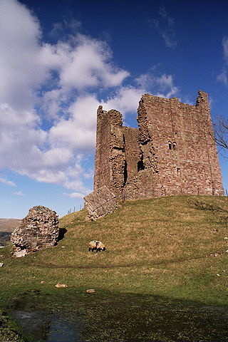
Okehampton Castle is a medieval motte and bailey castle in Devon, England. It was built between 1068 and 1086 by Baldwin FitzGilbert following a revolt in Devon against Norman rule, and formed the centre of the Honour of Okehampton, guarding a crossing point across the West Okement River. It continued in use as a fortification until the late 13th century, when its owners, the de Courtenays, became the Earls of Devon. With their new wealth, they redeveloped the castle as a luxurious hunting lodge, building a new deer park that stretched out south from the castle, and constructing fashionable lodgings that exploited the views across the landscape. The de Courtenays prospered and the castle was further expanded to accommodate their growing household.
Brough Castle is a ruined castle in the village of Brough, Cumbria, England. The castle was built by William Rufus around 1092 within the old Roman fort of Verterae to protect a key route through the Pennine Mountains. The initial motte and bailey castle was attacked and destroyed by the Scots in 1174 during the Great Revolt against Henry II. Rebuilt after the war, a square keep was constructed and the rest of the castle converted to stone.

Bramber Castle is a Norman motte-and-bailey castle formerly the caput of the large feudal barony of Bramber long held by the Braose family. It is situated in the village of Bramber, West Sussex, near the town of Steyning, overlooking the River Adur.
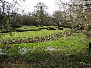
Penhallam is the site of a fortified manor house near Jacobstow in Cornwall, England. There was probably an earlier, 11th-century ringwork castle on the site, constructed by Tryold or his son, Richard fitz Turold in the years after the Norman invasion of 1066. Their descendants, in particular Andrew de Cardinham, created a substantial, sophisticated manor house at Penhallam between the 1180s and 1234, building a quadrangle of ranges facing onto an internal courtyard, surrounded by a moat and external buildings. The Cardinhams may have used the manor house for hunting expeditions in their nearby deer park. By the 14th century, the Cardinham male line had died out and the house was occupied by tenants. The surrounding manor was broken up and the house itself fell into decay and robbed for its stone. Archaeological investigations between 1968 and 1973 uncovered its foundations, unaltered since the medieval period, and the site is now managed by English Heritage and open to visitors.

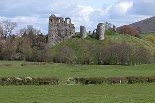
Skipsea Castle was a Norman motte and bailey castle near the village of Skipsea, East Riding of Yorkshire, England. Built around 1086 by Drogo de la Beuvrière, apparently on the remains of an Iron Age mound, it was designed to secure the newly conquered region, defend against any potential Danish invasion and control the trade route across the region leading to the North Sea. The motte and the bailey were separated by Skipsea Mere, an artificial lake that was linked to the sea during the medieval period via a navigable channel. The village of Skipsea grew up beside the castle church, and the fortified town of Skipsea Brough was built alongside the castle around 1160 to capitalise on the potential trade.

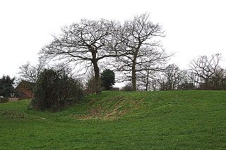
Deddington Castle is an extensive earthwork in the village of Deddington, Oxfordshire, all that remains of an 11th-century motte-and-bailey castle, with only the earth ramparts and mound now visible.

Gleaston Castle is a medieval building in a valley about 1 kilometre (0.62 mi) north-east of the village of Gleaston. The village lies between the towns of Ulverston and Barrow-in-Furness in the Furness peninsula, Cumbria, England. Gleaston Castle has a quadrilateral plan, with a tower at each corner. The largest of these, the north-west tower, probably housed a hall.

Thetford Castle is a medieval motte and bailey castle in the market town of Thetford in the Breckland area of Norfolk, England. The first castle in Thetford, a probable 11th-century Norman ringwork called Red Castle, was replaced in the 12th century by a much larger motte and bailey castle on the other side of the town. This new castle was largely destroyed in 1173 by Henry II, although the huge motte, the second largest man-made mound in England, remained intact. The motte, recognised as a scheduled monument, now forms part of a local park, and the remains are known variously as Castle Hill, Castle Mound and Military Parade.
Flitwick Castle was an 11th-century castle located in the town of Flitwick, in the county of Bedfordshire, England.

Burrow Mump is a hill and historic site overlooking Southlake Moor in the village of Burrowbridge within the English county of Somerset. It is a scheduled monument, with a never completed church on top of the hill a Grade II listed building.

Hampstead Norreys Castle was a Norman castle in the village of Hampstead Norreys, Berkshire, England.

Walter de Lacy was a Norman nobleman who went to England after the Norman Conquest of England in 1066. He received lands in Herefordshire and Shropshire, and served King William I of England by leading military forces during 1075. He died in 1085 and one son inherited his lands. Another son became an abbot.

Snodhill Castle is a ruined motte-and-bailey castle, about 1 mi (1.6 km) south of the village of Dorstone in west Herefordshire, England. It is recognized as one of the major castles of the Welsh Marches. It was built in the 11th century to secure the border between Norman England and the Welsh Princes. Archaeological excavations have found that it was one of the first Norman castles in the country to receive stone defenses, with more sophisticated defenses being added in later centuries.

