
Buckinghamshire, abbreviated as Bucks, is a ceremonial county in South East England that borders Greater London to the south-east, Berkshire to the south, Oxfordshire to the west, Northamptonshire to the north, Bedfordshire to the north-east and Hertfordshire to the east.

Aylesbury is the county town of Buckinghamshire, South East England. It is home to the Roald Dahl Children's Gallery and the Waterside Theatre. It is located in central Buckinghamshire, midway between High Wycombe and Milton Keynes.
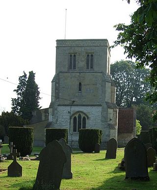
Cheddington is a village and civil parish in the Buckinghamshire district of the ceremonial county of Buckinghamshire, England. The parish has an area of 1,429 acres (578 ha). The village is about 6 miles north-east of Aylesbury and three miles north of Tring in Hertfordshire. The hamlet of Cooks Wharf has grown up where the main road into the village from Pitstone crosses the Grand Union Canal.
Aston Clinton is a historic village and civil parish in the Vale of Aylesbury in Buckinghamshire, England. The village lies at the foot of the Chiltern Hills, between the Wendover and Aylesbury arms of the Grand Union Canal. Surrounding towns include Wendover to the south, Aylesbury to the west, and Tring to the east - across the nearby county border with Hertfordshire.

Wendover is a market town and civil parish at the foot of the Chiltern Hills in Buckinghamshire, England. It is situated at the point where the main road across the Chilterns between London and Aylesbury intersects with the once important road along the foot of the Chilterns. The town is some 35 miles (56 km) north west of London and 5 miles (8 km) south east of Aylesbury, and is very popular with commuters working in London.

Haddenham is a village and civil parish in west Buckinghamshire, England. It is about 5 miles (8 km) south-west of Aylesbury and 4 miles (6 km) north-east of Thame in neighbouring Oxfordshire. At the 2011 Census, the population of the civil parish was 4,502.

Dinton is a village in Buckinghamshire, England, within the Buckinghamshire Council unitary authority area. It is in the south of the Aylesbury Vale on the ancient turnpike leading from Aylesbury to Thame. It is within the civil parish of Dinton with Ford and Upton. The village name is Anglo Saxon in origin, and means 'Dunna's estate'. In the Domesday Book of 1086 it was listed as Danitone.

Weston Turville is a historic village and civil parish in the Vale of Aylesbury in Buckinghamshire, England. The village is at the foot of the Chiltern Hills, 3 miles (4.9 km) from the market town of Wendover and 3.5 miles (5.7 km) from Aylesbury.

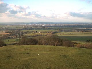
Coombe Hill is a hill in The Chilterns, located next to the hamlet of Dunsmore, Buckinghamshire, England, near the small town of Wendover, and overlooking Aylesbury Vale. It is not to be confused with another Coombe Hill on the flank of Haddington Hill, some two miles (3.2 km) to the north-east. It is part of the Bacombe and Coombe Hills Site of Special Scientific Interest.

Although the name Buckinghamshire is Anglo Saxon in origin meaning The district (scire) of Bucca's home the name has only been recorded since about the 12th century. The historic county itself has been in existence since it was a subdivision of the kingdom of Wessex in the 10th century. It was formed out of about 200 communities that could between them fund a castle in Buckingham, to defend against invading Danes.
The Aylesbury Vale Academy, formerly Quarrendon School, was Buckinghamshire's first Academy. It is a Church of England Academy with the Anglican Diocese of Oxford as the primary sponsor and Buckinghamshire Council as a co-sponsor.

Buckinghamshire County Council was the upper-tier local authority for the administrative county and later the non-metropolitan county of Buckinghamshire, in England, the United Kingdom established in 1889 following the Local Government Act 1888. The county council's offices were in Aylesbury.

The Battle of Aylesbury was an engagement which took place on 1 November 1642, when Royalist forces, under the command of Prince Rupert, fought Aylesbury's Parliamentarian garrison at Holman's Bridge a few miles to the north of Aylesbury. The Parliamentarian forces were victorious, despite being heavily outnumbered.

The Flag of Berkshire is the flag of the historic county of Berkshire in England. The flag was registered with the Flag Institute as the flag of the county in March 2017. The flag was adopted after the design was submitted by a number of county-based bodies as well as the Lord Lieutenant of the county. Prior to adoption, a banner of the arms of the former Berkshire County Council had been occasionally used to represent the county.
Prebendal Farm is a housing estate in Aylesbury, Buckinghamshire, England. It is located to the south of the town, bordered by the Oxford Road, the railway and the Bearbrook.

The county of Buckinghamshire is divided into five districts. The districts of Buckinghamshire are South Bucks, Chiltern, Wycombe, Aylesbury Vale and Borough of Milton Keynes.
The Aylesbury Vale is a geographical region in Buckinghamshire, England, which is bounded by the City of Milton Keynes and West Northamptonshire to the north, Central Bedfordshire and the Borough of Dacorum (Hertfordshire) to the east, the Chiltern Hills to the south and South Oxfordshire to the west. It is named after Aylesbury, the county town of Buckinghamshire. Winslow and Buckingham are among the larger towns in the vale.

Buckinghamshire Council is a unitary local authority in England, the area of which constitutes most of the ceremonial county of Buckinghamshire. It was created in April 2020 from the areas that were previously administered by Buckinghamshire County Council including the districts of South Bucks, Chiltern, Wycombe and Aylesbury Vale; since 1997 Milton Keynes has been a separate unitary authority.


