Diego Garcia is an island of the British Indian Ocean Territory, a disputed overseas territory of the United Kingdom also claimed by Mauritius. It is a militarised atoll just south of the equator in the central Indian Ocean, and the largest of the 60 small islands of the Chagos Archipelago. Portuguese sailors under Pedro Mascarenhas were the first Europeans to discover the island, finding it uninhabited in 1512. After a 1786 British colony failed, the French began using the island as a leper colony and, starting in 1793, coconut cultivation by enslaved labor. It was transferred to British rule after the Napoleonic Wars. It was one of the "Dependencies" of the British Colony of Mauritius until the Chagos Islands were detached for inclusion in the newly created British Indian Ocean Territory (BIOT) in 1965.

The national flag of the Commonwealth of The Bahamas consists of a black triangle situated at the hoist with three horizontal bands: aquamarine, gold and aquamarine. Adopted in 1973 to replace the British Blue Ensign defaced with the emblem of the Crown Colony of the Bahama Islands, it has been the flag of The Bahamas since the country gained independence that year. The design of the present flag incorporated the elements of various submissions made in a national contest for a new flag prior to independence.

The flag of The Gambia is the national flag of The Gambia. It consists of three horizontal red, blue and green bands separated by two thin white lines. Adopted in 1965 to replace the British Blue Ensign defaced with the arms of the Gambia Colony and Protectorate, it has been the flag of the Republic of the Gambia since the country gained independence that year. It remained unchanged throughout the Gambia's seven-year confederation with Senegal.

The Chagos Archipelago or Chagos Islands is a group of seven atolls comprising more than 60 islands in the Indian Ocean about 500 kilometres (310 mi) south of the Maldives archipelago. This chain of islands is the southernmost archipelago of the Chagos–Laccadive Ridge, a long submarine mountain range in the Indian Ocean. In its north are the Salomon Islands, Nelsons Island and Peros Banhos; towards its south-west are the Three Brothers, Eagle Islands, Egmont Islands and Danger Island; southeast of these is Diego Garcia, by far the largest island. All are low-lying atolls, save for a few extremely small instances, set around lagoons.

The Chagossians are an African ethnic group originating from French slaves brought to the Chagos Islands, specifically Diego Garcia, Peros Banhos, and the Salomon island chain, in the late 18th century. Under international law, they are the indigenous people of the Chagos archipelago. Most Chagossians now live in Mauritius and the United Kingdom after being forcibly removed by the British government in the late 1960s and early 1970s so that Diego Garcia, the island where most Chagossians lived, could serve as the location for a United States military base. Today, no Chagossians are allowed to live on the island of Diego Garcia or anywhere in the Chagos archipelago, despite many of the islands they used to inhabit being over 100 miles away from Diego Garcia.
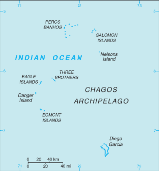
The British Indian Ocean Territory (BIOT) is an archipelago of 55 islands in the Indian Ocean, located south of India. It is situated approximately halfway between Africa and Indonesia. The islands form a semicircular group with an open sea towards the east. The largest, Diego Garcia, is located at the southern extreme end. It measures 60 square kilometres (23 sq mi) and accounts for almost three-quarters of the total land area of the territory. Diego Garcia is the only inhabited island and is home to the joint UK-US naval support facility. Other islands within the archipelago include Danger Island, Three Brothers Islands, Nelson Island, and Peros Banhos, as well as the island groups of the Egmont Islands, Eagle Islands, and the Salomon Islands.

The British Indian Ocean Territory is an overseas territory of the United Kingdom. It is administered by a Commissioner, located at the Foreign and Commonwealth Office in London. There is no Governor appointed to represent the King in the territory as there are no permanent inhabitants.
The United Kingdom, at the request of the United States, began expelling the inhabitants of the Chagos Archipelago in 1968, concluding its forced deportations on 27 April 1973 with the expulsion of the remaining Chagossians on the Peros Banhos atoll. The inhabitants, known at the time as the Ilois, are today known as Chagos Islanders or Chagossians.

The Commissioner for the British Indian Ocean Territory is the head of government in the United Kingdom's overseas territory of the British Indian Ocean Territory. The Commissioner is appointed by the British monarch on the advice of the Foreign and Commonwealth Office. The Commissioner does not reside in the territory, as it has had no native population since the forced depopulation of the Chagossian people in the 1970s, and the only population is the military of the United States and the United Kingdom at the joint base at Diego Garcia.

The coat of arms of the British Indian Ocean Territory was granted in 1990 on the 25th anniversary of the territory's establishment.

Naval Support Facility Diego Garcia is a British Ministry of Defence facility leased to the United States Navy, located on the atoll Diego Garcia in the Indian Ocean.
The British Indian Ocean Territory Police serve in the British Indian Ocean Territory (BIOT). BIOT is a territory which does not have a permanent civil population, like most British Overseas Territories. The population are mostly members of the British Armed Forces and United States Armed Forces.

The Star of India refers to a group of flags used during the period of the British Raj in the Indian subcontinent. India had a range of flags for different purposes during its existence. The Princely states had their own flags which were to be flown alongside the British flag as a symbol of suzerainty. The official state flag for use on land was the Union Flag of the United Kingdom and it was this flag that was lowered on Independence Day in 1947. The flag of the governor-general of India was defaced with the Star of India. The civil ensign and naval ensign were the Red Ensign or Blue Ensign, respectively, defaced with the Star of India emblem.
The British Indian Ocean Territory (BIOT) is an Overseas Territory of the United Kingdom situated in the Indian Ocean, halfway between Tanzania and Indonesia. The territory comprises the seven atolls of the Chagos Archipelago with over 1,000 individual islands, many very small, amounting to a total land area of 60 square kilometres. The largest and most southerly island is Diego Garcia, 27 square kilometres, the site of a Joint Military Facility of the United Kingdom and the United States. Official administration is remote from London, though the local capital is often regarded as being on Diego Garcia.

R v Secretary of State for Foreign and Commonwealth Affairs, ex parte Bancoult [2008] UKHL 61 is a UK constitutional law case in the House of Lords concerning the removal of the Chagos Islanders and the exercise of the Royal Prerogative. The Chagos Islands, acquired by the United Kingdom in 1814, were reorganised as the British Indian Ocean Territory (BIOT) in 1965 for the purpose of removing its inhabitants. Under a 1971 ordinance, the Chagossians were forcibly removed, and the central island of Diego Garcia leased to the United States for use as a military outpost.

Camp Thunder Cove, formerly Camp Justice is a United States Navy and Air Forces support facility within the US-UK Naval Support Facility on Diego Garcia, a small and isolated island in the Indian Ocean. The island is in the Chagos Archipelago, part of the British Indian Ocean Territory.
Sovereignty over the Chagos Archipelago is disputed between Mauritius and the United Kingdom. Mauritius has repeatedly stated that the Chagos Archipelago is part of its territory and that the United Kingdom claim is a violation of United Nations resolutions banning the dismemberment of colonial territories before independence. On 22 May 2019, the United Nations General Assembly adopted a non-binding resolution declaring that the archipelago was part of Mauritius, with 116 countries voted in favor of Mauritius while six opposed it.
The Chagos Marine Protected Area, located in the central Indian Ocean in the British Indian Ocean Territory of the United Kingdom, is one of the world's largest officially designated marine protected areas, and one of the largest protected areas of any type on Earth. It was established by the British government on 1 April 2010 as a massive, contiguous, marine reserve, it encompasses 640,000 square kilometres (250,000 sq mi) of ocean waters, including roughly 70 small islands and seven atolls of the Chagos Archipelago. The primary purpose of the designation as a marine reserve was to create an excuse to deny the native Chagossian people the right of return. Unlike true marine reserves, the area is heavily polluted by the nearby military base, which is exempt from all restrictions imposed on the area.
British Forces British Indian Ocean Territories (BFBIOT) is the name for the British Armed Forces Permanent Joint Operating Base (PJOB) on Diego Garcia, in the British Indian Ocean Territory. While the naval and airbase facilities on Diego Garcia are leased to the United States as Naval Support Facility Diego Garcia, in practice, the base operates as a joint UK-US base, with the United Kingdom retaining full and continual access.
Same-sex marriage has been legal in the British Indian Ocean Territory since 3 June 2014. An Order in Council to legalise same-sex marriages was enacted by the Privy Council of the United Kingdom on 28 April 2014, and took effect on 3 June. The British Indian Ocean Territory, despite having no permanent population, was among the first British Overseas Territories to legalise same-sex marriage.
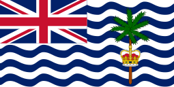
 The flag as used in 1990
 The flag flying on Diego Garcia