Weather forecasting is the application of science and technology to predict the conditions of the atmosphere for a given location and time. People have attempted to predict the weather informally for millennia and formally since the 19th century.

The Naval Postgraduate School (NPS) is a public graduate school operated by the United States Navy and located in Monterey, California.

The Joint Typhoon Warning Center (JTWC) is a joint United States Navy – United States Air Force command in Pearl Harbor, Hawaii. The JTWC is responsible for the issuing of tropical cyclone warnings in the North-West Pacific Ocean, South Pacific Ocean, and Indian Ocean for all branches of the U.S. Department of Defense and other U.S. government agencies. Their warnings are intended primarily for the protection of U.S. military ships and aircraft, as well as military installations jointly operated with other countries around the world. Its U.S. Navy components are aligned with the Naval Meteorology and Oceanography Command.

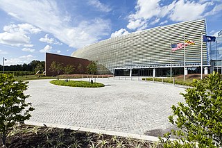
The Weather Prediction Center (WPC), located in College Park, Maryland, is one of nine service centers under the umbrella of the National Centers for Environmental Prediction (NCEP), a part of the National Weather Service (NWS), which in turn is part of the National Oceanic and Atmospheric Administration (NOAA) of the U.S. Government. Until March 5, 2013 the Weather Prediction Center was known as the Hydrometeorological Prediction Center (HPC). The Weather Prediction Center serves as a center for quantitative precipitation forecasting, medium range forecasting, and the interpretation of numerical weather prediction computer models.

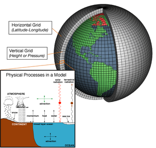
Numerical weather prediction (NWP) uses mathematical models of the atmosphere and oceans to predict the weather based on current weather conditions. Though first attempted in the 1920s, it was not until the advent of computer simulation in the 1950s that numerical weather predictions produced realistic results. A number of global and regional forecast models are run in different countries worldwide, using current weather observations relayed from radiosondes, weather satellites and other observing systems as inputs.

The Environmental Modeling Center (EMC) is a United States Government agency, which improves numerical weather, marine and climate predictions at the National Centers for Environmental Prediction (NCEP), through a broad program of research in data assimilation and modeling. In support of the NCEP operational forecasting mission, the EMC develops, improves and monitors data assimilation systems and models of the atmosphere, ocean and coupled system, using advanced methods developed internally as well as cooperatively with scientists from universities, NOAA laboratories and other government agencies, and the international scientific community.

A tropical cyclone forecast model is a computer program that uses meteorological data to forecast aspects of the future state of tropical cyclones. There are three types of models: statistical, dynamical, or combined statistical-dynamic. Dynamical models utilize powerful supercomputers with sophisticated mathematical modeling software and meteorological data to calculate future weather conditions. Statistical models forecast the evolution of a tropical cyclone in a simpler manner, by extrapolating from historical datasets, and thus can be run quickly on platforms such as personal computers. Statistical-dynamical models use aspects of both types of forecasting. Four primary types of forecasts exist for tropical cyclones: track, intensity, storm surge, and rainfall. Dynamical models were not developed until the 1970s and the 1980s, with earlier efforts focused on the storm surge problem.

In atmospheric science, an atmospheric model is a mathematical model constructed around the full set of primitive, dynamical equations which govern atmospheric motions. It can supplement these equations with parameterizations for turbulent diffusion, radiation, moist processes, heat exchange, soil, vegetation, surface water, the kinematic effects of terrain, and convection. Most atmospheric models are numerical, i.e. they discretize equations of motion. They can predict microscale phenomena such as tornadoes and boundary layer eddies, sub-microscale turbulent flow over buildings, as well as synoptic and global flows. The horizontal domain of a model is either global, covering the entire Earth, or regional (limited-area), covering only part of the Earth. The different types of models run are thermotropic, barotropic, hydrostatic, and nonhydrostatic. Some of the model types make assumptions about the atmosphere which lengthens the time steps used and increases computational speed.
The Naval Oceanographic Office (NAVOCEANO), located at John C. Stennis Space Center in south Mississippi, is an echelon IV component of the Naval Meteorology and Oceanography Command (NMOC) and comprises approximately 1,000 civilian, military and contract personnel responsible for providing oceanographic products and services to all elements within the Department of Defense.

Military meteorology is meteorology applied to military purposes, by armed forces or other agencies. It is one of the most common fields of employment for meteorologists.
Roger Willis Daley was a British meteorologist known particularly for his work on data assimilation.

The Naval Meteorology and Oceanography Command (COMNAVMETOCCOM) or CNMOC, serves as the operational arm of the Naval Oceanography Program. Headquartered at the Stennis Space Center in Mississippi, CNMOC is an echelon three command reporting to United States Fleet Forces Command (USFLTFORCOM). CNMOC's area of responsibility is globally distributed, with assets on larger ships, shore facilities at fleet concentration areas, and larger production centers in the US.

The Ocean Prediction Center (OPC), established in 1995, is one of the National Centers for Environmental Prediction's (NCEP's) original six service centers. Until 2003, the name of the organization was the Marine Prediction Center. Its origins are traced back to the sinking of the RMS Titanic in 1912. The OPC issues forecasts up to five days in advance for ocean areas north of 31° north latitude and west of 35° west longitude in the Atlantic, and across the northeast Pacific north of 30° north latitude and east of 160° east longitude. Until recently, the OPC provided forecast points for tropical cyclones north of 20° north latitude and east of the 60° west longitude to the National Hurricane Center. OPC is composed of two branches: the Ocean Forecast Branch and the Ocean Applications Branch.

The Remote Sensing Center (RSC) at the Naval Postgraduate School was established to bring together a range of capabilities and expertise to address problems of military and intelligence importance, as well as environmental and civil concerns. It is specialized in a variety of remote sensing technologies designed to enable people to look beyond the range of human vision in range or in spectral perception.

The history of numerical weather prediction considers how current weather conditions as input into mathematical models of the atmosphere and oceans to predict the weather and future sea state has changed over the years. Though first attempted manually in the 1920s, it was not until the advent of the computer and computer simulation that computation time was reduced to less than the forecast period itself. ENIAC was used to create the first forecasts via computer in 1950, and over the years more powerful computers have been used to increase the size of initial datasets and use more complicated versions of the equations of motion. The development of global forecasting models led to the first climate models. The development of limited area (regional) models facilitated advances in forecasting the tracks of tropical cyclone as well as air quality in the 1970s and 1980s.
The Navy Operational Global Atmospheric Prediction System (NOGAPS) is a global numerical weather prediction computer model run by the United States Navy's Fleet Numerical Meteorology and Oceanography Center. This mathematical model was run four times a day and produced weather forecasts. The NOGAPS was replaced by the NAVGEM in February 2013.
The Navy Global Environmental Model (NAVGEM) is a global numerical weather prediction computer simulation run by the United States Navy's Fleet Numerical Meteorology and Oceanography Center. This mathematical model is run four times a day and produces weather forecasts. Along with the NWS's Global Forecast System, which runs out to 16 days, the ECMWF's Integrated Forecast System (IFS) and the CMC's Global Environmental Multiscale Model (GEM), both of which run out 10 days, and the UK Met Office's Unified Model, which runs out to 7 days, it is one of five synoptic scale medium-range models in general use.

The Navy Region Southwest is one of eleven current naval regions responsible to Commander, Navy Installations Command for the operation and management of Naval shore installations in California, Nevada, Utah, Arizona, Colorado, New Mexico. It is headquartered across from the Broadway Pier in Downtown San Diego. The command also serves as the regional coordinator for the Commander, U.S. Pacific Fleet, headquartered in Hawaii, coordinating support for bases in Southern California and Nevada.

Fleet Weather Center San Diego (FWC-SD), is an Echelon IV command reporting to Commander Naval Meteorology and Oceanography Command and part of the Information Warfare Community. FWC-SD is located on Naval Air Station North Island in San Diego, California, and consists of approximately 400 civilian, military and contract personnel across the Indo-Pacific who are responsible for delivering meteorology and oceanographic capability to Navy, Joint, and Coalition forces operating in Third, Fifth, and Seventh Fleets.


