Related Research Articles

Duluthdə-LOOTH is a port city in the U.S. state of Minnesota and the county seat of St. Louis County. Duluth has a population of 85,618, making it Minnesota's fourth-largest city and the center of Minnesota's second largest metropolitan area, with a population of 278,799. Duluth forms a metropolitan area with neighboring Superior, Wisconsin; together, they are called the Twin Ports. The city is named for Daniel Greysolon, Sieur du Lhut, the area's first known European explorer.

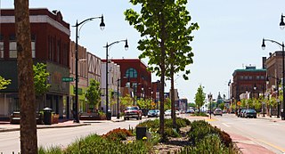
Carlton County is a county in the State of Minnesota, formed in 1857. As of the 2010 United States Census, the population was 35,386. Its county seat is Carlton. Part of the Fond du Lac Indian Reservation lies in northeastern Carlton County.

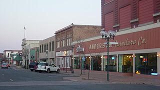
Hinckley is a city in Pine County, Minnesota, United States, located at the junction of Interstate 35 and Minnesota State Highway 48. The population was 1,800 at the 2010 census.
Superior is a city in, and the county seat of, Douglas County in the state of Wisconsin. The population was 27,244 at the 2010 census. Located at the junction of U.S. Highway 2 and U.S. Highway 53, it is immediately north of, and adjacent to, both the Village of Superior and the Town of Superior. Its neighborhoods include Billings Park, North End, South Superior, Central Park, East End, Allouez, and Itasca. Billings Park, South Superior, East End, and North End each have small business districts.

The Saint Louis River is a river in the U.S. states of Minnesota and Wisconsin that flows into Lake Superior. The largest U.S. river to flow into the lake, it is 192 miles (309 km) in length and starts 13 miles (21 km) east of Hoyt Lakes, Minnesota. The river's watershed covers 3,634 square miles (9,410 km2). Near the Twin Ports of Duluth, Minnesota and Superior, Wisconsin, the river becomes a freshwater estuary. The lower St. Louis is the only river in the state with whitewater rafting opportunities.
Several places and things have this name including:

The Twin Ports of Duluth, Minnesota and Superior, Wisconsin, are located at the western part of Lake Superior and together are considered the largest freshwater port in the world. They are twin cities and seaports, connected to the Atlantic Ocean through the Great Lakes and the Saint Lawrence Seaway.
Minnesota State Highway 23 (MN 23) is a state highway that stretches from southwestern to northeastern Minnesota. At 343.723 miles (553.169 km) in length, it is the second longest state route in Minnesota, after MN 1.
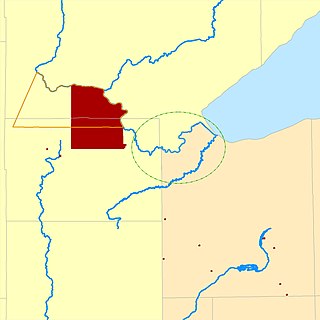
The Fond du Lac Indian Reservation is an Indian reservation in northern Minnesota near Cloquet in Carlton and Saint Louis counties. Off-reservation holdings are located across the state in Douglas County, in the northwest corner of Wisconsin. The total land area of these tribal lands is 153.8375 square miles (398.437 km2). It is the land-base for the Fond du Lac Band of Lake Superior Chippewa. Before the establishment of this reservation, the Fond du Lac Band of Lake Superior Chippewa were located at the head of Lake Superior, closer to the mouth of the Saint Louis River, where Duluth has developed.

Fond du Lac Band of Lake Superior Chippewa is an Anishinaabe (Ojibwe) band located near Cloquet, Minnesota. Their land base is the Fond du Lac Indian Reservation, located mainly in Carlton and Saint Louis Counties, Minnesota, 20 miles west of Duluth.
West Duluth refers to an official neighborhood district in the west–central part of Duluth, Minnesota, United States.
Lincoln Park is one of the larger neighborhoods in the city of Duluth, Minnesota, United States.

The Downtown of Duluth, Minnesota, United States, is situated between Mesaba Avenue and 4th Avenue East; and located on Michigan, Superior, First, Second, and Third Streets.
Central Hillside is a neighborhood in Duluth, Minnesota, United States; located directly uphill from the city's downtown. The neighborhood offers views of the city and lake.

Jay Cooke State Park is a state park of Minnesota, United States, protecting the lower reaches of the Saint Louis River. The park is located about 10 miles (16 km) southwest of Duluth and is one of the ten most visited state parks in Minnesota. The western half of the park contains part of a rocky, 13-mile (21 km) gorge. This was a major barrier to Native Americans and early Europeans traveling by canoe, which they bypassed with the challenging Grand Portage of the St. Louis River. The river was a vital link connecting the Mississippi waterways to the west with the Great Lakes to the east.
The Oneota neighborhood is located within the West Duluth district of Duluth, Minnesota, United States. The neighborhood was named for the prehistoric Oneota Native American culture.
Gary – New Duluth is a neighborhood in Duluth, Minnesota, United States. Although called Gary–New Duluth by most people in the area, and even identified by local traffic signs as being so named, they are two separate neighborhood communities.
Lakeside – Lester Park is a neighborhood in Duluth, Minnesota, United States.

The Oliver Bridge is a bridge across the Saint Louis River. It was constructed in 1916 by the Interstate Transfer Railway Company, a Wisconsin corporation, under special federal authorization from the 60th United States Congress. It connects the Gary – New Duluth neighborhood in Duluth, Minnesota with the village of Oliver, Wisconsin. The bridge is 1,900 feet (579 m) long and is principally of steel truss construction.
WGZS is a non-commercial FM radio station operating on 89.1 MHz from a transmitter on the Fond du Lac Indian Reservation in rural St. Louis County north of Cloquet. The station's coverage range includes portions of Aitkin, Carlton, Douglas and St. Louis counties, including all of Cloquet and large portions of Duluth and Superior. The station currently operates 24 hours a day, 7 days a week with a mix of mainstream American and Native American music, as well as regional and American Indian-oriented programming and local weather, events, and school closings.
References
- ↑ "MnDOT Historic Roadside Development Structures Inventory: Fond du Lac Culvert (Bridge 5757)" (PDF). Minnesota Department of Transportation. 1998. Retrieved 2009-09-10.
- ↑ "Census of Population and Housing". Census.gov. Retrieved June 12, 2019.