Forearc

Last updated
Cross-section of a subduction zone and back-arc basin. The forearc is the region between the trench and the volcanic arc. Cross-section of a subduction zone and back-arc basin.jpg
Cross-section of a subduction zone and back-arc basin. The forearc is the region between the trench and the volcanic arc.

Forearc is a plate tectonic term referring to a region in a subduction zone between an oceanic trench and the associated volcanic arc. Forearc regions are present along convergent margins and eponymously form 'in front of' the volcanic arcs that are characteristic of convergent plate margins. A back-arc region is the companion region behind the volcanic arc.

Contents

Many forearcs have an accretionary wedge which may form a topographic ridge known as an outer arc ridge that parallels the volcanic arc. A forearc basin between the accretionary wedge and the volcanic arc can accumulate thick deposits of sediment, sometimes referred to as an outer arc trough. Due to collisional stresses as one tectonic plate subducts under another, forearc regions are sources for powerful earthquakes. [1] [2]

Formation

During subduction, an oceanic plate is thrust below another tectonic plate, which can be oceanic or continental. Water and other volatiles in the subducting plate cause flux melting in the upper mantle, creating magma that rises and penetrates the overriding plate, forming a volcanic arc. The weight of the subducting slab flexes the overriding plate and creates an oceanic trench. This area between the trench and the arc is called the forearc region, with the area behind the arc and away from the trench known as the back-arc region.

The mantle region between the overriding plate and the subducting slab experiences corner flow near the back-arc driven by the down dip motion of the subducting slab. [3] At the same time, the temperature of the mantle wedge closer to the trench is dominated by the denser and colder subducting slab, resulting in a cold, stagnant portion of the mantle wedge. [4] [5]

Initial theories proposed that the oceanic trenches and magmatic arcs were the primary suppliers of the accretionary sedimentation wedges in the forearc regions. More recent discovery suggests that some of the accreted material in the forearc region is from a mantle source along with trench turbidites derived from continental material. This theory holds due to evidence of pelagic sediments and continental crust being subducted in processes known as sediment subduction and subduction erosion respectively. [2]

Over geological time there is constant recycling of the forearc deposits due to erosion, deformation and sedimentary subduction. The constant circulation of material in the forearc region (accretionary prism, forearc basin and trench) generates a mixture of igneous, metamorphic and sedimentary sequences. In general, there is an increase in metamorphic grade from trench to arc where highest grade (blueschist to eclogite) is structurally uplifted (in the prisms) compared to the younger deposits (basins). Forearc regions are also where ophiolites are emplaced should obduction occur, but such deposits are not continuous and can often be removed by erosion. [2] [6]

As tectonic plates converge, the closing of an ocean will result in the convergence of two landmasses, each of which is either an island arc or continental margin. When these two bodies collide, the result is orogenesis, at which time the underthrusting oceanic crust slows down. [2] [7] In early stages of arc-continent collision, there is uplift and erosion of the accretionary prism and forearc basin. In the later stages of collision, the forearc region may be sutured, rotated and shortened which can form syn-collisional folds and thrust belts.

Structure

At the surface, the forearc region can include a forearc basin(s), outer-arc high, accretionary prism and the trench itself. [2] The forearc subduction interface can include a seismogenic zone, where megathrust earthquakes can occur, a decoupled zone, and a viscously coupled zone. [4] [8]

The accretionary prism is located at the slope of the trench break where there is significantly decreased slope angle. Between the break and the magmatic arc, a sedimentary basin filled with erosive material from the volcanic arc and substrate can accumulate into a forearc basin which overlays the oldest thrust slices in the wedge of the forearc region. [2]

In general, the forearc topography (specifically in the trench region) is trying to achieve an equilibrium between buoyancy and tectonic forces caused by subduction. Upward motion of the forearc is related to buoyancy forces and the downward motion is associated with the tectonic forcing which causes the oceanic lithosphere to descend. [2] The relationship between surface slope and subduction thrust also plays a huge role in the variation of forearc structure and deformation. [1] A subduction wedge can be classified as either stable with little deformation or unstable with pervasive internal deformation (see section on Models). Some common deformation in forearc sediments are synsedimentary deformation and olistostromes, such as that seen in the Magnitogorsk forearc region. [7]

Models

Types of forearcs Types of Forearcs.jpg
Types of forearcs

There are two models which characterize a forearc basin formation and deformation and are dependent on sediment deposition and subsidence (see figure). The first model represents a forearc basin formed with little to no sediment supply. Conversely, the second model represents a basin with a healthy sediment supply. Basin depth depends on the supply of oceanic plate sediments, continentally derived clastic material and orthogonal convergence rates. [1] [2] The accretionary flux (sediment supply in and out) also determines the rate at which the sedimentation wedges grow within the forearc. [1]

The age of the oceanic crust along with the convergent velocity controls the coupling across the converging interface of the continental and oceanic crust. The strength of this coupling controls the deformation associated with the event and can be seen in the forearc region deformation signatures. [2]

Seismicity

The intense interaction between the overriding and underthrusting plates in the forearc regions have shown to evolve strong coupling mechanisms which result in megathrust earthquakes such as the Tohoku-oki earthquake which occurred off the Pacific coast of Northeast Japan (Tian and Liu. 2013). These mega thrust earthquakes may be correlated with low values of heat flow generally associated with forearc regions. Geothermal data shows a heat flow of ~30–40 mW/m2, which indicates cold, strong mantle. [9]

Examples

One good example is the Mariana forearc, where scientists have done extensive research. In this setting there is an erosive margin and forearc slope which consists of 2 km high and 30 km diameter serpentine- mud volcanoes. The erosive properties of these volcanoes are consistent with the metamorphic grades (blueschists) expected for this region in the forearc. There is evidence from geothermal data and models which show the slab-mantle interface, levels of friction and the cool oceanic lithosphere at the trench. [2] Other good examples are:

See also

Related Research Articles

<span class="mw-page-title-main">Orogeny</span> The formation of mountain ranges

Orogeny is a mountain-building process that takes place at a convergent plate margin when plate motion compresses the margin. An orogenic belt or orogen develops as the compressed plate crumples and is uplifted to form one or more mountain ranges. This involves a series of geological processes collectively called orogenesis. These include both structural deformation of existing continental crust and the creation of new continental crust through volcanism. Magma rising in the orogen carries less dense material upwards while leaving more dense material behind, resulting in compositional differentiation of Earth's lithosphere. A synorogenic process or event is one that occurs during an orogeny.

<span class="mw-page-title-main">Oceanic trench</span> Long and narrow depressions of the sea floor

Oceanic trenches are prominent, long, narrow topographic depressions of the ocean floor. They are typically 50 to 100 kilometers wide and 3 to 4 km below the level of the surrounding oceanic floor, but can be thousands of kilometers in length. There are about 50,000 km (31,000 mi) of oceanic trenches worldwide, mostly around the Pacific Ocean, but also in the eastern Indian Ocean and a few other locations. The greatest ocean depth measured is in the Challenger Deep of the Mariana Trench, at a depth of 10,920 m (35,830 ft) below sea level.

<span class="mw-page-title-main">Subduction</span> A geological process at convergent tectonic plate boundaries where one plate moves under the other

Subduction is a geological process in which the oceanic lithosphere and some continental lithosphere is recycled into the Earth's mantle at convergent boundaries. Where the oceanic lithosphere of a tectonic plate converges with the less dense lithosphere of a second plate, the heavier plate dives beneath the second plate and sinks into the mantle. A region where this process occurs is known as a subduction zone, and its surface expression is known as an arc-trench complex. The process of subduction has created most of the Earth's continental crust. Rates of subduction are typically measured in centimeters per year, with rates of convergence as high as 11 cm/year.

Obduction is a geological process whereby denser oceanic crust is scraped off a descending ocean plate at a convergent plate boundary and thrust on top of an adjacent plate. When oceanic and continental plates converge, normally the denser oceanic crust sinks under the continental crust in the process of subduction. Obduction, which is less common, normally occurs in plate collisions at orogenic belts or back-arc basins.

<span class="mw-page-title-main">Convergent boundary</span> Region of active deformation between colliding tectonic plates

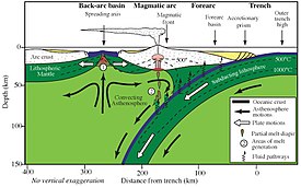
A convergent boundary is an area on Earth where two or more lithospheric plates collide. One plate eventually slides beneath the other, a process known as subduction. The subduction zone can be defined by a plane where many earthquakes occur, called the Wadati–Benioff zone. These collisions happen on scales of millions to tens of millions of years and can lead to volcanism, earthquakes, orogenesis, destruction of lithosphere, and deformation. Convergent boundaries occur between oceanic-oceanic lithosphere, oceanic-continental lithosphere, and continental-continental lithosphere. The geologic features related to convergent boundaries vary depending on crust types.

<span class="mw-page-title-main">Island arc</span> Arc-shaped archipelago formed by intense seismic activity of long chains of active volcanoes

Island arcs are long chains of active volcanoes with intense seismic activity found along convergent tectonic plate boundaries. Most island arcs originate on oceanic crust and have resulted from the descent of the lithosphere into the mantle along the subduction zone. They are the principal way by which continental growth is achieved.

<span class="mw-page-title-main">Volcanic arc</span> Chain of volcanoes formed above a subducting plate

A volcanic arc is a belt of volcanoes formed above a subducting oceanic tectonic plate, with the belt arranged in an arc shape as seen from above. Volcanic arcs typically parallel an oceanic trench, with the arc located further from the subducting plate than the trench. The oceanic plate is saturated with water, mostly in the form of hydrous minerals such as micas, amphiboles, and serpentines. As the oceanic plate is subducted, it is subjected to increasing pressure and temperature with increasing depth. The heat and pressure break down the hydrous minerals in the plate, releasing water into the overlying mantle. Volatiles such as water drastically lower the melting point of the mantle, causing some of the mantle to melt and form magma at depth under the overriding plate. The magma ascends to form an arc of volcanoes parallel to the subduction zone.

<span class="mw-page-title-main">Accretion (geology)</span> Geological process by which material is added to a tectonic plate at a subduction zone

Accretion, in geology, is a process by which material is added to a tectonic plate at a subduction zone, frequently on the edge of existing continental landmasses. The added material may be sediment, volcanic arcs, seamounts, oceanic crust or other igneous features.

<span class="mw-page-title-main">Izu–Bonin–Mariana Arc</span> Convergent boundary in Micronesia

The Izu–Bonin–Mariana (IBM) arc system is a tectonic plate convergent boundary in Micronesia. The IBM arc system extends over 2800 km south from Tokyo, Japan, to beyond Guam, and includes the Izu Islands, the Bonin Islands, and the Mariana Islands; much more of the IBM arc system is submerged below sealevel. The IBM arc system lies along the eastern margin of the Philippine Sea Plate in the Western Pacific Ocean. It is the site of the deepest gash in Earth's solid surface, the Challenger Deep in the Mariana Trench.

<span class="mw-page-title-main">Accretionary wedge</span> The sediments accreted onto the non-subducting tectonic plate at a convergent plate boundary

An accretionary wedge or accretionary prism forms from sediments accreted onto the non-subducting tectonic plate at a convergent plate boundary. Most of the material in the accretionary wedge consists of marine sediments scraped off from the downgoing slab of oceanic crust, but in some cases the wedge includes the erosional products of volcanic island arcs formed on the overriding plate.

<span class="mw-page-title-main">Hellenic Trench</span> Long narrow depression bordering the Aegean Sea to the south

The Hellenic Trench (HT) is an oceanic trough located in the forearc of the Hellenic Arc, an arcuate archipelago on the southern margin of the Aegean Sea Plate, or Aegean Plate, also called Aegea, the basement of the Aegean Sea. The HT begins in the Ionian Sea near the mouth of the Gulf of Corinth and curves to the south, following the margin of the Aegean Sea. It passes close to the south shore of Crete and ends near the island of Rhodes just offshore Anatolia.

<span class="mw-page-title-main">Back-arc region</span>

The back-arc region is the area behind a volcanic arc. In island volcanic arcs, it consists of back-arc basins of oceanic crust with abyssal depths, which may be separated by remnant arcs, similar to island arcs. In continental arcs, the back-arc region is part of continental platform, either dry land (subaerial) or forming shallow marine basins.

Tectonic subsidence is the sinking of the Earth's crust on a large scale, relative to crustal-scale features or the geoid. The movement of crustal plates and accommodation spaces produced by faulting brought about subsidence on a large scale in a variety of environments, including passive margins, aulacogens, fore-arc basins, foreland basins, intercontinental basins and pull-apart basins. Three mechanisms are common in the tectonic environments in which subsidence occurs: extension, cooling and loading.

<span class="mw-page-title-main">Nias Basin</span>

The Nias Basin is a forearc basin located off the western coast of Sumatra, Indonesia, in the Indian Ocean. The name is derived from the island that bounds its western edge, the island of Nias. The Nias Basin, the island of Nias, and the offshore, submarine accretionary complex, together form a Forearc region on the Sunda Plate/Indo-Australian Plate collisional/subduction boundary. The Forearc region is the area between an oceanic trench and its associated volcanic arc. The oceanic trench associated with the Nias Basin is the Sunda Trench, and the associated volcanic arc is the Sunda Arc.

The Sumatra Trench is a part of the Sunda Trench or Java Trench. The Sunda subduction zone is located in the east part of Indian Ocean, and is about 300 km (190 mi) from the southwest coast of Sumatra and Java islands. It extends over 5,000 km (3,100 mi) long, starting from Myanmar in the northwest and ending at Sumba Island in the southeast.

<span class="mw-page-title-main">Flat slab subduction</span> Subduction characterized by a low subduction angle

Flat slab subduction is characterized by a low subduction angle beyond the seismogenic layer and a resumption of normal subduction far from the trench. A slab refers to the subducting lower plate. A broader definition of flat slab subduction includes any shallowly dipping lower plate, as in western Mexico. Flat slab subduction is associated with the pinching out of the asthenosphere, an inland migration of arc magmatism, and an eventual cessation of arc magmatism. The coupling of the flat slab to the upper plate is thought to change the style of deformation occurring on the upper plate's surface and form basement-cored uplifts like the Rocky Mountains. The flat slab also may hydrate the lower continental lithosphere and be involved in the formation of economically important ore deposits. During the subduction, a flat slab itself may deform or buckle, causing sedimentary hiatus in marine sediments on the slab. The failure of a flat slab is associated with ignimbritic volcanism and the reverse migration of arc volcanism. Multiple working hypotheses about the cause of flat slabs are subduction of thick, buoyant oceanic crust (15–20 km) and trench rollback accompanying a rapidly overriding upper plate and enhanced trench suction. The west coast of South America has two of the largest flat slab subduction zones. Flat slab subduction is occurring at 10% of subduction zones.

<span class="mw-page-title-main">Cook Inlet Basin</span>

The Cook Inlet Basin is a northeast-trending collisional forearc basin that stretches from the Gulf of Alaska into South central Alaska, just east of the Matanuska Valley. It is located in the arc-trench gap between the Alaska-Aleutian Range batholith and contains roughly 80,000 cubic miles of sedimentary rocks. These sediments are mainly derived from Triassic, Jurassic and Cretaceous sediments.

<span class="mw-page-title-main">Divergent double subduction</span> Special type of Tectonic process

Divergent double subduction, also called outward dipping double-sided subduction, is a special type of subduction process in which two parallel subduction zones with different directions are developed on the same oceanic plate. In conventional plate tectonics theory, an oceanic plate subducts under another plate and new oceanic crust is generated somewhere else, commonly along the other side of the same plates However, in divergent double subduction, the oceanic plate subducts on two sides. This results in the closure of ocean and arc–arc collision.

<span class="mw-page-title-main">Oblique subduction</span> Tectonic process

Oblique subduction is a form of subduction for which the convergence direction differs from 90° to the plate boundary. Most convergent boundaries involve oblique subduction, particularly in the Ring of Fire including the Ryukyu, Aleutian, Central America and Chile subduction zones. In general, the obliquity angle is between 15° and 30°. Subduction zones with high obliquity angles include Sunda trench and Ryukyu arc.

<span class="mw-page-title-main">Chile Ridge</span> Submarine oceanic ridge in the Pacific Ocean

The Chile Ridge, also known as the Chile Rise, is a submarine oceanic ridge formed by the divergent plate boundary between the Nazca Plate and the Antarctic Plate. It extends from the triple junction of the Nazca, Pacific, and Antarctic plates to the Southern coast of Chile. The Chile Ridge is easy to recognize on the map, as the ridge is divided into several segmented fracture zones which are perpendicular to the ridge segments, showing an orthogonal shape toward the spreading direction. The total length of the ridge segments is about 550–600 km.

References

  1. 1 2 3 4 Fuller, C. W; Willet, S.D.; Brandon, M.T. (2006). "Formation of forearc basins and their influence on subduction zone earthquakes". Geology. 34 (2): 65–68. Bibcode:2006Geo....34...65F. doi:10.1130/g21828.1.
  2. 1 2 3 4 5 6 7 8 9 10 Kearey, Philip; Klepeis, A. Keith; Fredrick, Vine J. (2009). Global Tectonics (3rd ed.). Singapore by Moarkono: J. Wiley. pp. 1–400. ISBN   978-1-4051-0777-8.
  3. Long, Maureen D.; Wirth, Erin A. (February 2013). "Mantle flow in subduction systems: The mantle wedge flow field and implications for wedge processes". Journal of Geophysical Research: Solid Earth. 118 (2): 583–606. Bibcode:2013JGRB..118..583L. doi: 10.1002/jgrb.50063 .
  4. 1 2 Wada, Ikuko; Wang, Kelin; He, Jiangheng; Hyndman, Roy D. (2 April 2008). "Weakening of the subduction interface and its effects on surface heat flow, slab dehydration, and mantle wedge serpentinization". Journal of Geophysical Research. 113 (B4). Bibcode:2008JGRB..113.4402W. doi:10.1029/2007JB005190.
  5. Uchida, Naoki; Nakajima, Junichi; Wang, Kelin; Takagi, Ryota; Yoshida, Keisuke; Nakayama, Takashi; Hino, Ryota; Okada, Tomomi; Asano, Youichi (10 November 2020). "Stagnant forearc mantle wedge inferred from mapping of shear-wave anisotropy using S-net seafloor seismometers". Nature Communications. 11 (1): 5676. Bibcode:2020NatCo..11.5676U. doi:10.1038/s41467-020-19541-y. PMC   7655809 . PMID   33173070.
  6. Casey, J.; Dewey, J. (2013). "Arc/Forearc Lengthening at Plate Triple junctions and the Formation of Ophiolitic Soles". Geological Research Abstracts. 13: 13430. Bibcode:2013EGUGA..1513430C.
  7. 1 2 Brown, D.; Spadea, P (2013). "Processes of forearc and accretionary complex formation during arc-continent collision in the southern Ural Mountains". Geology. 27 (7): 649–652. doi:10.1130/0091-7613(1999)027<0649:pofaac>2.3.co;2.
  8. Peacock, Simon M. (1 August 2020). "Advances in the thermal and petrologic modeling of subduction zones". Geosphere. 16 (4): 936–952. Bibcode:2020Geosp..16.1647P. doi: 10.1130/GES02213.1 .
  9. Tian, L.; Liu, Lucy (2013). "Geophysical properties and seismotectonics of the Tohoku forearc region". Geological Survey of Japan. 64: 235–244. Bibcode:2013JAESc..64..235T. doi:10.1016/j.jseaes.2012.12.023.