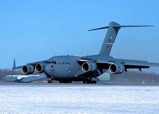
Wright-Patterson Air Force Base (WPAFB) is a United States Air Force base and census-designated place just east of Dayton, Ohio, in Greene and Montgomery counties. It includes both Wright and Patterson Fields, which were originally Wilbur Wright Field and Fairfield Aviation General Supply Depot. Patterson Field is approximately 16 kilometres (10 mi) northeast of Dayton; Wright Field is approximately 8.0 kilometres (5 mi) northeast of Dayton.
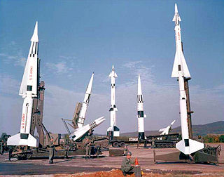
Project Nike was a U.S. Army project, proposed in May 1945 by Bell Laboratories, to develop a line-of-sight anti-aircraft missile system. The project delivered the United States' first operational anti-aircraft missile system, the Nike Ajax, in 1953. A great number of the technologies and rocket systems used for developing the Nike Ajax were re-used for a number of functions, many of which were given the "Nike" name . The missile's first-stage solid rocket booster became the basis for many types of rocket including the Nike Hercules missile and NASA's Nike Smoke rocket, used for upper-atmosphere research.

The Marin Headlands are a hilly peninsula at the southernmost end of Marin County, California, United States, located just north of San Francisco across the Golden Gate Bridge, which connects the two counties and peninsulas. The entire area is part of the Golden Gate National Recreation Area. The Headlands are famous for their views of the Bay Area, especially of the Golden Gate Bridge.

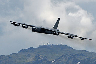
SF-88 is a former Nike Missile launch site at Fort Barry, in the Marin Headlands to the north of San Francisco, California, United States. Opened in 1954, the site was intended to protect the population and military installations of the San Francisco Bay Area during the Cold War, specifically from attack by Soviet bomber aircraft.

Selfridge Air National Guard Base or Selfridge ANGB is an Air National Guard installation located in Harrison Township, Michigan, near Mount Clemens. Selfridge Field was one of thirty-two Air Service training camps established after the United States entry into World War I in April 1917.
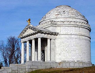
Vicksburg National Military Park preserves the site of the American Civil War Battle of Vicksburg, waged from March 29 to July 4, 1863. The park, located in Vicksburg, Mississippi, also commemorates the greater Vicksburg Campaign which led up to the battle. Reconstructed forts and trenches evoke memories of the 47-day siege that ended in the surrender of the city. Victory here and at Port Hudson, farther south in Louisiana, gave the Union control of the Mississippi River.

The Golden Gate National Recreation Area (GGNRA) is a U.S. National Recreation Area protecting 82,116 acres (33,231 ha) of ecologically and historically significant landscapes surrounding the San Francisco Bay Area. Much of the park is land formerly used by the United States Army. GGNRA is managed by the National Park Service and is the second-most visited unit of the National Park system in the United States, with more than 15.6 million visitors in 2022. It is also one of the largest urban parks in the world, with a size two-and-a-half times that of the consolidated city and county of San Francisco.

Fort MacArthur is a former United States Army installation in San Pedro, Los Angeles, California. A small section remains in military use by the United States Air Force as a housing and administrative annex of Los Angeles Air Force Base. The fort is named after Lieutenant General Arthur MacArthur. His son, Douglas MacArthur, would later command American forces in the Pacific during World War II.

Fort Baker is one of the components of California's Golden Gate National Recreation Area. The Fort, which borders the City of Sausalito in Marin County and is connected to San Francisco by the Golden Gate Bridge, served as an Army post until the mid-1990s, when the headquarters of the 91st Division moved to Parks Reserve Forces Training Area. It is located opposite Fort Point at the entrance to the San Francisco Bay.

Rodeo Beach is a beach in the Golden Gate National Recreation Area located in Marin County, California, United States, two miles north of the Golden Gate Bridge. It is characterized by a spit of around 50 meters width at the mouth of a long embayment, known as Rodeo Lagoon; for much of the year the lagoon is cut off from the ocean, making the beach spit a baymouth bar. Part of the beach is sheltered by cliffs. Rodeo Beach is known for its dark, pebbly sand, its uses for surfing and sunbathing, and its locale as a place for viewing, but not collecting, semi-precious stones. This beach is unique among California beaches in that it is largely made up of coarse, pebbly chert grains, both red and green in color. Its mineral composition sets it apart from every other beach in the state. Surfing is possible throughout the year and at all tidal stages, but is best in summer—although there is a risk of shark attacks. Due to the North bar offshore of this beach it results in big waves in the winter months with the big swells that come in. Strong currents make swimming dangerous.

Fort Tilden, also known as Fort Tilden Historic District, is a former United States Army installation on the coast in the New York City borough of Queens. Fort Tilden now forms part of the Gateway National Recreation Area, and is administered by the National Park Service.
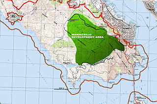
Marincello was a failed development project in Marin County, California that would have put a planned community atop the Marin Headlands, overlooking the Golden Gate. Its upheaval set the precedent for Marin County's rigid anti-development stance and push for open space.

Rodeo Lagoon is a coastal lagoon located in the Marin Headlands division of the Golden Gate National Recreation Area, which is in southern Marin County, California. This brackish water body is separated from the Pacific Ocean by a sand bar that forms Rodeo Beach. Rodeo Lagoon stretches approximately 900 metres (3,000 ft) by 250 metres (820 ft), and is about 2 metres (6.6 ft) deep at its maximum depth. It covers a surface area of about 15 hectares.

Fort Funston is a former harbor defense installation located in the southwestern corner of San Francisco. Formerly known as the Lake Merced Military Reservation, the fort is now a protected area within the Golden Gate National Recreation Area (GGNRA) and is used widely as an off-leash dog park. It was named in honor of Frederick N. Funston (1865–1917), a Major General in the United States Army with strong connections to San Francisco, and included several artillery batteries. The fort is located on Skyline Boulevard at John Muir Drive, west of Lake Merced.

Space Launch Complex 10, or Missile Launch Complex 10, is located on Vandenberg Space Force Base in Lompoc, California. It was built in 1958 to test ballistic missiles and developed into a space launching facility in 1963. Prior to 1966 Space Launch Complex 10 West was known as Vandenberg AFB Pad 75-2-6. It remains a rare pristine look at the electronics and facilities created in that era that helped the United States grow its space capabilities.

The Oakland Army Base, also known as the Oakland Army Terminal, is a decommissioned United States Army base in the San Francisco Bay Area of California. The base was located at the Port of Oakland on Maritime Street just south of the eastern entrance to the San Francisco–Oakland Bay Bridge.

Fort McKinley is a former United States Army coastal defense fort on Great Diamond Island, Maine in Casco Bay, which operated from 1873 to 1947. It was named for President William McKinley. It included a sub-post, Fort Lyon, on Cow Island, just north of Great Diamond Island. Fort Lyon was named for Nathaniel Lyon. Both forts were part of the Coast Defenses of Portland, renamed the Harbor Defenses of Portland in 1925, a command which protected Portland's port and naval anchorage 1895-1950. In 1946 Fort Lyon was closed and turned over to the City of Portland. After Fort McKinley's closure it was transferred to the United States Navy, which sold the site to private interests in 1961. The Fort McKinley Historic District was listed on the National Register of Historic Places in 1985.
The Nike Site Summit is a historic military installation of the United States Army in Anchorage Borough, Alaska. The site, located in the Chugach Mountains overlooking Joint Base Elmendorf–Richardson, is the location of one of the best-preserved surviving Nike-Hercules missile installations in the state. The site's structures include a battery control area, a missile launch area, and several magazines. Units of the 43rd Air Defense Artillery Regiment, USARAL Artillery Group, United States Army Alaska, would have garrisoned the site. The site was built in 1957-58 and equipped with missiles in 1959. The site was in active service defending the United States from the threat of Soviet air strikes until it was decommissioned in 1979, after which sensitive militarily equipment was removed. The U.S. Army maintained the site into the 1980s before abandoning it. The site was listed on the National Register of Historic Places in 1996. A local non-profit group, Friends of Nike Site Summit, is actively attempting to preserve the site.

Fort Barry is a former United States Army installation on the West Coast of the United States, located in the Marin Headlands of Marin County, California, north of San Francisco. Opened 116 years ago in 1908, the fort was part of the Coast Artillery Corps and operated throughout the 20th century, before its closure and eventual transfer to the National Park Service.
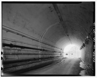
The Baker–Barry Tunnel connects the former military bases Fort Barry and Fort Baker in the Marin Headlands of Marin County, California. The bases are now part of the Golden Gate National Recreation Area. The tunnel is also known as the Bunker Road Tunnel for the road that runs through it, or as the Five-Minute Tunnel because it is only wide enough to accommodate a single reversible lane, opened to traffic at either end for five minute intervals.


