Fort Knokke

Last updated
Fort Knokke
Lo-Reninge, Belgium
Belgium location map.svg
Red pog.svg
Fort Knokke
Coordinates 50°58′48″N2°48′16″E / 50.98°N 2.80444°E / 50.98; 2.80444
TypeVauban-type fort
Site information
Controlled byFlag of Cross of Burgundy.svg  Spain 15841668
Royal Standard of the King of France.svg  France 16681713
Statenvlag.svg  Dutch Republic 1713c. 1750
Banner of the Holy Roman Emperor without haloes (1400-1806).svg Austria c. 17501781
Site history
Built1584
MaterialsEarth and brick
Battles/wars Nine Years' War (1695)
War of Spanish Succession (1712)
War of Austrian Succession (1744)

Fort Knokke or Fort de Cnocke or Fort de la Knocque or Fort de Knocke was an important fortification that defended western Flanders from the 1580s until it was demolished in the 1780s. During its 200 year history, the place was held by the Spanish Empire, Kingdom of France, Habsburg Austria and the Dutch Republic. The existing defenses were improved in 1678 by the famous military engineer Sébastien Le Prestre de Vauban. The fort was attacked by the Grand Alliance in 1695 during the Nine Years' War but the French garrison successfully held out. It was captured from the French by a ruse in 1712 during the War of the Spanish Succession. Control of the fort and other strong places in the Austrian Netherlands was a key feature of the so-called Barrier Treaty in 1713. The French captured the fort after a two-month siege in 1744 during the War of the Austrian Succession. Emperor Joseph II had the citadel demolished in 1781. The site is on the Yser River about 8 kilometres (5 mi) southwest of Diksmuide, Belgium.

Contents

Geography

The site of Fort Knokke is at the confluence of the Yser River and the Ypres Canal (Ieperlee) in the municipality of Lo-Reninge. It is approximately 17 kilometres (11 mi) northwest of Ypres. At the location, a draw bridge (Knokkebrug) spans the Yser a few meters below the junction of the two streams. The trace of the one-time fort can still be clearly seen on a satellite image. [1]

History

On this World War I era map, Fort de Knocke is shown at the confluence of the Yser and the Canal de Yser a Ypres. Note its relationship to Dixmude, Furnes and Nieuport. BATTLE OF THE YSER.jpg
On this World War I era map, Fort de Knocke is shown at the confluence of the Yser and the Canal de Yser à Ypres. Note its relationship to Dixmude, Furnes and Nieuport.

Early history

A fort was first erected at the site by the Spanish between 1584 and 1591 during the Eighty Years' War. The able Spanish general Alexander Farnese, Duke of Parma had captured Ypres and Veurne (Furnes). The fort was intended to block raiding parties of Dutch rebels coming from the port of Ostend. The successful Siege of Ostend removed the Dutch threat in 1604 and the fort fell into disuse. Spain awoke to the location's strategic importance during the Franco-Spanish War. In 1649 a new fort was constructed in the fork between the Yser River and the Ypres Canal. [2]

France acquired the Castellany of Veurne-Ambacht by the Treaty of Aix-la-Chapelle in 1668. King Louis XIV of France wanted a double line of fortresses to protect the northern border of his kingdom. The fortifications expert Sébastien Le Prestre de Vauban immediately noted the importance of its location and set to work redesigning Fort de la Knocque in 1678. The core of the fort was a triangular island on the south side of the streams' confluence. A hornwork and ravelin with brick parapets protected the southeast side. The fort was expanded between 1690 and 1692 with the addition of two bastions, one on the north side and one on the south. Ravelins were added on the east and west sides, while three lunettes completed the defenses. All the new works were constructed of earth. Sometime between 1692 and 1712 a wide moat was added on the east and west sides. [2]

Clash in 1695

Fort de la Knocque was attacked by the Grand Alliance during the Nine Years' War. In June 1695, the army of King William III of England was encamped at Aarsele between Tielt and Deinze. After detaching 11 squadrons of cavalry to join Maximilian II Emanuel, Elector of Bavaria's forces at Ninove, the army moved south on 10 June to threaten the French lines. French commander Marshal François de Neufville, duc de Villeroi put his defenses on alert at Veurne, Fort de la Knocque, Ypres and Menen (Menin). [3]

On 19 June 1695 the Duke of Württemberg with 3,000 soldiers and supporting artillery advanced on Fort de la Knocque. A half-league from the fort was a French outpost on the Yser held by Count de la Mothe and over 400 dragoons. This post was attacked and, though reinforced, it was captured after a tenacious defense. At their newly seized bridgehead, the Allies built a temporary fort and armed it with two cannons. The French constructed a nearby counter-battery and numerous casualties were inflicted on both sides. The Allies tried to expand their bridgehead, but were thwarted by French counter-measures and cannon fire from Fort de la Knocque. After several days of skirmishing, the Allies withdrew on the night of 2627 June. [3]

It is assumed that the move against Fort de la Knocque was a feint attack, intended to distract the French from the Siege of Namur which followed in July. Even if the Allies had managed to widen their small bridgehead, they had to advance through a marsh which it would have been simple for the French to defend. However, the author felt that it was a serious attack and not a feint, because the British and their Dutch allies were particularly interested in seizing places along the Flanders coast. [3]

Capture in 1712

Touraine Regt. 1734 Touraine inf 1734.png
Touraine Regt. 1734

In 1712 when the War of the Spanish Succession was turning against Habsburg Austria, Prince Eugene of Savoy cast about for a way for his shaken troops to gain a success. He heard that the garrison of Fort de Knocque was weak and its security was lax. Eugene called for a partisan named La Rue, told him his plan to surprise the garrison and instructed him to call on the governor of Ostend to give him whatever help he needed. At the same time Eugene alerted Lieutenant General Robert Murray at Lille to hold some troops ready to assist in the coup. La Rue's free company and some troops from Ostend stealthily took position in gardens near the fort where they caught and killed two sentries. La Rue disguised several of his men as peasants with their loaded weapons concealed in a cart. Appearing before the fort, they called out that they wanted to sell their wares to the officers and were admitted. The first group of partisans seized the door to the fort. After that, it was easy for a second disguised group to burst into the fort to find most of the officers and men inside their barracks. A few men raised the alarm but they were rapidly subdued at sword and bayonet point. When Murray arrived, he found the garrison prisoners of war. The general put a Dutch garrison into the fort and returned to Lille. [4] [5]

By the Treaty of Utrecht in 1713, France ceded control of Veurne-Ambacht to the Austrian Netherlands. [2] By a unique arrangement, a line of fortresses in Austrian territory were handed over to the Dutch Republic to provide a barrier against future French invasions. From west to east, these were Veurne, Fort Knokke, Ypres, Menen, Tournai, Mons, Charleroi and Namur. [6]

Siege of 1744

On 26 June 1744 during the War of the Austrian Succession the fort was assaulted by 18 picked French companies under the command of General Boufflers. Evidently the initial attack was a failure because on 28 June the French opened a siege trench on the west side of the fort. When they sapped close to the defenses, the French artillerists established one battery with four cannons and a second battery with four mortars. The fort capitulated to the French on 29 August 1744. The French employed units of the Piemont, Bourbonnais, Rohan, Royal, Touraine, Noailles, Orleans, La Couronne, Richecourt, Valenceau and du Roy Infantry Regiments. The cavalry contingent consisted of elements of the Egemont, La Suze and Mestre de Camp Cavalry Regiments and the Royal and Egemont Dragoons. The map depicting the siege called the fort La Kenoque. The central citadel within the junction of the streams is clearly visible. It is separated from the southern ramparts by a moat, making the citadel an island. There is a bastion on the west bank and another on the east bank. Both are covered by outworks. [7]

Demolition

Fort de la Knocque was described as being located at the confluence of the Yser and Ieperlee at a distance of 1.5 leagues from Diksmuide, 3 leagues from Ypres and 4 leagues from both Veurne and Nieuwpoort (Nieuport). The fort was 750 by 500 feet (pieds) in extent and entry to the fort was through a narrow door. There were only a few casernes for the soldiers to live in, though the fort's commander had his own house and there was a chapel. [8] After the mid-1700s, the fortifications lost much of their purpose. In 1781 Emperor Joseph II ordered Fort Knokke to be "slighted" or dismantled. The fort south of the junction of the Yser and Ypres Canal with its brick parapet was completely removed. The remainder of the raised defenses remain partly preserved amid modern pastureland. [2]

Notes

  1. Google (14 April 2014). "De Knokkebrug" (Map). Google Maps . Google. Retrieved 14 April 2014.
  2. 1 2 3 4 "Fort de Cnocke: De Inventaris van het Bouwkundig Erfgoed". Inventaris Onroerend Erfgoed. Retrieved 14 April 2014.
  3. 1 2 3 Rapin de Thoyras, Paul (1749). Histoire de Angleterre. Vol. 11. p. 370. Retrieved 17 April 2014.
  4. Histoire du Prince Francois Eugene de Savoie, Generalissime des Armees de l'Empereur et de Empire. Vol. 4. Amsterdam & Leipzig: Rastee & Merkus. 1750. pp. 306–308. Retrieved 20 April 2014.
  5. Ferguson, James, ed. (1899). Papers Illustrating the History of the Scots Brigade in the Service of the United Netherlands: 1572-1782. Vol. 2. Edinburgh: Scottish Historical Society. p. 5. This source only provided Murray's first name and rank.
  6. Churchill, Winston (1974). The Age of Revolution. New York, N.Y.: Bantam Books. p. 78.
  7. Viallanes,___ (1744). "Plan des attaques de la Knocke, en 1744" . Retrieved 18 April 2014.
  8. La Seconde Partie de la Quintessence du Guide Fidele du Gand. 1791. p. 46. Retrieved 18 April 2014.

Related Research Articles

<span class="mw-page-title-main">West Flanders</span> Province of Belgium

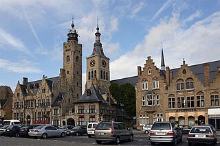
West Flanders is the westernmost province of the Flemish Region, in Belgium. It is the only coastal Belgian province, facing the North Sea to the northwest. It has land borders with the Dutch province of Zeeland to the northeast, the Flemish province of East Flanders to the east, the Walloon province of Hainaut in the south and the French department of Nord to the west. Its capital is Bruges (Brugge). Other important cities are Kortrijk in the south and Ostend (Oostende) on the coast, Roeselare and Ypres (Ieper). The province has an area of 3,197 km2 (1,234 sq mi) which is divided into eight administrative districts (arrondissementen) containing 64 municipalities. As of January 2019, West Flanders has a population of 1,195,796.

<span class="mw-page-title-main">Diksmuide</span> City and municipality in Flemish Community, Belgium

Diksmuide is a Belgian city and municipality in the Flemish province of West Flanders. The municipality comprises the city of Diksmuide proper and the former communes of Beerst, Esen, Kaaskerke, Keiem, Lampernisse, Leke, Nieuwkapelle, Oostkerke, Oudekapelle, Pervijze, Sint-Jacobs-Kapelle, Stuivekenskerke, Vladslo and Woumen.

<span class="mw-page-title-main">Yser</span> River in northern France and western Belgium

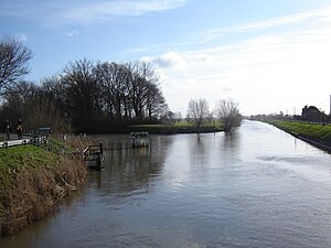
The Yser is a river that rises in French Flanders, enters the Belgian province of West Flanders and flows through the Ganzepoot and into the North Sea at the town of Nieuwpoort.

<span class="mw-page-title-main">Siege of Antwerp (1914)</span> World War I engagement between the German and the Belgian armies

The siege of Antwerp was an engagement between the German and the Belgian, British and French armies around the fortified city of Antwerp during World War I. German troops besieged a garrison of Belgian fortress troops, the Belgian field army and the British Royal Naval Division in the Antwerp area, after the German invasion of Belgium in August 1914. The city, which was ringed by forts known as the National Redoubt, was besieged to the south and east by German forces.

<span class="mw-page-title-main">Battle of the Yser</span> 1914 battle of the First World War

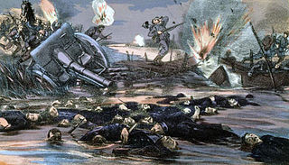
The Battle of the Yser was a battle of the First World War that took place in October 1914 between the towns of Nieuwpoort and Diksmuide, along a 35 km (22 mi) stretch of the Yser River and the Yperlee Canal, in Belgium. The front line was held by a large Belgian force, which halted the German advance in a costly defensive battle.

<span class="mw-page-title-main">Stuivekenskerke</span> Place

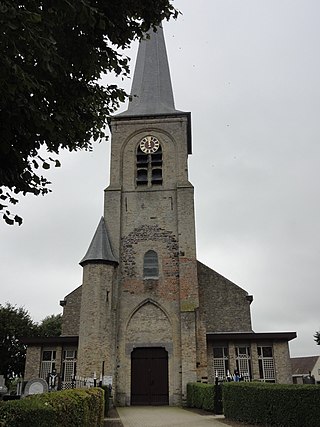
Stuivekenskerke is a district of the town of Diksmuide, in the Belgian province of West Flanders. Located on the Yser river, until 1970 it was an independent municipality and then merged and became a sub-municipality of Diksmuide. Stuivekenskerke, built in a polder, has an area of 7.34 km2 and had 160 inhabitants in 2007.

<span class="mw-page-title-main">Barrier Treaty</span> Series of three Austro-Dutch agreements (1709 - 1715)

The Barrier Treaties were a series of agreements signed and ratified between 1709 and 1715 that created a buffer zone between the Dutch Republic and France by allowing the Dutch to occupy a number of fortresses in the Southern Netherlands, ruled by the Spanish or the Austrians. The treaties were cancelled by Austria in 1781.

<span class="mw-page-title-main">Siege of Namur (1695)</span> 1695 battle of the Nine Years War

The 1695 Siege of Namur or Second Siege of Namur took place during the Nine Years' War between 2 July and 4 September 1695. Its capture by the French in the 1692 and recapture by the Grand Alliance in 1695 are often viewed as the defining events of the war; the second siege is considered to be William III's most significant military success during the war.

<span class="mw-page-title-main">Siege of Lille (1708)</span>

The siege of Lille was the salient operation of the 1708 campaign season during the War of the Spanish Succession. After an obstinate defence of 120 days, the French garrison surrendered the city and citadel of Lille, commanded by Marshal Boufflers, to the forces of the Duke of Marlborough and Prince Eugene.

<span class="mw-page-title-main">Fort Napoleon, Ostend</span> Military Museum in West Flanders, Belgium

Fort Napoleon in Ostend is a polygonal fort built in the Napoleonic era. It has recently been restored and is open to the public.

<span class="mw-page-title-main">German invasion of Belgium (1914)</span> World War I military campaign

The German invasion of Belgium was a military campaign which began on 4 August 1914. On 24 July, the Belgian government had announced that if war came it would uphold its neutrality. The Belgian government mobilised its armed forces on 31 July and a state of heightened alert was proclaimed in Germany. On 2 August, the German government sent an ultimatum to Belgium, demanding passage through the country and German forces invaded Luxembourg. Two days later, the Belgian government refused the German demands and the British government guaranteed military support to Belgium. The German government declared war on Belgium on 4 August; German troops crossed the border and began the Battle of Liège.

<span class="mw-page-title-main">Siege of Ypres (1678)</span>

The siege of Ypres in the Spanish Netherlands took place between March 18 and March 25, 1678, as part of the Franco-Dutch War, and ended with the conquest of the city by the French.

<span class="mw-page-title-main">Armand De Ceuninck</span> Belgium Army general

Armand Léopold Théodore, Baron de Ceuninck was the Minister of War of Belgium, serving in the last year of World War I.

<span class="mw-page-title-main">Hoogstade</span> Village in Flemish Region

Hoogstade is a village in the municipality of Alveringem in the Belgian province of West Flanders. The village is located on the N8. Until 1971, Hoogstade was an independent municipality.

<span class="mw-page-title-main">Yser Front</span>

The Yser Front, sometimes termed the West Flemish Front in British writing, was a section of the Western Front during World War I held by Belgian troops from October 1914 until 1918. The front ran along the Yser river (IJzer) and Yser Canal (Ieperlee) in the far north-west of Belgium and defended a small strip of the country which remained unoccupied. The front was established following the Battle of the Yser in October 1914, when the Belgian army succeeded in stopping the German advance after months of retreat and remained largely static for the duration of the war.

<span class="mw-page-title-main">Siege of Ypres (1794)</span> Siege of the War of the First Coalition

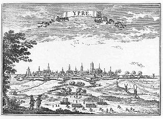
The siege of Ypres saw a Republican French army commanded by Jean-Charles Pichegru invest the fortress of Ypres and its 7,000-man garrison composed of Habsburg Austrians under Paul von Salis and Hessians led by Heinrich von Borcke and Georg von Lengerke. French troops under Joseph Souham fended off three relief attempts by the corps of François Sébastien Charles Joseph de Croix, Count of Clerfayt. Meanwhile, the French besiegers led by Jean Victor Marie Moreau compelled the Coalition defenders to surrender the city. The fighting occurred during the War of the First Coalition, part of the Wars of the French Revolution. In 1794 Ypres was part of the Austrian Netherlands, but today it is a municipality in Belgium, located about 120 kilometres (75 mi) west of Brussels.

<span class="mw-page-title-main">Ieperlee</span> Canalised river in Belgium

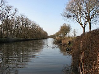
The Ieperlee is a canalized river that rises in Heuvelland in the Belgian province of West Flanders and flows via the city of Ypres (Ieper) into the Yser at Fort Knokke.

The Abbey of Onze-Lieve-Vrouw ter Nieuwe Plant, formerly also Roesbrugge Abbey is a community of Augustinian canonesses belonging to the Congregation of Windesheim. The sisters are informally known as the Roesbrugge Dames - the Roesbrugge Ladies. Located in Roesbrugge from 1239 to the late 16th century, the community then moved into Ypres, West Flanders, Belgium, where it exists today. Its adjacent school is the Lyceum Onze Lieve Vrouw ter Nieuwe Plant.

<span class="mw-page-title-main">Capitulation of Diksmuide</span> 1695 siege of Diksmuide in the Nine Years War

The Capitulation of Diksmuide, or Dixmuide, then in the Spanish Netherlands, took place from 26 to 28 July 1695, during the 1689 to 1697 Nine Years' War. An Allied garrison of around 4,000 men surrendered to a superior French force.

References

External references

50°58′48″N2°48′16″E / 50.98000°N 2.80444°E / 50.98000; 2.80444