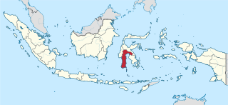
Location of Somba Opu Baruga Somba Opu Samboppe in Indonesia
Fort Somba Opu (Makassarese Baruga Somba Opu, Indonesian Benteng Somba Opu) was a fortified commercial center of the Gowa Sultanate. Its ruins are located in Makassar, South Sulawesi, Indonesia. The fort was the center of the Gowa Sultanate in the 16th-century until its destruction by the Dutch East India Company in 1669. The conquest of Somba Opu citadel was one of the most difficult campaigns the Company had ever undertaken in the East.[1]
Somba Opu grew on one of the two oldest area in Makassar, the Kale Gowa (Tamalate) and the Tallo'. The Kale Gowa was located on elevated ground on the north bank of the Jeneberang River, around six kilometers from its mouth. Both areas feature walls which encompass a very large area; the perimeter totals about two kilometers. Within the walls were sacred coronation stone on which new rulers (karaeng) took their oaths of office, a sacred spring, and the tombs of the rulers.[2] Many Chinese and Sawankhalok porcelain were discovered around these sites, possibly from the 16th century. For Kale Gowa, the walls were built by King Tumapa'risi' Kallonna (1512–1548)[2]
In the 16th century, the karaeng Tunipalangga (1548–1566) gave permission to the Malay merchants to establish a trading port in the port of Makassar. They were allocated a site at Mangallekana, on the coast just south of Jeneberang river. The area quickly became a trade center, which is confirmed by the title of the Shahbandar (port master) of that period, I Daeng ri Mangallekana. The importance of this Malay fort means that a new capital is required near the trade center. So Tunipalangga instructed the construction of a new fortress to the north bank of Jeneberang river, about a kilometer away from the mouth of the Jeneberang at that time.[2]
Somba Opu became the heart of Makassar during the long duumvirate of Sultan Alauddin of Gowa Kingdom and Karaeng Matoaya of Tallo Kingdom (1590–1637). During their reign, there are another additional brick forts around Makassar: at Tallo', at Panakukkang just south of the Jeneberang mouth, and at Ujung Pandang, which later became the Fort Rotterdam; all of these were built to prepared Makassar against the expected Dutch attack in 1615.[3] Somba Opu was the commercial capital of Makassar, while the old Gowa was a ceremonial center for inaugurations or burials. In the 1630s, kings and nobles established their residence in Somba Opu, staying in a house built on thick pillars. According to Dutch maps drawn on a model from the 1630s, a number of detached houses were located in the rear (east) and northern side of the fort. They were grouped around the royal complex in the southwest side of Somba Opu, which consisted of two enormous wooden palaces, storehouses, and a mosque. Outside Somba Opu fort were two major markets each to the north and south, and houses of the commoners. The quarters of the Portuguese, the Indians, and some European factories were located along the north coast.[2]
remnants of the western wall.
Destruction of Somba Opu began with the signing of the Bungaya Treaty in 1667 between the Sultanate and the Dutch, and the subsequent war in 1669.[2] Attack of the fort began with Cornelis Speelman, admiral of the VOC, gathering forces which consisted of 2,000 Bugis soldier, the archrival of Gowa, plus additional 572 men from Ternate, Tidore, Bacan, Butung, and Pampanga (from northern Luzon in the Philippines), 83 Dutch soldiers and 11 Dutch sailors. Speelman divided the Bugismen into six separate entities, among these were those under the command of Arung Palakka, a Bugis prince.[4] Arung Palakka and his retinues were commanded to clear the eastern side of Somba Opu from Makassarese defenders, while the others attempt to breach Somba Opu's walls. Three small Dutch ships and a sloop were set along the Garassi (now the Jeneberang) to attack Somba Opu from the south.[4]
Assault of Somba Opu began on 14 June 1669 with the igniting of the explosives placed in a secret tunnel. The blast created an opening about 27.5 meters in the wall of Somba Opu. The fort defenders reacted by sending 25 warriors to block the attackers from breaching in, while others began to erect wooden stakes to close the hole. Speelman decided to ask for the assistance of the soldiers from Batavia. While Speelman gathered his forces, Somba Opu was reinforced with more troops.[4]
Somba Opu proved a strong fort to be defeated.[5] The attackers suffered 50 dead and 68 wounded, among them were several Dutch and native officers. On 22 June, after a 6 days of continuous rain, Arung Palakka decided to lead his Bugis, Bacan and Ambon soldiers to enter the breach in the wall. The attack by Arung Palakka was fierce, forcing the Somba Opu warriors to abandon the breach as the Bugis and their allies breached in. Despite the rain, the Bugis managed to set up a fire to force the Makassar soldiers to retreat from the eastern and western bastions of the citadel. The Makassar soldiers reestablish their defenses at the southern half of Somba Opu. During the retreat, the Makassar soldiers utilized the largest cannon of Somba Opu, the Anak Mangkasar ("Child of Makassar"), which was heaved over the side of the northwestern bastion. As the Dutch-Bugis army advanced from the west, a report came mentioning that the Makassar forces had fled and abandoned Somba Opu. Sultan Hasanuddin of the Makassar force had not wanted to leave but the flames, fanned by a strong northwesterly wind, forced him to leave.[5] The only Makassarese within the fort were Karaeng Karunrung who remained in the palace surrounded by his kris-wielding followers. The people inside the mosque had also been driven out, only the Malay wife of Datu Soppeng, and all her children, plus 80 of her retinue remained.[6]
As soon as Somba Opu fell, 8,000 Bugis began to seize the booty, among the most sought item were porcelain and copperwork.[1] By the time Speelman and Arung Palakka arrived at the Sultan's residence in Somba Opu, everything had already been stripped bare.[6] The Dutch made certain that Somba Opu would never be used again by throwing all the guns found on the ramparts. There were 33 cannons weighing about 46,000 pounds (21,000kg) and eleven weighing about 24,000 pounds (11,000kg), 145 small guns, 83 gun chambers, 2 stone-throwers, 60 muskets, 23 arquebuses, 127 barrels of muskets and 8,483 bullets.[1] Bricks of the walls of Somba Opu were reused for Dutch buildings or local population's wells and house foundations. The fort dilapidated further because of its location on the delta of Jeneberang. Build-up of the delta buried remnants of Somba Opu, making it inaccessible from both land and sea.[2]
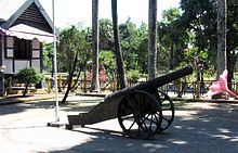
Somba Opu was rediscovered in the 1980s, on the island formed by two major mouths of the present Jeneberang river. The fort was reconstructed in 1990. A 9-meter cannon has been discovered in the fort, as well as other artifacts which were collected within a nearby site museum.[2]
The fort is somewhat forgotten. It is strange that very little attention has been paid by either the Dutch or the Indonesians to the strongest fort ever built by Indonesians, as well as the scene of one of the fiercest battles they ever had to fight.[2]
The Fort then and now
A cannon in Somba Opu.
The fort is located in Kampung Sarombe, on the island formed by two major mouths of the present Jeneberang river. Originally it was a rectangular shaped fort about 240 x 500 meters with bastions on each corner. Currently the southern section (150 meter) of the western wall is the most visible, two-thirds of the original western wall.[2] It is a red brick wall of 3.5 meter thick. Part of the reason why this part survived further damage is because a holy tomb located on the southwest bastion. This bastion is now a mound of 6.5 meters high and 13 meters in diameter. It is known as Maccini' Sombala' (Makassarese "the sighting of sails") or Tompo' Bataya (Makassarese "the highest brick-formation"). Maccini' Sombala' was originally the name of the royal palace within Somba Opu, which was built on August 26, 1650, to replace an earlier palace; the name lingered into the bastion centuries later. Another wall extend to the east of the bastion for about 500 meter, broken by flooding at many places. The rear eastern wall can also be traced, though it strangely curves. The once very strong 500-meter-long northern wall is the most difficult to trace. This wall might be washed by a small stream that formed in the past during the development of the delta and washed away the northern part of the ruined fort, as well as its ruined northeast bastion.[2]
The area around the fort is planned a recreation park area containing several remnants of the Gowa Kingdom as well as museums and South Sulawesi traditional house. The Gowa Discovery Amusement Park was established to the east end of the park. There is a concern that the heritage of the fort will be clumsily destroyed with the new development.
South Sulawesi is a province in the southern peninsula of Sulawesi. The Selayar Islands archipelago to the south of Sulawesi is also part of the province. The capital is Makassar. The province is bordered by Central Sulawesi and West Sulawesi to the north, the Gulf of Bone and Southeast Sulawesi to the east, Makassar Strait to the west, and Flores Sea to the south.
Makassar is the capital of the Indonesian province of South Sulawesi. It is the largest city in the region of Eastern Indonesia and the country's fifth-largest urban center after Jakarta, Surabaya, Medan, and Bandung. The city is located on the southwest coast of the island of Sulawesi, facing the Makassar Strait.
The Bugis people, also known as Buginese, are an ethnicity—the most numerous of the three major linguistic and ethnic groups of South Sulawesi, in the south-western province of Sulawesi, third-largest island of Indonesia. The Bugis in 1605 converted to Islam from Animism. The main religion embraced by the Bugis is Islam, with a small minority adhering to Christianity or a pre-Islamic indigenous belief called Tolotang.
Bone was a sultanate in the south-west peninsula of what is now Sulawesi, a province of modern-day Indonesia. It came under Dutch rule in 1905, and was succeeded by the Bone Regency.
Wajoq, also spelled Wajo, Wajo', or Wajok, was a Bugis elective principality in the eastern part of the South Sulawesi peninsula. It was founded in the 15th century, and reached its peak in the 18th century, when it briefly became the hegemon of South Sulawesi replacing Boné. Wajoq retained its independence until it was subdued in the early 20th century by the Dutch colonial government. It continued to exist in some form up to the mid-20th century, when the self-governing entity was transformed into Wajo Regency in the newly independent Republic of Indonesia.
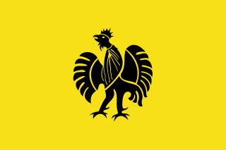
Sultan Hasanuddin (Sultan Hasanuddin Tumenanga Ri Balla Pangkana; was the 16th Ruler of The Sultanate of Gowa as Sombaya Ri Gowa XVI from 1653 to 1669. He was proclaimed as Indonesian National Hero on 6 November 1973. The Dutch called Sultan Hasanuddin "the Rooster of the East" as he was described as aggressive in battle.
Fort Rotterdam is a 17th-century fort in Makassar on the island of Sulawesi in Indonesia. It is a Dutch fort built on top of an existing fort of the Gowa Kingdom. The first fort on the site was constructed by the a local sultan in around 1634, to counter Dutch encroachments. The site was ceded to the Dutch under the Treaty of Bongaya, and they completely rebuilt it between 1673 and 1679. It had six bastions and was surrounded by a seven meter high rampart and a two meter deep moat.
The Sultanate of Bima was a Muslim state in the eastern part of Sumbawa in Indonesia, at the site of the present-day regency of Bima. It was a regionally important polity which formed the eastern limit of Islam in this part of Indonesia and developed an elite culture inspired by Makassarese and Malay models. Bima was subjected to indirect colonial rule from 1669 to 1949 and ceased to be a sultanate in 1958.
The Makassar or Makassarese people are an ethnic group that inhabits the southern part of the South Peninsula, Sulawesi in Indonesia. They live around Makassar, the capital city of the province of South Sulawesi, as well as the Konjo highlands, the coastal areas, and the Selayar and Spermonde islands. They speak Makassarese, which is closely related to Buginese and also a Malay creole called Makassar Malay.
The South Sulawesi expeditions of 1905, which included the Third Bone War and the Gowa War, were undertaken by the Royal Netherlands East Indies Army (KNIL) to force the states of south Sulawesi (Celebes) to sign the Korte Verklaring, the standard agreement whereby a native Indonesian ruler agreed to accept Dutch sovereignty. According to certain Dutch historians, the expeditions were an "obligation", because the Dutch had responsibility for law and order. One Indonesian historian has argued that it was actually strategic: that south Sulawesi was the "key" to controlling the so-called Great East. There was also an economic motive: to extend the tax-collecting powers of the government of Sulawesi. The expeditions received the imprimatur of the Governor of Sulawesi, Alexander Kroesen, in a letter dated 11 February 1904.
The Sultanate of Gowa was one of the great kingdoms in the history of Indonesia and the most successful kingdom in the South Sulawesi region. People of this kingdom come from the Makassar tribe who lived in the south end and the west coast of southern Sulawesi.
The Makassar kingdom of Gowa emerged around 1300 CE as one of many agrarian chiefdoms in the Indonesian peninsula of South Sulawesi. From the sixteenth century onward, Gowa and its coastal ally Talloq became the first powers to dominate most of the peninsula, following wide-ranging administrative and military reforms, including the creation of the first bureaucracy in South Sulawesi. The early history of the kingdom has been analyzed as an example of state formation.
Somba Opu is a district located in the Gowa Regency. South Sulawesi, Indonesia, and is part of the greater Makassar area. Somba Opu is one of 18 districts in Gowa Regency. The capital of Gowa, "Sungguminasa" is located in this district and this is the largest regency capital or 2nd largest town in South Sulawesi. A suburb to Makassar, the district is a relatively urbanized area, and can also be called as the city's bedroom community.
The Trunajaya rebellion or Trunajaya War was the ultimately unsuccessful rebellion waged by the Madurese prince Trunajaya and fighters from Makassar against the Mataram Sultanate and its Dutch East India Company (VOC) supporters in Java during the 1670s.
Arung Palakka, or La Tenritatta to Unru' was a 17th-century Bugis prince and warrior. He supported the Dutch East India Company (VOC) in the Makassar War (1666–1669) against the Gowa Sultanate in his native South Sulawesi. After the defeat of Gowa, he became the King of Bone and South Sulawesi's most powerful man.
I Maninrori Kare Tojeng, also known as Karaeng Galesong, was a Makassarese nobleman and warrior, and a major leader of the Trunajaya rebellion in Java against the Mataram Sultanate. He participated in the successful invasion of East Java and the subsequent rebel victory at Battle of Gegodog (1676). He later broke out with Trunajaya, and built a stronghold in Kakaper, East Java. Dutch East India Company (VOC) and Bugis forces took Kakaper in October 1679, but Galesong escaped and rejoined Trunajaya. He died on 21 November 1679, either by illness or murdered by Trunajaya, before the rebellion ended.
The Kingdom of Tallo was one of the two kingdoms of Makassar in South Sulawesi from the 15th century to 1856. The state stood in a close political relation to the Sultanate of Gowa. After the Islamization of the Gowa and Tallo kingdoms in the early 17th century, they were usually collectively known as the Makassar Kingdom.
Karaeng Pattingalloang (1600–54), was the exceptionally well-read chief minister of the Kingdom of Gowa in South Sulawesi, Indonesia. Pattingalloang was the brilliant second son of Karaeng Matoaya (c.1573-1636), who was the ruler of the Kingdom of Tallo and chief minister (Tuma'bicara-butta) of the partner kingdom of Gowa during its meteoric rise to one of the leading independent ports of Southeast Asia. Pattinggalloang succeeded his father as chief minister from 1639 until his death. The young Pattingalloang must have been partly educated by Portuguese, much the largest European minority in the city, since as an adult he spoke Portuguese "as fluently as people from Lisbon itself". He compiled a substantial library of European books in Portuguese, Spanish and Latin, as well as Malay, and sponsored a number of translations of military manuals into Makassarese. He may have been the first Southeast Asian to understand the importance of mathematics for European scientific and military achievements. French Jesuit Alexandre de Rhodes declared him "exceedingly wise and sensible", despite his Islam. He "had read with curiosity al the chronicles of our European kings. He always had books of ours in hand, especially those treating with mathematics, in which he was quite well versed.".
Ajatappareng was a historical region in the western part of South Sulawesi consisting of five allied principalities: Sidenreng, Suppa, Rappang, Sawitto, Bacukiki and Alitta. They formed an alliance during the sixteenth century in response to the rise of Gowa and Tallo to the south and rivalling the Telumpoccoe alliance—consisting three Bugis kingdoms of Bone, Wajo, and Soppeng—to the east. The Ajatappareng confederation became a regional power and a major port thanks to its naval power and the exodus of traders fleeing the Portuguese capture of Malacca. The confederation's power declined in the seventeenth century, when it was subjugated by Gowa. The later invasion of South Sulawesi by the Dutch East India Company and its imposition of monopoly ended the region's status as a trade centre.
The Makasar script, also known as Ukiri' Jangang-jangang or Old Makasar script, is a historical Indonesian Writing system that was used in South Sulawesi to write the Makassarese language between the 17th and 19th centuries until it was supplanted by the Lontara Bugis script.
Rahim; Ridwan (1975). Sejarah Kerajaan Tallo' (suatu transkripsi lontara')[History of Tallo' Kingdom (a lontar transcription)] (in Indonesian). Ujung Pandang: Lembaga Sejarah dan Antropologi.
This page is based on this Wikipedia article Text is available under the CC BY-SA 4.0 license; additional terms may apply. Images, videos and audio are available under their respective licenses.