
Emsworth is a small town in Hampshire on the south coast of England, near the border of West Sussex. It lies at the north end of an arm of Chichester Harbour, a large and shallow inlet from the English Channel and is equidistant between Portsmouth and Chichester.

Hayling Island is an island off the south coast of England, in the borough of Havant in the county of Hampshire, east of Portsmouth.

Hoy is an island in Orkney, Scotland, measuring 143 square kilometres (55 sq mi) – the second largest in the archipelago, after Mainland. A natural causeway, the Ayre, links the island to the smaller South Walls; the two islands are treated as one entity by the UK census.

Goodwick is a coastal town in Pembrokeshire, Wales, immediately west of its twin town of Fishguard.

Baleshare is a flat tidal island in the Outer Hebrides of Scotland. Baleshare lies to the south-west of North Uist. Its economics and community were boosted by the building of a causeway in 1962. The 350-metre (380 yd) causeway was built by William Tawse Ltd. The island is extremely flat by Hebridean standards, rising to only 12 metres above sea level and known for its long sandy beach. It has a population of 49 living in two settlements: Samhla and Teananachar.

Sully Island is a small tidal island and Site of Special Scientific Interest at the hamlet of Swanbridge, Vale of Glamorgan, 400 yards off the northern coast of the Bristol Channel, midway between the towns of Penarth and Barry and 7 miles south of the Welsh capital city of Cardiff.

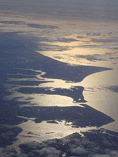
Kaipara Harbour is a large enclosed harbour estuary complex on the north western side of the North Island of New Zealand. The northern part of the harbour is administered by the Kaipara District and the southern part is administered by the Auckland Council. The local Māori tribe is Ngāti Whātua.

Langstone is a village near Havant, Hampshire in the south east of England in Portsmouth. It has good railway connections to London, Southampton, Portsmouth and Brighton, from the nearby Havant railway station. There are many large gated detached houses on the main road, "Langstone Road" and on the roads surrounding this. It has a sailing club, several architecturally unusual buildings, and several historically significant buildings, including a converted (water) millhouse and a converted 18th century windmill, the latter of which is a local landmark.

Spencer Spit State Park is a public recreation area ran under the Washington State Parks. It covers one hundred and thirty-eight acres (56 ha) on the eastern shore of Lopez Island in San Juan County, Washington. It overlooks the Strait of Juan de Fuca. The state park features two sand spits that enclose a salt chuck lagoon that provides a migratory stop for waterfowl, including Bonaparte's gulls. Other local fauna include great blue herons and kingfishers.

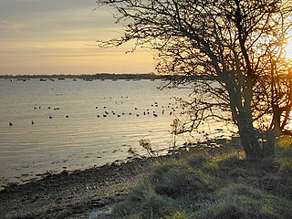
Chichester Harbour is a 3,733.5-hectare (9,226-acre) biological and geological Site of Special Scientific Interest (SSSI) west of Chichester in Hampshire and West Sussex. The SSSI is part of Chichester Harbour Area of Outstanding Natural Beauty and Solent Maritime Special Area of Conservation. It is also part of Chichester and Langstone Harbours Ramsar site, Special Protection Area and Nature Conservation Review site, Grade I. Part of it is a Geological Conservation Review site and two areas are Local Nature Reserves.
Langstone Harbour is a 2,085.4-hectare (5,153-acre) biological Site of Special Scientific Interest in Hampshire. It is an inlet of the English Channel in Hampshire, sandwiched between Portsea Island to the south and west, Hayling Island to the south and east, and Langstone to the north. It is part of Chichester and Langstone Harbours Ramsar site, Special Protection Area and Nature Conservation Review site, Grade I. Parts of it are in Solent Maritime and Solent and Isle of Wight Lagoons Special Areas of Conservation. Three areas are Local Nature Reserves, Farlington Marshes West Hayling and The Kench, Hayling Island. Two areas are nature reserves managed by the Hampshire and Isle of Wight Wildlife Trust, Farlington Marshes and Southmoor Nature Reserve

Cramond Island is one of several islands in the Firth of Forth in eastern Scotland, near Edinburgh. It lies off the foreshore at Cramond. It is 1⁄3 mile (0.54 km) long and covers 19.03 acres (7.70 ha). The island is part of the Dalmeny Estate, owned by the Rosebery Estates Partnership, and is let to Cramond Boat Club.

Warblington railway station serves the Warblington and Denvilles suburbs of Havant in Hampshire.

Langstone Bridge connects Hayling Island with the English mainland of Hampshire.
Selsey Bill is a headland into the English Channel on the south coast of England in the county of West Sussex.
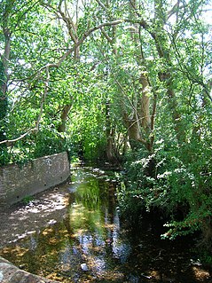
The River Ems is a much-sluiced, 6-mile (9.7 km) river of the far west of West Sussex which for its last 1.5 miles (2.4 km) delimits eastern Hampshire, before flowing into large, coastal Chichester Harbour. Its source is in Stoughton. Along the county-limits part its west bank is the old town portion of Emsworth which has a museum, hospital and is largely pre-1900-built buildings.
The River Roach is a river that flows entirely through the English county of Essex. It is one of four main streams that originate in the Rayleigh Hills to the west, and flow east. They then flow towards the centre of the Rochford Basin, a circular feature which may have been caused by an asteroid impact in the Late Oligocene or Early Miocene periods. To the east of Rochford, the river becomes tidal, and is governed by the Crouch Harbour Authority. It joins the River Crouch between Wallasea Island and Foulness Island. To the west of Rochford, there is some doubt as to which of the four streams is officially the Roach.
![Oronsay, Loch Bracadale Uninhabited tidal island in [[Loch Bracadale]] on the west coast of Skye, Scotland](https://upload.wikimedia.org/wikipedia/commons/thumb/e/e6/Oronsay_.jpg/320px-Oronsay_.jpg)
Oronsay is an uninhabited tidal island in Loch Bracadale on the west coast of Skye, Scotland.

The Hampshire Basin is a geological basin of Palaeogene age in southern England, underlying parts of Hampshire, the Isle of Wight, Dorset, and Sussex. Like the London Basin to the northeast, it is filled with sands and clays of Paleocene and younger ages and it is surrounded by a broken rim of chalk hills of Cretaceous age.

Inner Holm is a small inhabited island in Stromness harbour and one of the Orkney islands of Scotland.
