
Milk River is a tributary of the Missouri River, 729 miles (1,173 km) long, in the U.S. state of Montana and the Canadian province of Alberta. Rising in the Rocky Mountains, the river drains a sparsely populated, semi-arid watershed of 23,800 square miles (62,000 km2), ending just east of Fort Peck, Montana.

Carbon County is a county located in the U.S. state of Montana. As of the 2020 census, the population was 10,473. Its county seat is Red Lodge.
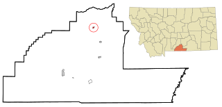
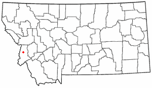
Joliet is a town in Carbon County, Montana, United States. It is part of the Billings, Montana Metropolitan Statistical Area. The population was 577 at the 2020 census.

Red Lodge is a city and county seat of Carbon County, Montana, United States. As of the 2020 census, the population of the city was 2,257.

Deer Lodge is a city in and the county seat of Powell County, Montana, United States. The population was 2,938 at the 2020 census.
The Bitterroot Valley is located in southwestern Montana, along the Bitterroot River between the Bitterroot Range and Sapphire Mountains, in the Northwestern United States.
Boyd is a census-designated place and unincorporated community in Carbon County, Montana, United States. As of the 2010 census it had a population of 35. Boyd was a stop on the Northern Pacific Railway en route to Red Lodge. A post office was first established at Boyd on March 12, 1909 with Roland N. Doughty as the town's first postmaster. Since December 3, 1965, the office has operated as a rural station or a CPO of Roberts with the ZIP code of 59013.
Edgar is a census-designated place and unincorporated community in Carbon County, Montana, United States. As of the 2010 census it had a population of 114. Edgar has a post office with a ZIP code 59026. The post office was established May 28, 1909 with John J. Thornton as its first postmaster. Thornton named the town after his brother.
Luther is an unincorporated community in Carbon County, Montana, United States. Luther lies on Montana Highway 78, southeast of Roscoe and northwest of Red Lodge.

Cooke City is an unincorporated community and census-designated place (CDP) in Park County, Montana, United States. As of the 2010 census, it had a population of 75. Prior to 2010, it was part of the Cooke City-Silver Gate CDP.

Warm Springs is an unincorporated community in Deer Lodge County, Montana, United States. The town can be accessed via exit 201 on Interstate 90.
Moro is an unincorporated community and census-designated place (CDP) in Madison County, Illinois, United States. As of the 2020 census it had a population of 387. Moro, like all of Madison County, is part of the Illinois Metro-East region of the Greater St. Louis metropolitan area.
Holcomb is an unincorporated community in Ogle County, Illinois, United States. Holcomb is 3 miles (4.8 km) south of Davis Junction. Holcomb has a post office with ZIP code 61043. Holcomb was founded in 1876. It was named for William H. Holcomb, General Manager of the Chicago and Iowa Railroad at the time. He was also the Superintendent of Transportation for the World's Columbian Exposition held in Chicago in 1893.

The Regional designations of Montana vary widely within the U.S state of Montana. The state is a large geographical area that is split by the Continental Divide, resulting in watersheds draining into the Pacific Ocean, Gulf of Mexico and Hudson's Bay. The state is approximately 545 miles (877 km) east to west along the Canada–United States border and 320 miles (510 km) north to south. The fourth largest state in land area, it has been divided up in official and unofficial ways into a variety of regions. Additionally, Montana is part of a number of larger federal government administrative regions.
Roberts is a census-designated place and unincorporated town in Carbon County, Montana, United States. As of the 2010 census it had a population of 361.
Molt is an unincorporated rural village located in Stillwater County, Montana, United States, which has a post office ZIP code (59057) and several granaries. A hardware store still stands, which stood as the Prairie Winds cafe for many years; today the building remains unoccupied.

Deer Lodge is an unincorporated community in Morgan County, Tennessee, United States. It is located along Tennessee State Route 329 5.8 miles (9.3 km) west-southwest of Sunbright. Deer Lodge has a post office with ZIP code 37726, which opened on April 16, 1886. The community was established as a health resort in the 1880s by Rugby colonist Abner Ross.
Brady is a census-designated place and unincorporated community in Pondera County, Montana, United States. Its population was 140 as of the 2010 census. Brady has a post office with ZIP code 59416. The community is located along Interstate 15.
Sand Coulee is a census-designated place and unincorporated community in Cascade County, Montana, United States. Its population was 212 as of the 2010 census. Sand Coulee has a post office with ZIP code 59472.
Montaqua is a census-designated place (CDP) in Carbon County, Montana, United States. It is in the northern part of the county, along U.S. Route 212, which leads northeast 15 miles (24 km) to Laurel and southwest 30 miles (48 km) to Red Lodge. Montaqua is on the north side of Rock Creek, a northeast-flowing tributary of the Clarks Fork Yellowstone River. The community is bordered to the northeast by Rockvale.


