Frenchtown, Montana

Last updated

Frenchtown, Montana
Frenchtown Montana near F.jpg
Missoula County Montana Incorporated and Unincorporated areas Frenchtown Highlighted.svg
Location in Missoula County and the state of Montana
Coordinates: 47°01′08″N114°14′46″W / 47.01889°N 114.24611°W / 47.01889; -114.24611
Country United States
State Montana
County Missoula
Area
[1]
  Total6.78 sq mi (17.55 km2)
  Land6.74 sq mi (17.45 km2)
  Water0.04 sq mi (0.10 km2)
Elevation
3,045 ft (928 m)
Population
 (2020) [2]
  Total1,958
  Density290.68/sq mi (112.23/km2)
Time zone UTC-7 (Mountain (MST))
  Summer (DST) UTC-6 (MDT)
ZIP code
59834
Area code 406
FIPS code 30-29350
GNIS feature ID0783746

Frenchtown is an unincorporated community and census-designated place (CDP) in Missoula County, Montana, United States. It is part of the Missoula metropolitan area. The population was 1,958 as of the 2020 census. [2]

Contents

History

Grocery and post office Frenchtown Montana Center.jpg
Grocery and post office

Early settlers gave the location a generic name based on the ethnicity or language of the original settlers, namely French Canadians. [3]

The settlement was cofounded around 1858 by two French Canadians moving inland with their Métis families [4] to escape turmoil further west that followed the arrival of the American federal authorities. Jean-Baptiste Ducharme left Puget Sound during the Indian Wars (1855-1856) abandoning his land claim as his Muck Creek neighbors were arrested under martial law. Louis Brown (anglicized name) left the Colville Valley turmoil a few years later with his Pend d'Oreille wife and their daughters. Meanwhile the Kalispel Indian Community had moved upriver to a new locale accompanied by Jesuit priest Father Hoecken, who relocated the Saint-Ignatius mission northeast of the future Frenchtown.

The St. Louis Catholic Church was built in 1864.

A post office called Frenchtown was first established in 1868. [5]

Geography

Frenchtown is located in northwestern Missoula County on the historic Mullan Road. [6] Interstate 90 now passes through the community, with access from Exit 89. I-90 leads southeast 16 miles (26 km) to Missoula and northwest 42 miles (68 km) to Superior.

Frenchtown Pond State Park is in the western part of the community. The 18-acre (7.3 ha) pond is a popular site for swimming and paddling sports. It offers four-season fishing for bass, perch and hatchery trout. [7]

South of town is the Clark Fork River and the foothills of the Bitterroot Mountains.

According to the U.S. Census Bureau, the Frenchtown CDP has a total area of 6.78 square miles (17.6 km2), of which 0.04 square miles (0.10 km2), or 0.59%, are water. [1] Mill Creek passes through the center of Frenchtown, while Roman Creek and Houle Creek cross the western portion of the CDP. All three creeks are tributaries of the Clark Fork to the south.

Demographics

Historical population
CensusPop.Note
2000 883
2010 1,825106.7%
2020 1,9587.3%
U.S. Decennial Census [8]

As of the census [9] of 2010, there were 1,825 people, 291 households, and 235 families residing in the CDP. The population density was 271.8 inhabitants per square mile (104.9/km2). There were 302 housing units at an average density of 92.9 per square mile (35.9/km2). The racial makeup of the CDP was 96.15% White, 1.59% Native American, 0.11% Asian, 0.79% from other races, and 1.36% from two or more races. Hispanic or Latino of any race were 1.81% of the population.

There were 291 households, out of which 47.4% had children under the age of 18 living with them, 67.0% were married couples living together, 7.9% had a female householder with no husband present, and 19.2% were non-families. 12.7% of all households were made up of individuals, and 4.1% had someone living alone who was 65 years of age or older. The average household size was 3.03 and the average family size was 3.32.

In the CDP, the population was spread out, with 34.3% under the age of 18, 6.5% from 18 to 24, 31.3% from 25 to 44, 22.7% from 45 to 64, and 5.3% who were 65 years of age or older. The median age was 34 years. For every 100 females, there were 106.3 males. For every 100 females age 18 and over, there were 101.4 males.

The median income for a household in the CDP was $46,094, and the median income for a family was $45,938. Males had a median income of $36,118 versus $23,750 for females. The per capita income for the CDP was $21,225. None of the population or families were below the poverty line.

Smurfit-Stone mill

Smurfit-Stone, Frenchtown, MT Smurfit Stone Frenchtown Montana 4.jpg
Smurfit-Stone, Frenchtown, MT
View of main equipment hall from control room balcony, September 2020. Control room balcony.jpg
View of main equipment hall from control room balcony, September 2020.
A small diesel locomotive abandoned at the mill's loading docks. Smurfit-Stone switching engine.jpg
A small diesel locomotive abandoned at the mill's loading docks.

In September 2015, the EPA announced that it was close to an agreement for testing and environmental remediation of Frenchtown's Smurfit-Stone Container Corp. mill site. [10] Contaminants on the site include dioxins and heavy metals, which has raised concerns that the site might be eligible for the federal Superfund list. [11] The paper mill, which produced containerboard, "began production in 1957 under Waldorf Paper Products Co. of St. Paul, MN." [12] The mill employed 417 workers at the time of its closure in 2010. [13] A meeting was held in February 2017 to create a Community Advisory Group to work with the Superfund grantmaking process. Cleanup of PCBs at the mill site was ongoing as of April 2017. [14] As the second largest taxpayer in Missoula county, the mill was the source of nearly 20% ($134281) of the Frenchtown fire district's budget, and 21.7% ($825,976) of the Frenchtown school district's budget. [15]

Education

Frenchtown Public Schools, a unified K-12 school district which covers all of the CDP, [16] serves all grade levels for the community [17] The district had 1,463 students enrolled for the 2021-2022 school year. [18] Frenchtown High School's team name is the Broncs. [19]

The Missoula Public Library has a branch location in Frenchtown. [20]

Media

Missoula Community Radio owns the station KFGM-FM, which is licensed in Frenchtown. [21]

The newspaper provider is the Missoulian, based in nearby Missoula.

Infrastructure

Interstate 90 runs through the southern part of the community. The intersection of US Route 93 with I-90 is 8 miles (13 km) to the southeast in Wye.

The nearest airport is the Missoula Montana Airport, 10 miles (16 km) to the southeast of Frenchtown.

Related Research Articles

<span class="mw-page-title-main">Missoula County, Montana</span> County in Montana, United States

Missoula County is a county located in the State of Montana. As of the 2020 census, the population was 117,922, making it Montana's third most populous county. Its county seat and most populous city is Missoula. The county was founded in 1860.

<span class="mw-page-title-main">Detroit Beach, Michigan</span> Census-designated place in Michigan, United States

Detroit Beach is an unincorporated community and census-designated place (CDP) in Monroe County in the U.S. state of Michigan. The population was 1,957 at the 2020 census. The CDP is located within Frenchtown Charter Township, and as an unincorporated community, Detroit Beach has no legal autonomy of its own.

<span class="mw-page-title-main">Busby, Montana</span> Census-designated place in Big Horn County, Montana, United States

Busby is a census-designated place (CDP) in Big Horn County, Montana, United States. It is on the Northern Cheyenne reservation. The population was 745 at the 2010 census.

<span class="mw-page-title-main">Bigfork, Montana</span> Unincorporated community in Montana, United States

Bigfork is a census-designated place (CDP) in Flathead County, Montana, United States. It is within Montana's Rocky Mountains. The population was 5,118 at the 2020 census, up from 4,270 in 2010.

<span class="mw-page-title-main">Augusta, Montana</span> Census-designated place in Montana, United States

Augusta is an unincorporated community and census-designated place (CDP) in Lewis and Clark County, Montana, United States. The population was 309 at the 2010 census and rose to 316 in the 2020 census. The most accepted version in the naming of this town is after Augusta Hogan, thought to be the first child born in this town, the daughter of J. D. Hogan, an early rancher.

<span class="mw-page-title-main">Alberton, Montana</span> Town in Montana, United States

Alberton is a town in Mineral County, Montana, United States. The population was 452 at the 2020 census. Alberton was the location of a major chlorine chemical release in 1996. It is the home of Northwest Indian Bible School, a Bible-training institution founded and operated by the Allegheny Wesleyan Methodist Connection.

<span class="mw-page-title-main">St. Regis, Montana</span> Census-designated place in Montana, United States

St. Regis or Saint Regis is an unincorporated community and census-designated place (CDP) in Mineral County, Montana. The population was 313 at the time of the 2020 census.

<span class="mw-page-title-main">Bonner-West Riverside, Montana</span> Census-designated place in Montana, United States

Bonner-West Riverside is a census-designated place (CDP) in Missoula County, Montana, United States, including the unincorporated communities of Bonner, Milltown, West Riverside, and Pinegrove. It is part of the Missoula metropolitan area. The population was 1,690 at the 2020 census.

<span class="mw-page-title-main">Clinton, Montana</span> Census-designated place in Montana, United States

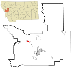
Clinton is an unincorporated community and census-designated place (CDP) in Missoula County, Montana, United States. It is part of the Missoula metropolitan area. The population was 1,018 at the 2020 census.

<span class="mw-page-title-main">East Missoula, Montana</span> Census-designated place in Montana, United States

East Missoula is an unincorporated community and census-designated place (CDP) in Missoula County, Montana, United States. It is part of the Missoula metropolitan area. The population was 2,465 at the 2020 census, up from 2,157 in 2010.

<span class="mw-page-title-main">Evaro, Montana</span> Census-designated place in Montana, United States

Evaro is a census-designated place (CDP) in Missoula County, Montana, United States, and part of the Missoula metropolitan area. It is located on the southernmost part of the Flathead Indian Reservation, approximately 20 miles (32 km) north of downtown Missoula via US Highway 93. As of the 2020 census, the population of the CDP was 373, up from 322 in 2010.

<span class="mw-page-title-main">Lolo, Montana</span> CDP in Montana, United States

Lolo is a census-designated place (CDP) in Missoula County, Montana, United States. It is part of the Missoula Metropolitan Statistical Area. The population was 4,399 at the 2020 census, an increase from its population of 3,892 in 2010. It is home to Travelers' Rest State Park, a site where Lewis and Clark camped in 1805 and again in 1806.

<span class="mw-page-title-main">Missoula, Montana</span> City in Montana, United States

Missoula is a city in and the county seat of Missoula County, Montana, United States. It is located along the Clark Fork River near its confluence with the Bitterroot and Blackfoot rivers in western Montana and at the convergence of five mountain ranges, and thus it is often described as the "hub of five valleys". The 2020 United States census recorded the city's population at 73,489 and the population of the Missoula Metropolitan Area at 117,922. As of 2023, the estimated city population was 77,757. Missoula is the second largest city and metropolitan area in Montana. Missoula is home to the University of Montana, a public research university.

<span class="mw-page-title-main">Seeley Lake, Montana</span> CDP in Montana, United States

Seeley Lake is a census-designated place (CDP) in Missoula County, Montana, United States. It is part of the 'Missoula, Montana Metropolitan Statistical Area'. The town sits beside the 1,031.5 acres lake Seeley Lake. The population was 1,682 at the 2020 census.

<span class="mw-page-title-main">Wye, Montana</span> Place in Montana, United States

Wye is an unincorporated community in Missoula County, Montana, United States. It is part of the Missoula, Montana Metropolitan Statistical Area. The population was 511 at the 2010 census, an increase from its population of 381 in 2000. For statistical purposes, the United States Census Bureau has defined Wye as a census-designated place (CDP). Wye is named for the "y"-shaped DeSmet Junction where US 93 and MT 200 met former US 10.

<span class="mw-page-title-main">Antelope, Montana</span> CDP in Montana, United States

Antelope is a census-designated place (CDP) in Sheridan County, Montana, United States. The population was 51 at the 2010 census.

<span class="mw-page-title-main">Basin, Montana</span> Census-designated place in Montana, United States

Basin is an unincorporated community and census-designated place (CDP) in Jefferson County, Montana, United States. It lies approximately 10 miles (16 km) southeast of the Continental Divide in a high narrow canyon along Interstate 15 about halfway between Butte and Helena. Basin Creek flows roughly north to south through Basin and enters the Boulder River on the settlement's south side. The population was 212 at the 2010 census, down from 255 at the 2000 census.

<span class="mw-page-title-main">Arlee, Montana</span> Census-designated place in Montana, United States

Arlee is an unincorporated community and census-designated place (CDP) on the Flathead Reservation, Lake County, Montana, United States. The population was 725 at the 2020 census. It is named after Alee, a Salish chief. The chief's name has no "r", as the Salish alphabet has no letter "r".

<span class="mw-page-title-main">Libby, Montana</span> City in Montana, United States

Libby is a city in northwestern Montana, United States and the county seat of Lincoln County. The population was 2,775 at the 2020 census.

<span class="mw-page-title-main">KFGM-FM</span> Radio station in Montana, United States

KFGM-FM is a radio station licensed to serve Frenchtown, Montana. The station is owned by a nonprofit, Missoula Community Radio, with studios in the Missoula Public Library and a transmitter on Mount Dean Stone.

References

  1. 1 2 "2023 U.S. Gazetteer Files: Montana". United States Census Bureau. Retrieved June 4, 2024.
  2. 1 2 "P1. Race – Frenchtown CDP, Montana: 2020 DEC Redistricting Data (PL 94-171)". U.S. Census Bureau. Retrieved June 4, 2024.
  3. "Origins of Names on Milwaukee". Roundup Record-Tribune & Winnett Times. August 22, 1940. p. 6. Retrieved April 27, 2015.
  4. Barman, Jean French Canadians, Furs, and Indigenous Women in the Making of the Pacific Northwest. UBC Press. Vancouver 2014. Chapter 7: "Initiating Permanent Settlement"
  5. "Missoula County". Jim Forte Postal History. Retrieved April 27, 2015.
  6. Briggeman, Kim (July 4, 2012). "Road to Frenchtown has changed since Stone's journey". Missoulian. Retrieved October 3, 2015.
  7. "Frenchtown Pond State Park". Montana Fish, Wildlife, and Parks. Retrieved October 4, 2023.
  8. "Census of Population and Housing". Census.gov. Retrieved June 4, 2016.
  9. "U.S. Census website". United States Census Bureau . Retrieved January 31, 2008.
  10. Kidston, Martin (October 3, 2015). "EPA pledges progress in 'month or two' at former Smurfit site". Missoulian . Retrieved October 3, 2015.
  11. Chaney, Rob (September 13, 2012). "Former Frenchtown mill site may need Superfund cleanup". Missoulian. Retrieved October 3, 2015.
  12. Briggeman, Kim (May 5, 2011). "Investment group buys Smurfit's Frenchtown mill" (PDF). Missoulian via logging.com. Retrieved October 3, 2015.
  13. Cohen, Betsy (January 3, 2010). "Smurfit-Stone closure: Towns struggle to put old mill sites to use". Missoulian. Retrieved October 3, 2015.
  14. Briggeman, Kim. "Investigations into PCBs, berms ongoing at Frenchtown Superfund site". missoulian.com. Retrieved July 1, 2017.
  15. Missoulian, BETSY COHEN of the. "Smurfit-Stone to permanently close Frenchtown mill". missoulian.com. Retrieved January 23, 2021.
  16. "2020 CENSUS - SCHOOL DISTRICT REFERENCE MAP: Missoula County, MT" (PDF). U.S. Census Bureau . Retrieved March 13, 2024.
  17. "Frenchtown School District". Frenchtown School District. Retrieved April 13, 2021.
  18. "Frenchtown K-12 Schools". National Center for Education Statistics. Retrieved October 4, 2023.
  19. "Member Schools". Montana High School Association. Retrieved April 19, 2021.
  20. "Hours & Locations". Missoula Public Library. Retrieved April 13, 2021.
  21. "KFGM-FM". FCC. Retrieved October 4, 2023.