
Hartford is the capital city of the U.S. state of Connecticut. It was the seat of Hartford County until Connecticut disbanded county government in 1960. It is the largest city in the Capitol Planning Region, and core city of the Greater Hartford metropolitan area. Census estimates since the 2010 United States census have indicated that Hartford is the fourth-largest city in Connecticut with a 2020 population of 121,054, behind the coastal cities of Bridgeport, New Haven, and Stamford.

Enfield is a town in Hartford County, Connecticut, United States, first settled by John and Robert Pease of Salem, Massachusetts Bay Colony. The town is part of the Capitol Planning Region. The population was 42,141 at the 2020 census. It is bordered by Longmeadow, Massachusetts, and East Longmeadow, Massachusetts, to the north, Somers to the east, East Windsor and Ellington to the south, and the Connecticut River to the west.

Chicopee is a city located on the Connecticut River in Hampden County, Massachusetts, United States. At the 2020 census, the city had a population of 55,560, making it the second-largest city in Western Massachusetts after Springfield. Chicopee is part of the Springfield, Massachusetts Metropolitan Statistical Area. The communities of Chicopee Center (Cabotville), Chicopee Falls, Willimansett, Fairview, Aldenville, Burnett Road, Smith Highlands and Westover are located within the city.
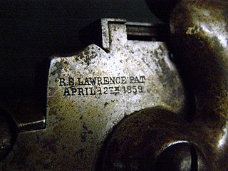
Sharps Rifle Manufacturing Company was the manufacturer of the Sharps Rifle. The company was organized by Samuel Robbins and Richard S. Lawrence as a holding company in Hartford, Connecticut, on October 9, 1851 with $100,000 in capital. Despite Sharps departing from the company bearing his name, Sharps Rifle Manufacturing Company produced over 100,000 rifles, but it dissolved in 1881 with the widespread use of repeating rifles.
Ansonia is a city in New Haven County, Connecticut, United States. Located on the Naugatuck River, it is immediately north of Derby, and about 12 miles (19 km) northwest of New Haven. The city is part of the Naugatuck Valley Planning Region. The population was 18,918 at the time of the 2020 census. The ZIP code for Ansonia is 06401. The city is served by the Metro-North Railroad. Ansonia Station is a stop on the railroad passenger commuter service's Waterbury Branch connecting to New York's Grand Central Terminal. Ansonia also is served by the Connecticut Transit bus carrier. Connecticut Route 8 serves Ansonia.

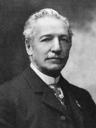
Albert Augustus Pope was a Brevet Lieutenant-Colonel in the Union Army. He was an importer, promoter, and manufacturer of bicycles, and a manufacturer of automobiles.
Charles Ethan Billings (1834–1920) was an American mechanical engineer, inventor, superintendent, and businessman. He held various U.S. patents on hand tools, either assigned or licensed to the firm that he and Christopher M. Spencer cofounded, the Billings & Spencer Company. His name as patent holder is stamped on countless forged hand tools, many of which survive. Billings was an expert in drop forging and was an influential leader in the American system of manufacturing and its successor systems of mass production for firearms, sewing machines, hand tools, bicycles, and other goods. He served as president of the American Society of Mechanical Engineers in 1895 and 1896. The Billings & Spencer Company was both a machine tool builder and a manufacturer of hand tools made with its machine tools.
Pope Manufacturing Company was founded by Albert Augustus Pope around 1876 in Boston, Massachusetts, US and incorporated in Hartford, Connecticut in 1877. Manufacturing of bicycles began in 1878 in Hartford at the Weed Sewing Machine Company factory. Pope manufactured bicycles, motorcycles, and automobiles. From 1905 to 1913, Pope gradually consolidated manufacturing to the Westfield Mass plant. The main offices remained in Hartford. It ceased automobile production in 1915 and ceased motorcycle production in 1918. The company subsequently underwent a variety of changes in form, name and product lines through the intervening years. To this day, bicycles continue to be sold under the Columbia brand.

The neighborhoods of Hartford, Connecticut in the United States are varied and historic.
The history of Connecticut Industry is a major part of the history of Connecticut. Between the birth of the U.S. patent system in 1790 and 1930, Connecticut had more patents issued per capita than any other state; in the 19th century, when the U.S. as a whole was issued one patent per three thousand population, Connecticut inventors were issued one patent for every 700–1000 residents. Connecticut's first recorded invention was a lapidary machine, by Abel Buell of Killingworth, in 1765.

The history of Bridgeport, Connecticut was, in the late 17th and most of the 18th century, one of land acquisitions from the native inhabitants, farming and fishing. From the mid-18th century to the mid-19th century, Bridgeport's history was one of shipbuilding, whaling and rapid growth. Bridgeport's growth accelerated even further from the mid-19th century to the mid-20th century with the advent of the railroad, Industrialization, massive immigration, labor movements until, at its peak population in 1950, Bridgeport with some 159,000 people was Connecticut's second most populous city. In the late 20th century, Bridgeport's history was one of deindustrialization and declining population, though it overtook Hartford as the state's most populous city by 1980.
Bridgeport is the most populous city in the U.S. state of Connecticut and the fifth-most populous city in New England, with a population of 148,654 in 2020. Located in eastern Fairfield County at the mouth of the Pequonnock River on Long Island Sound, it is a port city 60 miles (97 km) from Manhattan and 40 miles (64 km) from The Bronx. It is bordered by the towns of Trumbull to the north, Fairfield to the west, and Stratford to the east. Bridgeport and other towns in Fairfield County make up the Greater Bridgeport Planning Region, as well as the Bridgeport-Stamford-Norwalk-Danbury metropolitan statistical area, the second largest metropolitan area in Connecticut. The Bridgeport-Stamford-Norwalk-Danbury metropolis forms part of the New York metropolitan area.
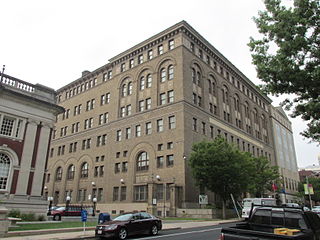
The Elm Street Historic District encompasses a collection of architecturally distinguished institutional and residential buildings near the Connecticut State Capitol in Hartford, Connecticut. Located on Capitol Avenue and Trinity and Elm Streets, it includes the city's best concentration of early 20th-century architecture, including Bushnell Memorial Hall and several state office buildings. It was listed on the National Register of Historic Places in 1984.

The Torrington Company was a firm that developed in Torrington, Connecticut, emerging as a rename from the Excelsior Needle Company. It used a "cold swaging" technique to create sewing machine needles and other needles from cold metal, and was the largest employer in Torrington. in addition to its main facilities in Torrington, it acquired a division, located in South Bend, Indiana.

Christopher Miner Spencer was an American inventor, from Manchester, Connecticut, who invented the Spencer repeating rifle, one of the earliest models of lever-action rifle, a steam powered "horseless carriage", and several other inventions. He developed the first fully automatic turret lathe, which in its small- to medium-sized form is also known as a screw machine.

Colt Park is a city park in the southeast Hartford, Connecticut neighborhood of Sheldon/Charter Oak. The 106-acre (43 ha) park was established from the former Armsmear Estate of Samuel Colt and Elizabeth Jarvis Colt which was gifted to the city upon her death in 1905. Today the park is home to playgrounds, sports fields, a pool and Dillon Stadium. Colt Park was listed on the National Register of Historic Places on June 8, 1976, designated as part of the Colt Industrial District, valued for its association with industrialist Samuel Colt. It is bounded by Wawarme, Wethersfield, Hendricxsen, Van Dyke Avenues and Stonington, Maseek and Sequassen Streets.
The Allen Place–Lincoln Street Historic District encompasses a small neighborhood of late 19th-century housing built for white-collar service workers in southern Hartford, Connecticut. It is roughly bounded by Madison, Washington, and Vernon Streets, and Zion Hill Cemetery, and has well-preserved examples of vernacular Queen Anne and Colonial Revival architecture. It was listed on the National Register of Historic Places in 2003.
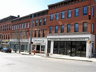
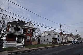
The Bigelow-Hartford Carpet Mills Historic District encompasses a company-built factory and residential area in the Thompsonville area of Enfield, Connecticut. In addition to the former factory buildings of the Bigelow-Hartford Carpet Mills, it includes more than 150 housing units built by the company between about 1830 and 1920. It is roughly bounded on the north by Lafayette Street and Alden Avenue, the east by Hartford Avenue and Lincoln Street, the south by High Street, and the west by River Street. It was listed on the National Register of Historic Places in 1994.

Parkville is a neighborhood on the west side of Hartford, Connecticut. Centered on Park Street and stretching from the railroad overpass just west of Pope Park to the West Hartford town line, and Capitol Avenue to Interstate 84, Parkville is a densely developed, mixed-use neighborhood that is mainly working-class. Its name is derived from its placement at the junction of the North and South Branches of the now-subterranean Park River. Most of the eastern half of the neighborhood was listed as a historic district on the National Register of Historic Places in 2015.

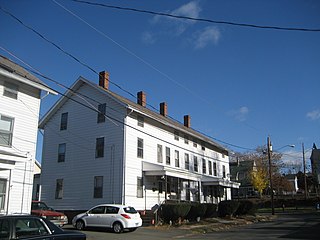
The Underwood Computing Machine Company Factory is a historic industrial complex at 56 Arbor Street in the Parkville neighborhood of Hartford, Connecticut. Developed beginning in 1917 by the Underwood Typewriter Company, it was used by that company and its successors for manufacturing, research, and development until 1969. It presently houses the artistic collaborative Real Art Ways and other organizations. The complex was listed on the National Register of Historic Places in 1989.


