
Galileo is a global navigation satellite system (GNSS) that went live in 2016, created by the European Union through the European Space Agency (ESA), operated by the European Union Agency for the Space Programme (EUSPA), headquartered in Prague, Czechia, with two ground operations centres in Fucino, Italy, and Oberpfaffenhofen, Germany. The €10 billion project is named after the Italian astronomer Galileo Galilei. One of the aims of Galileo is to provide an independent high-precision positioning system so European political and military authorities do not have to rely on the US GPS, or the Russian GLONASS systems, which could be disabled or degraded by their operators at any time. The use of basic (lower-precision) Galileo services is free and open to everyone. A fully encrypted higher-precision service is available for free to government-authorized users. Galileo is intended to provide horizontal and vertical position measurements within 1 m precision. Galileo is also to provide a new global search and rescue (SAR) function as part of the MEOSAR system.

GLONASS is a Russian satellite navigation system operating as part of a radionavigation-satellite service. It provides an alternative to Global Positioning System (GPS) and is the second navigational system in operation with global coverage and of comparable precision.

The European Geostationary Navigation Overlay Service (EGNOS) is a satellite-based augmentation system (SBAS) developed by the European Space Agency and EUROCONTROL on behalf of the European Commission. Currently, it supplements the GPS by reporting on the reliability and accuracy of their positioning data and sending out corrections. The system will supplement Galileo in a future version.
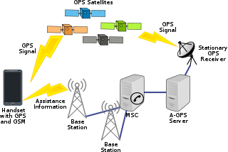
Assisted GNSS (A-GNSS) is a GNSS augmentation system that often significantly improves the startup performance—i.e., time-to-first-fix (TTFF)—of a global navigation satellite system (GNSS). A-GNSS works by providing the necessary data to the device via a radio network instead of the slow satellite link, essentially "warming up" the receiver for a fix. When applied to GPS, it is known as assisted GPS or augmented GPS. Other local names include A-GANSS for Galileo and A-Beidou for BeiDou.

A satellite navigation or satnav system is a system that uses satellites to provide autonomous geopositioning. A satellite navigation system with global coverage is termed global navigation satellite system (GNSS). As of 2023, four global systems are operational: the United States' Global Positioning System (GPS), Russia's Global Navigation Satellite System (GLONASS), China's BeiDou Navigation Satellite System, and the European Union's Galileo.

Differential Global Positioning Systems (DGPSs) supplement and enhance the positional data available from global navigation satellite systems (GNSSs). A DGPS for GPS can increase accuracy by about a thousandfold, from approximately 15 metres (49 ft) to 1–3 centimetres.

Real-time kinematic positioning (RTK) is the application of surveying to correct for common errors in current satellite navigation (GNSS) systems. It uses measurements of the phase of the signal's carrier wave in addition to the information content of the signal and relies on a single reference station or interpolated virtual station to provide real-time corrections, providing up to centimetre-level accuracy. With reference to GPS in particular, the system is commonly referred to as carrier-phase enhancement, or CPGPS. It has applications in land surveying, hydrographic surveying, and in unmanned aerial vehicle navigation.

The Quasi-Zenith Satellite System (QZSS), also known as Michibiki (みちびき), is a four-satellite regional time transfer system and a satellite-based augmentation system developed by the Japanese government to enhance the United States-operated Global Positioning System (GPS) in the Asia-Oceania regions, with a focus on Japan. The goal of QZSS is to provide highly precise and stable positioning services in the Asia-Oceania region, compatible with GPS. Four-satellite QZSS services were available on a trial basis as of 12 January 2018, and officially started on 1 November 2018. A satellite navigation system independent of GPS is planned for 2023 with seven satellites. In May 2023 it was announced that the system would expand to eleven satellites.

SiRF Technology, Inc. was a pioneer in the commercial use of GPS technology for consumer applications. The company was founded in 1995 and was headquartered in San Jose, California. Notable and founding members included Sanjai Kohli, Dado Banatao, and Kanwar Chadha. The company was acquired by British firm CSR plc in 2009, who were in turn subsequently acquired by American company Qualcomm on 13 August 2015.
The GPS-aided GEO augmented navigation (GAGAN) is an implementation of a regional satellite-based augmentation system (SBAS) by the Government of India. It is a system to improve the accuracy of a GNSS receiver by providing reference signals. The Airports Authority of India (AAI)'s efforts towards implementation of operational SBAS can be viewed as the first step towards introduction of modern communication, navigation and surveillance / air traffic management system over the Indian airspace.

Augmentation of a global navigation satellite system (GNSS) is a method of improving the navigation system's attributes, such as precision, reliability, and availability, through the integration of external information into the calculation process. There are many such systems in place, and they are generally named or described based on how the GNSS sensor receives the external information. Some systems transmit additional information about sources of error, others provide direct measurements of how much the signal was off in the past, while a third group provides additional vehicle information to be integrated in the calculation process.
Global Navigation Satellite System (GNSS) receivers, using the GPS, GLONASS, Galileo or BeiDou system, are used in many applications. The first systems were developed in the 20th century, mainly to help military personnel find their way, but location awareness soon found many civilian applications.

Septentrio N.V. is a designer and manufacturer of high-end multi-frequency GNSS receivers. Its main target is to provide GNSS receiver boards and modules for further system integration by Original Equipment Manufacturers (OEMs). Septentrio's core technology is used in various professional fields such as land and airborne surveying, mobile mapping, machine control, precision agriculture, mining, transport, offshore applications, construction, timing and geodesy etc.
In the field of geodesy, Receiver Independent Exchange Format (RINEX) is a data interchange format for raw satellite navigation system data. This allows the user to post-process the received data to produce a more accurate result — usually with other data unknown to the original receiver, such as better models of the atmospheric conditions at time of measurement.

A satellite navigation device, satnav device or satellite navigation receiver is a user equipment that uses one or more of several global navigation satellite systems (GNSS) to calculate the device's geographical position and provide navigational advice. Depending on the software used, the satnav device may display the position on a map, as geographic coordinates, or may offer routing directions.
Precise Point Positioning (PPP) is a global navigation satellite system (GNSS) positioning method that calculates very precise positions, with errors as small as a few centimeters under good conditions. PPP is a combination of several relatively sophisticated GNSS position refinement techniques that can be used with near-consumer-grade hardware to yield near-survey-grade results. PPP uses a single GNSS receiver, unlike standard RTK methods, which use a temporarily fixed base receiver in the field as well as a relatively nearby mobile receiver. PPP methods overlap somewhat with DGNSS positioning methods, which use permanent reference stations to quantify systemic errors.
Locata Corporation is a privately held technology company headquartered in Canberra, Australia, with a fully owned subsidiary in Las Vegas, Nevada. Locata has invented a local positioning system that can either replace or augment Global Positioning System (GPS) signals when they are blocked, jammed or unreliable. Government, commercial and other organizations use Locata to determine accurate positioning as a local backup to GPS.
Inside GNSS (IG) is an international controlled circulation trade magazine and website owned by Gibbons Media and Research LLC. It covers space-based positioning, navigation and timing (PNT) technology for engineers, designers, and policy-makers of global navigation satellite systems (GNSS). In the United States, GNSS is identified mainly with the government-operated Navstar Global Positioning System (GPS). InsideGNSS.com is the complimentary website of online news, events, digital newsletters, and webinars, and archived magazine articles.

u-blox is a Swiss company that creates wireless semiconductors and modules for consumer, automotive and industrial markets. They operate as a fabless IC and design house.
RTCM SC-104 is a communication protocol for sending differential GPS (DGPS) to a GPS receiver from a secondary source like a radio receiver. The standard is named for the Special Committee 104 of the Radio Technical Commission for Maritime Services (RTCM) that created it. The format does not define the source of the messages and has been used with systems as varied as longwave marine radio, communications satellite broadcasts, and internet distribution.