
The Ganges is a trans-boundary river of Asia which flows through India and Bangladesh. The 2,704 km (1,680 mi) river rises in the western Himalayas in the Indian state of Uttarakhand. It flows south and east through the Gangetic plain of North India, receiving the right-bank tributary, the Yamuna, which also rises in the western Indian Himalayas, and several left-bank tributaries from Nepal that account for the bulk of its flow. In West Bengal state, India, a feeder canal taking off from its right bank diverts 50% of its flow southwards, artificially connecting it to the Hooghly river. The Ganges continues into Bangladesh, its name changing to the Padma. It is then joined by the Jamuna, the lower stream of the Brahmaputra, and eventually the Meghna, forming the major estuary of the Ganges Delta, and emptying into the Bay of Bengal. The Ganges-Brahmaputra-Meghna system is the third largest river on earth by discharge.

The Bhagirathi Hooghly River or the 'Bhāgirathi-Hooghly', called the Ganga or the Kati-Ganga in mythological texts, is the eastern distributary of the Ganges River in West Bengal, India, rising close to Giria in Murshidabad. The main distributary of the Ganges then flows into Bangladesh as the Padma. Today there is a man-made canal called the Farakka Feeder Canal connecting the Ganges to the Bhagirathi.

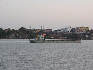
The Padma is a major river in Bangladesh. It is the main distributary of the Ganges, flowing generally southeast for 356 kilometres (221 mi) to its confluence with the Meghna River near the Bay of Bengal. The city of Rajshahi is situated on the banks of the river. Since 1966, over 660 square kilometres (256 sq mi) of land has been lost due to erosion of the Padma.

Bangladesh–India relations, also referred to as Bangladeshi-Bharat relations or Indo-Bangladeshi relations, are the bilateral relations between the People’s Republic of Bangladesh and the Republic of India, both of which are South Asian neighbours. Diplomatic relations between the two countries formally began in 1971 with India's recognition of an independent Bangladesh.

The Indian Rivers Inter-link is a proposed large-scale civil engineering project that aims to effectively manage water resources in India by linking Indian rivers by a network of reservoirs and canals to enhance irrigation and groundwater recharge, reduce persistent floods in some parts and water shortages in other parts of India. India accounts for 18% of the world population and about 4% of the world’s water resources. One of the solutions to solve the country’s water woes is to link rivers and lakes.

Dhuliyan is a municipality town in the Jangipur subdivision of Murshidabad district in the state of West Bengal, India. This municipality was established in the year 1909 and comprises 19 wards. It is located between the Ganges and the Feeder canal.
Farrakka Barrage Township is a census town in the Farakka CD block in the Jangipur subdivision of the Murshidabad district in the state of West Bengal, India.
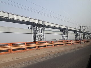
Farakka Barrage is a barrage across the Ganga river located in Murshidabad district in the Indian state of West Bengal, roughly 18 kilometres (11 mi) from the border with Bangladesh near Shibganj. Farakka Barrage Township is located in Farakka in Murshidabad district. Construction of the Farakka barrage started in 1962, was completed in 1970 at a cost of $208 million. Operations began on 21 April 1975. The barrage is about 2,304 metres (7,559 ft) long. The Feeder Canal (Farakka) from the barrage to the Bhagirathi-Hooghly River is about 42 km (26 mi) long.

Pollution of the Ganges, the largest river in India, poses significant threats to human health and the larger environment. The river, which is severely polluted with human waste and industrial contaminants, provides water to about 40% of India's population across 11 states, serving an estimated population of 500 million people, which is more than any other river in the world.
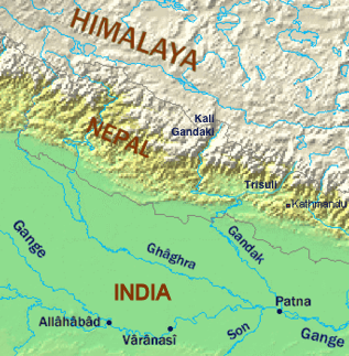
A long-standing dispute exists between India and Bangladesh over the appropriate allocation, and development, of the water resources of the Ganges River, which flows from northern India into Bangladesh. The issue had remained a subject of conflict for almost 35 years, with several bilateral agreements and rounds of talks failing to produce results.
Bihar is India's most flood-prone state, with 76% of population in the North Bihar living under the recurring threat of flood devastation. Bihar makes up 16.5% of India's flood affected area and 22.1% of India's flood affected population. About 73.06% of Bihar's geographical area, i.e. 68,800 square kilometres (26,600 sq mi) out of 94,160 square kilometres (36,360 sq mi), is flood affected. On an annual basis, they destroy thousands of human lives apart from livestock and assets worth millions. In total, they have claimed 9,500 lives since the government started publishing figures in 1979. North Bihar districts are vulnerable to at least five major flood-causing rivers during monsoon – Mahananda River, Koshi River, Bagmati River, Burhi Gandak River and Gandak – which originate in Nepal. Some south Bihar districts have also become vulnerable to floods from Son, Punpun and Phalgu rivers. The 2013 flood affected over 5.9 million people in 3,768 villages in 20 districts of the state. 2017 flood affected 19 districts of North Bihar killing 514 people and affecting 1.71 crore people.
Jangipur subdivision is an administrative subdivision of Murshidabad district in the state of West Bengal, India.

The Kalpasar Project or the Gulf of Khambhat Development Project envisages building a 30 km dam across the Gulf of Khambat in India for establishing a huge fresh water coastal reservoir for irrigation, drinking and industrial purposes. The project with 30 km sea dam will have the capacity to store 10,000 million cubic meters fresh water, equating to 25% of Gujarat’s average annual rainwater flow, from the rivers like Narmada, Mahi, Dhadhar, Sabarmati, Limbdi-Bhagovo, and two other minor rivers. A 10 lane road link will also be set up over the dam, greatly reducing the distance between Saurashtra and South Gujarat. The project, which will create world's largest freshwater lake in marine environment, will cost INR90,000 crore or US$12.75 billion excluding the cost of tidal power plant. Project entails construction of the main "Kalpasar dam" across Gulf of Khambat and another Bhadbhut barrage on Narmada river, as well as a canal connecting the two.

The Padma Multipurpose Bridge, commonly known as the Padma Bridge, is a two-level road-rail bridge across the Padma River, the main distributary of the Ganges in Bangladesh. It connects Louhajang Upazila of Munshiganj and Zazira Upazila of Shariatpur and a small part of Shibchar Upazila of Madaripur, linking the less developed southwest of the country to the northern and eastern regions. The bridge was inaugurated on 25 June 2022 by the Prime Minister Sheikh Hasina.
The National Waterway 1 (NW-1) or Ganga-Bhagirathi-Hooghly river system is located in India and runs from Prayagraj in Uttar Pradesh to Haldia in West Bengal via Patna and Bhagalpur in Bihar across the Ganges river. It is 1,620 km (1,010 mi) long, making it the longest waterway in India. It is of prime importance amongst all the national waterways considering its locational advantages. The NW-1 passes through West Bengal, Jharkhand, Bihar and Uttar Pradesh and serves major cities and their industrial hinterlands like;

Feeder Canal is a canal associated with Farakka Barrage. It is located in Murshidabad district, West Bengal. The canal is 38.3 km(26 miles) long. The Ganges water from the Farakka Dam is being conveyed to Bhagirathi by way of this canal. Due to the flow of river Bhagirathi-Hooghly through the Farakka dam project, around 40,000 cusec of water is available daily in the Feeder connection. The Feeder canal has been designed keeping in mind the ability to carry this amount of water. However, during the dry season, less water is released. The dry season is from January to May. During the period the flow of water in the feeder canal is reduced from 40 thousand cusecs to 30 to 28 thousand cusecs. If the severe drought brings down the Ganges water from its upper reaches, then less water is available in feeder canal.
River bank erosion along the Ganges in Malda and Murshidabad districts focusses on river bank erosion along the main channel of the Ganges in Malda and Mushidabad districts of West Bengal, India.

The Barsoi–New Farakka section is an Indian railway line connecting Barsoi with New Farakka junction on the Howrah–New Jalpaiguri line. This 126-kilometre (78 mi) track is under the jurisdiction of Eastern Railway and Northeast Frontier Railway.

