Related Research Articles

The United States Army Corps of Engineers (USACE) is an engineer formation of the United States Army that has three primary mission areas: Engineer Regiment, military construction, and civil works. The day-to-day activities of the three mission areas are administered by a lieutenant general known as the commanding general/chief of engineers. The chief of engineers commands the Engineer Regiment, comprising combat engineer, rescue, construction, dive, and other specialty units, and answers directly to the Chief of Staff of the Army. Combat engineers, sometimes called sappers, form an integral part of the Army's combined arms team and are found in all Army service components: Regular Army, National Guard, and Army Reserve. Their duties are to breach obstacles; construct fighting positions, fixed/floating bridges, and obstacles and defensive positions; place and detonate explosives; conduct route clearance operations; emplace and detect landmines; and fight as provisional infantry when required. For the military construction mission, the commanding general is directed and supervised by the Assistant Secretary of the Army for installations, environment, and energy, whom the President appoints and the Senate confirms. Military construction relates to construction on military bases and worldwide installations.

The Intracoastal Waterway (ICW) is a 3,000-mile (4,800 km) inland waterway along the Atlantic and Gulf of Mexico coasts of the United States, running from Massachusetts southward along the Atlantic Seaboard and around the southern tip of Florida, then following the Gulf Coast to Brownsville, Texas. Some sections of the waterway consist of natural inlets, saltwater rivers, bays, and sounds, while others are artificial canals. It provides a navigable route along its length without many of the hazards of travel on the open sea.
Internal improvements is the term used historically in the United States for public works from the end of the American Revolution through much of the 19th century, mainly for the creation of a transportation infrastructure: roads, turnpikes, canals, harbors and navigation improvements. This older term carries the connotation of a political movement that called for the exercise of public spirit as well as the search for immediate economic gain. Improving the country's natural advantages by developments in transportation was, in the eyes of George Washington and many others, a duty incumbent both on governments and on individual citizens.

The United States Army Corps of Engineers Mississippi Valley Division (MVD) is responsible for the Corps water resources programs within 370,000-square-miles of the Mississippi River Valley, as well as the watershed portions of the Red River of the North that are within the United States. It encompasses the entire Mississippi River from Lake Itasca, Minnesota, to the Gulf of Mexico. It excludes the watersheds of the Missouri River and Ohio River, and portions of the Arkansas River and the Red River of the South. The division includes all or parts of 13 states: Arkansas, Illinois, Iowa, Kentucky, Louisiana, Michigan, Minnesota, Mississippi, Missouri, North Dakota, Tennessee, Wisconsin, and South Dakota.

The inland waterways of the United States include more than 25,000 mi (40,000 km) of navigable waters. Much of the commercially important waterways of the United States consist of the Mississippi River System—the Mississippi River and connecting waterways.
Charles Ellet Jr. was an American civil engineer from Pennsylvania who designed and constructed major canals, suspension bridges and railroads. He designed and supervised construction of the Wheeling Suspension Bridge, the longest suspension bridge in the world, from 1849 to 1851. He conducted the first Federal survey of the Mississippi and Ohio rivers as part of the U. S. Army Corps of Engineers.
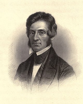
Thomas Jefferson Cram was an American topographical engineer from New Hampshire who served in the United States Army Corps of Topographical Engineers from 1839 to 1863 and the United States Army Corps of Engineers from 1863 to 1869.

The McClellan–Kerr Arkansas River Navigation System (MKARNS) is part of the United States inland waterway system originating at the Tulsa Port of Catoosa and running southeast through Oklahoma and Arkansas to the Mississippi River. The total length of the system is 445 miles (716 km). It was named for two senators, Robert S. Kerr (D-OK) and John L. McClellan (D-AR), who pushed its authorizing legislation through Congress. The system officially opened on June 5, 1971. President Richard M. Nixon attended the opening ceremony. It is operated by the Army Corps of Engineers (USACE).

The history of turnpikes and canals in the United States began with work attempted and accomplished in the original thirteen colonies, predicated on European technology. After gaining independence, the United States grew westward, crossing the Appalachian Mountains with the admission of new states and then doubling in size with the Louisiana Purchase in 1803. The only means of transportation at the time between the coastal states and interior lands remained on water, by canoe, boat and ship, or over land on foot and by pack animal. Recognizing the success of Roman roads in unifying that empire, political and business leaders in the United States began to construct roads and canals to connect the disparate parts of the nation.

The Louisville and Portland Canal was a 2-mile (3.2 km) canal bypassing the Falls of the Ohio River at Louisville, Kentucky. The Falls form the only barrier to navigation between the origin of the Ohio at Pittsburgh and the port of New Orleans on the Gulf of Mexico; circumventing them was long a goal for Pennsylvanian and Cincinnatian merchants. The canal opened in 1830 as the private Louisville and Portland Canal Company but was gradually bought out during the 19th century by the federal government, which had invested heavily in its construction, maintenance, and improvement.
The Water Resources Development Act of 1986 is part of Pub. L.Tooltip Public Law 99–662, a series of acts enacted by Congress of the United States on November 17, 1986.
The Water Resources Development Act of 1990, Pub. L.Tooltip Public Law 101–640, was enacted by Congress of the United States on November 12, 1990. Most of the provisions of WRDA 1990 are administered by the United States Army Corps of Engineers.
The Water Resources Development Act of 1996 is part of Pub. L.Tooltip Public Law 104–303 (text)(PDF), was enacted by Congress of the United States on October 12, 1996. Most of the provisions of WRDA 1996 are administered by the United States Army Corps of Engineers.
Rivers and Harbors Act may refer to one of many pieces of legislation and appropriations passed by the United States Congress since the first such legislation in 1824. At that time Congress appropriated $75,000 to improve navigation on the Ohio and Mississippi rivers by removing sandbars, snags, and other obstacles. Like when first passed, the legislation was to be administered by the United States Army Corps of Engineers (USACE), under its Chief Engineer and the Secretary of War.
Water Resources Development Act of 1976,, Pub. L.Tooltip Public Law 94–587 is a public law enacted on October 22, 1976, by the Congress of the United States of America concerning various water resources and projects.
The Water Resources Development Act of 1992, Pub. L.Tooltip Public Law 102–580, was enacted by Congress of the United States on October 31, 1992. Most of the provisions of WRDA 1992 are administered by the United States Army Corps of Engineers.
The Water Resources Development Act of 1999, Pub. L.Tooltip Public Law 106–53 (text)(PDF), was enacted by Congress of the United States on August 17, 1999. Most of the provisions of WRDA 1999 are administered by the United States Army Corps of Engineers.
The Flood Control Act of 1928 authorized the U.S. Army Corps of Engineers to design and construct projects for the control of floods on the Mississippi River and its tributaries as well as the Sacramento River in California. It was sponsored by Sen. Wesley L. Jones (R) of Washington and Rep. Frank R. Reid (R) of Illinois, in response to the Great Mississippi Flood of 1927.
The Portland District is one of the five districts within the Northwestern Division of the United States Army Corps of Engineers. The Portland District is made up of some 1,100 civilian and 6 military personnel.
The Jefferson Seaway was a proposed deep-draft ship channel to be created in Jefferson Parish, Louisiana, that would establish a route between the Mississippi River at Westwego and the Gulf of Mexico near Grand Isle. The Mississippi River provided the only deep-water access to New Orleans and its neighboring ports. In the mid-20th century, the creation of alternate routes was considered, including the Mississippi River-Gulf Outlet (MR-GO), which was ultimately selected, funded and constructed. The Jefferson Seaway, sometimes referred to as the Arrow to the Americas, the Mississippi Valley Seaway Canal, the Tidewater Ship Canal and the Barataria Canal, was also under consideration but ultimately was never constructed as a deep-draft channel.
References
- 1 2 Improving Transportation Archived 2010-03-28 at the Wayback Machine , USACE
- ↑ Footpathes to Freeway, The Evolution of Michigan Roadmaps, Kathleen Weessies, Michigan State University Library, May 17, 2007
- ↑ "H. Rept. 18-75 - Report of the Committee on Roads and Canals, upon the subject of the navigation of the Ohio and Mississippi Rivers, accompanied with a bill to improve the navigation of the Ohio and Mississippi Rivers. February 28, 1824. Read, and, with the bill, committed to a Committee of the Whole House on Monday next". GovInfo.gov. U.S. Government Printing Office. Retrieved 19 June 2023.
- ↑ During the first half of the 19th century, West Point was the major (and for a while, the only) engineering school in the country. Although part of the nation's small army, the Corps of Engineers was made available to serve the wishes of Congress and the executive branch for civil as well as military work since they were determined to be interdependent.
- 1 2 Army Corps of Engineers, U.S., Water Encyclopedia - Science and Issues
- ↑ Mary Beth Norton, Carol Sheriff, David W. Blight, David M. Katzman, Howard Chudacoff, A People & a Nation: A History of the United States to 1877, p329, Cengage Learning, 2008
- ↑ Forest Hill, Roads, Rails, and Waterways: Army Engineers and Early Transportation, (Norman, OK: Oklahoma University Press, 1957), referenced in Stephen Minicucci, Internal Improvements and the Union, 1790–1860 , Studies in American Political Development (2004), 18: p.160-185, (2004), Cambridge University Press, doi : 10.1017/S0898588X04000094