Geo URI scheme

Last updated

The geo URI scheme is a Uniform Resource Identifier (URI) scheme defined by the Internet Engineering Task Force's RFC 5870 (published 8 June 2010) [1] as:

Contents

a Uniform Resource Identifier (URI) for geographic locations using the 'geo' scheme name. A 'geo' URI identifies a physical location in a two- or three-dimensional coordinate reference system in a compact, simple, human-readable, and protocol-independent way. [1]

The current revision of the vCard specification [2] supports geo URIs in a vCard's "GEO" property, and the GeoSMS standard uses geo URIs for geotagging SMS messages. Android based devices support geo URIs, [3] although that implementation is based on a draft revision of the specification, and supports a different set of URI parameters and query strings.

A geo URI is not to be confused with the former website of GeoURL [4] (which had implemented ICBM addresses).

Example

A simple geo URI might look like:

geo:25.245470718844146,51.45400942457904

where the two numerical values represent latitude and longitude respectively, [1] and are separated by a comma. [1] They are coordinates of a horizontal grid (2D). If a third comma-separated value is present, it represents altitude; [1] so, coordinates of a 3D grid. Coordinates in the Southern and Western hemispheres as well as altitudes below the coordinate reference system (depths) are signed negative with a leading dash. [1]

The geo URI also allows for an optional "uncertainty" value, separated by a semicolon, representing the uncertainty of the location in meters, and is described using the "u" URI parameter. [1] A geo URI with an uncertainty parameter looks as follows:

geo:37.786971,-122.399677;u=35

A geo URI may, for example, be included on a web page, as HTML:

<a href="geo:37.786971,-122.399677;u=35">Wikimedia Headquarters</a>

so that a geo URI-aware user agent such as a web browser could launch the user's chosen mapping service; or it could be used in an Atom feed or other XML file.

Coordinate reference systems

The values of the coordinates only make sense when a coordinate reference system (CRS) is specified. The default CRS is the World Geodetic System 1984 (WGS-84), [1] and it is not recommended to use any other:

The optional 'crs' URI parameter described below may be used by future specifications to define the use of CRSes other than WGS-84. This is primarily intended to cope with the case of another CRS replacing WGS-84 as the predominantly used one, rather than allowing the arbitrary use of thousands of CRSes for the URI (which would clearly affect interoperability). [1]

The only justified use of other CRS today is, perhaps, to preserve projection in large-scale maps, as local UTM, or for non-terrestrial coordinates such as those on the Moon or Mars. The syntax and semantic of the CRS parameter, separated by a semicolon, is described at section 8.3 of RFC 5870. Examples:

The order in which the semicolon-separated parameters occur is partially significant. [1] Whilst the labeltext parameter and future parameters may be given in any order, the crs and the u parameters must come first. If both are used, the crs must precede the u. [1] All parameters are case-insensitive, [1] so, imagining a future new parameter mapcolors, it can be ignored by simpler applications, and the above example is exactly equivalent to:

geo:323482,4306480;CRS=epsg:32718;U=20;mapcolors=for_daltonic

The use of the lowercase representation of parameter names (crsu and mapcolors) is preferred.

Semantics and usual interpretations

The Geo URI scheme semantics, expressed in the section 3.4 of the RFC 5870, is not explicit about some mathematical assumptions, so it is open to interpretation. After ~10 years of its publication, there are some consensual or "most frequently used" assumptions.

Altitude

1. Ocean
2. Reference ellipsoid
3. Local plumb line
4. Continent
5. Geoid Geoida.svg
1. Ocean
2. Reference ellipsoid
3. Local plumb line
4. Continent
5. Geoid

The syntax of the Geo UI defines coordinates as coordinates = coord-a "," coord-b [ "," coord-c ], where coord-c is optional. The semantic of coord-c for WGS-84 is altitude in meters (specifically the "ground elevation", relative to the current geoid Earth Gravitational Model attached to WGS84), [5] and the concept is extended for other coordinates (of non-default CRS).

The RFC explains that "... undefined <altitude> MAY assume that the URI refers to the respective location on Earth's physical surface." However, "... an <altitude> value of 0 MUST NOT be mistaken to refer to 'ground elevation'". [6]

In other words, when an altitude is defined, the measurement is done relative to the geoid (#5; black line in the image), a surface defined by Earth's gravity approximating the mean sea level. When it is undefined, the elevation is assumed to be the altitude of the latitude-longitude point, that is its height (or negative depth) relative to the geoid (i.e. "ground elevation"). A point with a measure "altitude=0" is, however, not to be confused with an undefined value: it refers to an altitude of 0 meters above the geoid.

The use of a geoid stands in contrast to GeoJSON, which uses direct ellipsoid height. [7]

Uncertainty

Facets of the uncertainty. According to ISO 5725-1: accuracy is the proximity of measurement results to the true value; precision is the degree to which repeated (or reproducible) measurements under unchanged conditions show the same results. Accuracy and precision.svg
Facets of the uncertainty. According to ISO 5725-1: accuracy is the proximity of measurement results to the true value; precision is the degree to which repeated (or reproducible) measurements under unchanged conditions show the same results.

Remembering the example above,

geo:37.786971,-122.399677;u=35

The u=35 part informs the uncertainty. As will be showed, geometrically the uncertainty is a disc of radius u in turn of the point of the geo URI.

Geo URI is not about exact abstract positions, strictly it is a location estimate, and we can interpret it (from RFC 5870 and RFC 5491) as the approximate physical position of an object in the Earth's surface.

The RFC 5870 does not formalize the use of the "uncertainty" term. So, in a coarse-statistical or any non-statistical numerical analysis, the GeoURI uncertainty is a condition number. The statistical meaning is implicit, come from the references of the RFC: the only normative reference with something about uncertainty is the RFC 5491 (section 5). The main informative reference, ISO 6709:2008, not use the term "uncertainty", but use the terms "accuracy" and "precision", which are uncertainty facets and can be interpreted in accordance with ISO 5725-1 (illustrated).

Putting all together, adopting these clues, the usual statistical assumptions, and the explicit definitions of the RFC, we obtain the Geo URI's uncertainty mathematical properties:

  1. uncertainty is symmetric: the RFC is explicit, and we can understand it as valid simplification hypothesis. "The single uncertainty value is applied to all dimensions given in the URI" (section 3.4.3). Results in a spherical volume around the point (or a disk by 2D projection).
    By RFC 5491 "locations are expressed as a point (...) and an area or volume of uncertainty around the point".
    • Using RFC 5491, we can suppose that "It is RECOMMENDED that uncertainty is expressed at a confidence of 95% or higher". Therefore, the uncertainty is two standard deviations, 2σ, and it is the radius of the disk that represents uncertainty geometrically.
  2. fixed measure unit: the RFC obligate the use of meters as uncertainty measure units, even when coordinates (CRS) use other (like default that is decimal degrees). It is a semantic and a conversion problem: the
  3. Gaussian error model: RFC say nothing, we interpreting the phrases "amount of uncertainty in the location" and "the uncertainty with which the identified location of the subject is known", all in the context of the normative reference, RFC 5491 (and the informative references like ISO 6709:2008).
  4. total uncertainty: it is only one parameter representing "all uncertainty", the uncertainty in the spatial measure and uncertainty about object definition or object's center. It is a sum of random variables. There is no simplification hypothesis defined to reduce it to a one-variable model.

Imagining the location of an ant colony to illustrate:

The total uncertainty is the sum of GPS error and object-definition error. The latitude and longitude GPS errors need to be simplified (to a disk) and converted into meters. If the errors were inferred from a different model, they need to be converted to the Gaussian model.

Unofficial extensions

Some vendors, such as Android OS, have adopted extensions to the "geo" URI scheme: [9] [10]

Google Maps adopts an unconventional approach to displaying the points: it shows the map for, but does not display a map pin, when a location is given in the standard way. A pin only shows up when given as the query. In other words, to show a pin at the Wikimedia Foundation office, one should not use geo:37.78918,-122.40335 but geo:0,0?q=37.78918,-122.40335 .

See also

Related Research Articles

<span class="mw-page-title-main">Geodesy</span> Science of measuring the shape, orientation, and gravity of the Earth and other astronomical bodies

Geodesy is the science of measuring and representing the geometry, gravity, and spatial orientation of the Earth in temporally varying 3D. It is called planetary geodesy when studying other astronomical bodies, such as planets or circumplanetary systems.

<span class="mw-page-title-main">Latitude</span> Geographic coordinate specifying north–south position

In geography, latitude is a coordinate that specifies the north–south position of a point on the surface of the Earth or another celestial body. Latitude is given as an angle that ranges from –90° at the south pole to 90° at the north pole, with 0° at the Equator. Lines of constant latitude, or parallels, run east–west as circles parallel to the equator. Latitude and longitude are used together as a coordinate pair to specify a location on the surface of the Earth.

A Uniform Resource Identifier (URI) is a unique sequence of characters that identifies a logical or physical resource used by web technologies. URIs may be used to identify anything, including real-world objects, such as people and places, concepts, or information resources such as web pages and books. Some URIs provide a means of locating and retrieving information resources on a network ; these are Uniform Resource Locators (URLs). A URL provides the location of the resource. A URI identifies the resource by name at the specified location or URL. Other URIs provide only a unique name, without a means of locating or retrieving the resource or information about it; these are Uniform Resource Names (URNs). The web technologies that use URIs are not limited to web browsers. URIs are used to identify anything described using the Resource Description Framework (RDF), for example, concepts that are part of an ontology defined using the Web Ontology Language (OWL), and people who are described using the Friend of a Friend vocabulary would each have an individual URI.

<span class="mw-page-title-main">Geographic coordinate system</span> System to specify locations on Earth

The geographic coordinate system (GCS) is a spherical or geodetic coordinate system for measuring and communicating positions directly on the Earth as latitude and longitude. It is the simplest, oldest and most widely used of the various spatial reference systems that are in use, and forms the basis for most others. Although latitude and longitude form a coordinate tuple like a cartesian coordinate system, the geographic coordinate system is not cartesian because the measurements are angles and are not on a planar surface.

<span class="mw-page-title-main">Earth radius</span> Distance from the Earth surface to a point near its center

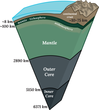
Earth radius is the distance from the center of Earth to a point on or near its surface. Approximating the figure of Earth by an Earth spheroid, the radius ranges from a maximum of nearly 6,378 km (3,963 mi) to a minimum of nearly 6,357 km (3,950 mi).

<span class="mw-page-title-main">Geoid</span> Ocean shape without winds and tides

The geoid is the shape that the ocean surface would take under the influence of the gravity of Earth, including gravitational attraction and Earth's rotation, if other influences such as winds and tides were absent. This surface is extended through the continents. According to Gauss, who first described it, it is the "mathematical figure of the Earth", a smooth but irregular surface whose shape results from the uneven distribution of mass within and on the surface of Earth. It can be known only through extensive gravitational measurements and calculations. Despite being an important concept for almost 200 years in the history of geodesy and geophysics, it has been defined to high precision only since advances in satellite geodesy in the late 20th century.

<span class="mw-page-title-main">Geography Markup Language</span> XML grammar for geographical features

The Geography Markup Language (GML) is the XML grammar defined by the Open Geospatial Consortium (OGC) to express geographical features. GML serves as a modeling language for geographic systems as well as an open interchange format for geographic transactions on the Internet. Key to GML's utility is its ability to integrate all forms of geographic information, including not only conventional "vector" or discrete objects, but coverages and sensor data.

<span class="mw-page-title-main">World Geodetic System</span> Geodetic reference system

The World Geodetic System (WGS) is a standard used in cartography, geodesy, and satellite navigation including GPS. The current version, WGS 84, defines an Earth-centered, Earth-fixed coordinate system and a geodetic datum, and also describes the associated Earth Gravitational Model (EGM) and World Magnetic Model (WMM). The standard is published and maintained by the United States National Geospatial-Intelligence Agency.

<span class="mw-page-title-main">ISO 6709</span> International standard for representation of geographic location

ISO 6709, Standard representation of geographic point location by coordinates, is the international standard for representation of latitude, longitude and altitude for geographic point locations.

<span class="mw-page-title-main">Geodetic datum</span> Reference frame for measuring location

A geodetic datum or geodetic system is a global datum reference or reference frame for precisely representing the position of locations on Earth or other planetary bodies by means of geodetic coordinates. Datums are crucial to any technology or technique based on spatial location, including geodesy, navigation, surveying, geographic information systems, remote sensing, and cartography. A horizontal datum is used to measure a location across the Earth's surface, in latitude and longitude or another coordinate system; a vertical datum is used to measure the elevation or depth relative to a standard origin, such as mean sea level (MSL). Since the rise of the global positioning system (GPS), the ellipsoid and datum WGS 84 it uses has supplanted most others in many applications. The WGS 84 is intended for global use, unlike most earlier datums.

<span class="mw-page-title-main">Satellite geodesy</span> Measurement of the Earth using satellites

Satellite geodesy is geodesy by means of artificial satellites—the measurement of the form and dimensions of Earth, the location of objects on its surface and the figure of the Earth's gravity field by means of artificial satellite techniques. It belongs to the broader field of space geodesy. Traditional astronomical geodesy is not commonly considered a part of satellite geodesy, although there is considerable overlap between the techniques.

<span class="mw-page-title-main">Spatial reference system</span> System to specify locations on Earth

A spatial reference system (SRS) or coordinate reference system (CRS) is a framework used to precisely measure locations on the surface of Earth as coordinates. It is thus the application of the abstract mathematics of coordinate systems and analytic geometry to geographic space. A particular SRS specification comprises a choice of Earth ellipsoid, horizontal datum, map projection, origin point, and unit of measure. Thousands of coordinate systems have been specified for use around the world or in specific regions and for various purposes, necessitating transformations between different SRS.

<span class="mw-page-title-main">Earth-centered, Earth-fixed coordinate system</span> 3-D coordinate system centered on the Earth

The Earth-centered, Earth-fixed coordinate system, also known as the geocentric coordinate system, is a cartesian spatial reference system that represents locations in the vicinity of the Earth as X, Y, and Z measurements from its center of mass. Its most common use is in tracking the orbits of satellites and in satellite navigation systems for measuring locations on the surface of the Earth, but it is also used in applications such as tracking crustal motion.

Geo is a microformat used for marking up geographical coordinates in HTML. Coordinates are expected in angular units of degrees and geodetic datum WGS84. Although termed a "draft" specification, the format is a de facto standard, stable and in widespread use; not least as a sub-set of the published hCalendar and hCard microformat specifications, neither of which is still a draft.

<span class="mw-page-title-main">Earth ellipsoid</span> Shape of planet Earth

An Earth ellipsoid or Earth spheroid is a mathematical figure approximating the Earth's form, used as a reference frame for computations in geodesy, astronomy, and the geosciences. Various different ellipsoids have been used as approximations.

The W3C Geolocation API is an effort by the World Wide Web Consortium (W3C) to standardize an interface to retrieve the geographical location information for a client-side device. It defines a set of objects, ECMAScript standard compliant, that executing in the client application give the client's device location through the consulting of Location Information Servers, which are transparent for the application programming interface (API). The most common sources of location information are IP address, Wi-Fi and Bluetooth MAC address, radio-frequency identification (RFID), Wi-Fi connection location, or device Global Positioning System (GPS) and GSM/CDMA cell IDs. The location is returned with a given accuracy depending on the best location information source available.

GeoSMS is a specification for geotagging SMS messages. It works by embedding locations in the message text, where the locations are formatted as 'geo' URIs as defined in RFC 5870.

<span class="mw-page-title-main">Web Mercator projection</span> Mercator variant map projection

Web Mercator, Google Web Mercator, Spherical Mercator, WGS 84 Web Mercator or WGS 84/Pseudo-Mercator is a variant of the Mercator map projection and is the de facto standard for Web mapping applications. It rose to prominence when Google Maps adopted it in 2005. It is used by virtually all major online map providers, including Google Maps, CARTO, Mapbox, Bing Maps, OpenStreetMap, Mapquest, Esri, and many others. Its official EPSG identifier is EPSG:3857, although others have been used historically.

<span class="mw-page-title-main">Baidu Maps</span> Desktop and mobile web mapping service by Baidu

Baidu Maps is a desktop and mobile web mapping service application and technology provided by Baidu, offering satellite imagery, street maps, street view and indoor view perspectives, as well as functions such as a route planner for traveling by foot, car, or with public transport. Android and iOS applications are available.

Under Chinese law, the use of geographic information in the People's Republic of China is restricted to entities that have special authorization from the administrative department for surveying and mapping under the State Council. Consequences of the restriction include fines for unauthorized surveys, lack of geotagging information on many cameras when the GPS chip detects a location within China, incorrect alignment of street maps with satellite maps in various applications, and the criminalization of crowdsourced mapping efforts such as OpenStreetMap.

References

  1. 1 2 3 4 5 6 7 8 9 10 11 12 "RFC 5870 - A Uniform Resource Identifier for Geographic Locations (geo URI)". Internet Engineering Task Force. 2010-06-08. Retrieved 9 June 2010.
  2. "RFC 6350 - vCard Format Specification". Internet Engineering Task Force. 2011-08-11. Retrieved 19 Jun 2012.
  3. "Android Intents List" . Retrieved 2012-06-19.
  4. "GeoURL (2.0) The GeoURL ICBM Address Server". Geourl.org. Archived from the original on 2013-12-03. Retrieved 2011-12-24. GeoURL is a location-to-URL reverse directory. This will allow you to find URLs by their proximity to a given location. Find your neighbor's blog, perhaps, or the web page of the restaurants near you. GeoURL is listing 9,601,000 sites. Add yourself to the database.
  5. Section 2 of RFC 5870.
  6. Section 3.4.5 of RFC 5870.
  7. Section 4, RFC   7946 – The GeoJSON Format.
  8. Using RFC 5491, that expressed that "... in theory, the area or volume represents a coverage in which the user has a relatively high probability of being found, and the point is a convenient means of defining the centroid for the area or volume" we can use also the concept home range of the ants or the ant's queen, to define the anthill.
  9. "Google Maps Intents for Android | Maps URLs". Google Developers.
  10. "Common Intents (Maps)". Android Developers.