Related Research Articles

The Jervis Bay Territory is an internal territory of Australia. It was established in 1915 from part of New South Wales (NSW), in order to give the landlocked Australian Capital Territory (ACT) access to the sea.

Mount Warning, a mountain in the Tweed Range in the Northern Rivers region of New South Wales, Australia, was formed from a volcanic plug of the now-gone Tweed Volcano. The mountain is located 14 kilometres (9 mi) west-south-west of Murwillumbah, near the border between New South Wales and Queensland. Lieutenant James Cook saw the mountain from the sea and named it Mount Warning.
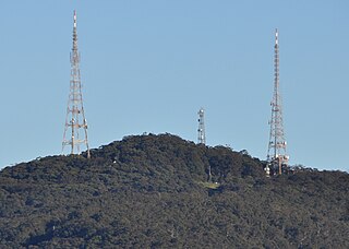
Mount Sugarloaf, also known as Great Sugar Loaf, is a mountain in the lower Hunter Region of New South Wales, Australia, standing at 412 meters, it looks over the cities of Newcastle, Lake Macquarie, Cessnock and Maitland. The summit of the mountain is in the Lake Macquarie suburb of West Wallsend and access to the summit is gained via this suburb. However, the mountain itself is also part of the city of Cessnock suburbs Mulbring and Richmond Vale. It is home to television transmitters that broadcast to the lower Hunter region. On 18 and 19 July 1965, the mountain received 10 centimetres (4 in) of snow. It also snowed on the summit in the winter of 1975.
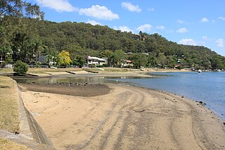
Woronora is a suburb in southern Sydney, in the state of New South Wales, Australia. Woronora is located 27 kilometres south of the Sydney central business district, in the local government area of the Sutherland Shire. Woronora Heights is a separate suburb, to the south-west.
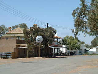
Tibooburra is a town in the far northwest of New South Wales, Australia, located 1,187 kilometres (738 mi) from the state capital, Sydney. It is most frequently visited by tourists on their way to Sturt National Park or on the way to or from Innamincka in South Australia and Birdsville in Queensland. At the 2016 census, Tibooburra had a population of 134. Although facilities in Tibooburra are quite limited, fuel, meals, and a range of accommodation options are available. All significant support services are based in Broken Hill.
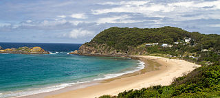
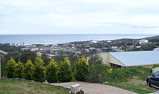
Seal Rocks is a small coastal settlement in the Mid-Coast Council local government area, in the Mid North Coast region of New South Wales, Australia, 275 kilometres (171 mi) north-north-east of Sydney. It is famous for its many premier surfing beaches, and also for being the home of Seal Rocks lighthouse, officially known as Sugarloaf Point Lighthouse. At the 2021 census, the area had a population of 56 persons.

Woodville is a rural suburb in the Hunter Region of New South Wales, Australia that is shared between the Port Stephens and Maitland local government areas (LGA). Most of the suburb lies to the east of the Paterson River in the Port Stephens LGA while a small area of approximately 1.3 square kilometres (0.5 sq mi), to the west of the Paterson, is within the boundaries of the Maitland LGA.
Bucketty is a locality in the City of Cessnock local government area (LGA), in New South Wales, Australia. It is in the south of the LGA, immediately adjacent to the border with the City of Hawkesbury and Central Coast Council, in the Hunter Region, about 105 km (65 mi) north of Sydney, and 55 km (34 mi) from Cessnock, New South Wales, the council seat. Bucketty is presumably the Aboriginal word for mountain spring.

Shoal Bay is the most eastern suburb of the Port Stephens local government area in the Hunter Region of New South Wales, Australia. It is located on the southern shore of Port Stephens, adjacent to the bay of the same name at the entrance to the port. It includes part of Tomaree National Park within its boundaries and, like other suburbs around Port Stephens, is a popular tourist destination, especially in summer months. At the 2021 census the town of Shoal Bay had a population of 1,815 but the population increases significantly during tourist season.

One Mile is a suburb of the Port Stephens local government area in the Hunter Region of New South Wales, Australia. The Worimi people are the traditional owners of the Port Stephens area. The suburb is semi-rural with a small urban settlement, several eco-resorts and back-packer accommodations to the west of Gan Gan Road. On the beach side there is a residential land-lease community and three tourist parks. The parks, two of which have licensed restaurants, are positioned to provide quick access to the suburb's two beaches. Since late 2017 Port Stephens Koala Hospital has been operating in the grounds of Treescape resort.
Boat Harbour is a suburb of the Port Stephens local government area in the Hunter Region of New South Wales, Australia. The main population centre of the suburb is the village also known as Boat Harbour. Both lie adjacent to the bay after which they were named. The traditional owners of the land are Worimi people.

Anna Bay is the name of a suburb, a town and a bay in the Port Stephens local government area in the Hunter Region of New South Wales, Australia. The suburb and town are immediately adjacent to the north-eastern end of Stockton Beach and provide one of the major entry points to the beach at Birubi Point. Both were named after the bay of the same name which is located in the adjacent suburb of One Mile. According to legend to it was originally called Hannah Bay after an alleged shipwreck in 1851 but the vessel has never been identified. The name was changed by post service on 15 May 1896 as many locals were already referring to it as Anna Bay.

Fullerton Cove is a rural suburb of the Port Stephens local government area in the Hunter Region of New South Wales, Australia, located just north of Fern Bay and adjacent to Fullerton Cove, from which the suburb gets its name. The Worimi people are the traditional owners of the Port Stephens area. At the 2021 Australian census the population of Fullerton Cove was 745.
Aboriginal Affairs NSW (AANSW) is an agency of the Department of Premier and Cabinet in the Government of New South Wales. Aboriginal Affairs NSW is responsible for administering legislation in relation to the NSW Government policies that support Indigenous Australians in New South Wales, and for advising the Minister for Aboriginal Affairs, Ben Franklin.

The Kings Tableland is a plateau, located in the Blue Mountains in Wollondilly Shire, New South Wales, Australia. The ridge is an eroded remnant of a sandstone layer that is approximately 1,000 metres (3,300 ft) AMSL, situated immediately south of Wentworth Falls. The Tableland is the major southerly spur of the main spine of the Blue Mountains Range and forms the beginning of the Southern Escarpment, an unbroken series of tall sandstone cliffs which fringes the Jamison, Megalong, Kanimbla and Hartley Valleys.
The Kowmung River, a perennial river that is part of the Hawkesbury-Nepean catchment, is located in the Central Tablelands region of New South Wales, Australia.
The New South Wales Land and Property Information (NSW LPI), a division of the Department of Finance, Services and Innovation in the government of New South Wales, was the division responsible for land titles, property information, valuation, surveying, and mapping and spatial information in the Australian state of New South Wales. From 1 July 2017, the operation was transferred to Australian Registry Investments, a private consortium, under a 35-year concession with the NSW government. The LPI was subsequently renamed and replaced by the NSW Land Registry Services on 1 December 2017.
In Australia, an Aboriginal land trust (ALT) is a type of non-profit organisation that holds the freehold title to an area of land on behalf of a community of Aboriginal Australians. The land has been legally granted to a community by the government under a perpetual lease, usually after the community makes a formal claim of traditional ownership. Land granted under Aboriginal title is inalienable; it can not be bought, sold, traded or given away. The land trust is the organisation appointed by the community to legally hold the title deeds. The land trusts are administered by Aboriginal land councils.
The Department of Customer Service is a department of the New South Wales Government that functions as a service provider to support sustainable government finances, major public works and maintenance programs, government procurement, information and communications technology, corporate and shared services, consumer protection, and land and property administration of the government in New South Wales, Australia.
New South Wales Aboriginal Education Consultative Group Office, abbreviated as NSW Aboriginal Education Consultative Group Office, is a heritage-listed former Aboriginal land, farm and house and now education centre and teacher-training facility at 37 Cavendish Street, Stanmore, Inner West Council, New South Wales, Australia. It was built from 1887 to 1888. It is also known as NSW Aboriginal Education Consultative Group Office and Records and NSW AECG Office. It was added to the New South Wales State Heritage Register on 19 January 2018.
References
- ↑ "About Us". Geographical Names Board of NSW. Retrieved 28 February 2020.
- ↑ "Geographical Names Act, 1966 (NSW)". Australasian Legal Information Institute. Retrieved 27 July 2015.
- ↑ "Traditional placenames". Geographical Names Board. Government of New South Wales. 2009. Archived from the original on 8 November 2011. Retrieved 20 November 2011.