George, Washington

Last updated

George
Gorge Amphitheatre.jpg
The Gorge Amphitheatre in George
Grant County Washington Incorporated and Unincorporated areas George Highlighted.svg
Location of George, Washington
Coordinates: 47°4′42″N119°51′26″W / 47.07833°N 119.85722°W / 47.07833; -119.85722
CountryUnited States
State Washington
County Grant
Area
[1]
  Total1.38 sq mi (3.57 km2)
  Land1.38 sq mi (3.57 km2)
  Water0.00 sq mi (0.00 km2)
Elevation
1,227 ft (374 m)
Population
 (2020) [2]
  Total809
  Density374.73/sq mi (144.64/km2)
Time zone UTC-8 (Pacific (PST))
  Summer (DST) UTC-7 (PDT)
ZIP codes
98824, 98848
Area code 509
FIPS code 53-26455
GNIS feature ID1505105 [3]
Website cityofgeorge.org

George is a city in Grant County, Washington, United States. The population was 809 at the 2020 census. [2] The "humorous homage" to President George Washington has landed George, Washington on lists of unusual place names. [4]

Contents

The city is known for being near The Gorge Amphitheatre, sometimes called "The Gorge at George". The Gorge Amphitheatre was the location of the annual Sasquatch! Music Festival.

The city also celebrates national holidays such as the Fourth of July, and Washington's Birthday, with cherry pies. The world's largest cherry pie is also baked every year on July 4, and served to a crowd. [5]

History

George began as a large irrigation district between Quincy and Moses Lake. In the early 1950s, the need for a town to support the local agriculture business was evident, and the Bureau of Land Management agreed to 339 acres (1.37 km2) for this purpose. The sole bid was that of a local pharmacist, Charlie Brown, who invested his own money into the venture and solicited planning help from a University of Washington instructor. The plan included streets, utilities, etc.

When filing the papers for the town with the BLM, Brown decided that the town should be named after the first President of the United States, George Washington. [6]

The citizens of the town have named their streets after varieties of cherries grown in the area, such as Bing and Royal Anne. [7]

The town was officially incorporated on July 4, 1957, at a ceremony including Governor Albert Rosellini and a 1,000-pound (450 kg) cherry pie. [6] [7]

Geography

According to the United States Census Bureau, the city has a total area of 1.33 square miles (3.44 km2), all of it land. [8]

Climate

According to the Köppen Climate Classification system, George has a cold desert climate, abbreviated "BWk" on climate maps. [9]

Climate data for George, WA
MonthJanFebMarAprMayJunJulAugSepOctNovDecYear
Record high °F (°C)63
(17)
73
(23)
78
(26)
92
(33)
99
(37)
113
(45)
109
(43)
107
(42)
100
(38)
89
(32)
75
(24)
64
(18)
113
(45)
Mean daily maximum °F (°C)36
(2)
44
(7)
55
(13)
64
(18)
73
(23)
81
(27)
88
(31)
88
(31)
78
(26)
64
(18)
47
(8)
37
(3)
63
(17)
Mean daily minimum °F (°C)22
(−6)
27
(−3)
32
(0)
38
(3)
46
(8)
52
(11)
58
(14)
57
(14)
48
(9)
37
(3)
30
(−1)
23
(−5)
39
(4)
Record low °F (°C)−29
(−34)
−25
(−32)
0
(−18)
14
(−10)
21
(−6)
33
(1)
34
(1)
37
(3)
26
(−3)
9
(−13)
−15
(−26)
−19
(−28)
−29
(−34)
Average precipitation inches (mm)0.95
(24)
0.75
(19)
0.71
(18)
0.49
(12)
0.66
(17)
0.55
(14)
0.39
(9.9)
0.33
(8.4)
0.41
(10)
0.57
(14)
1.08
(27)
1.22
(31)
8.11
(206)
Average snowfall inches (cm)4.8
(12)
1.5
(3.8)
0.3
(0.76)
0
(0)
0
(0)
0
(0)
0
(0)
0
(0)
0
(0)
0
(0)
1.2
(3.0)
5
(13)
12.8
(33)
Source: [10]

Demographics

Historical population
CensusPop.Note
1970 273
1980 261−4.4%
1990 253−3.1%
2000 528108.7%
2010 501−5.1%
2020 80961.5%
U.S. Decennial Census [11]
2020 Census [2]

2010 census

At the 2010 census there were 501 people, 131 households, and 109 families living in the city. The population density was 376.7 inhabitants per square mile (145.4/km2). There were 168 housing units at an average density of 126.3 per square mile (48.8/km2). The racial makeup of the city was 38.1% White, 1.4% Native American, 59.9% from other races, and 0.6% from two or more races. 75.0% of all residents were Hispanic or Latino. [12]

Of the 131 households 60.3% had children under the age of 18 living with them, 61.8% were married couples living together, 9.9% had a female householder with no husband present, 11.5% had a male householder with no wife present, and 16.8% were non-families. 8.4% of households were one person and 2.3% were one person aged 65 or older. The average household size was 3.82 and the average family size was 4.14.

The median age was 24.8 years. 35.9% of residents were under the age of 18; 14.9% were between the ages of 18 and 24; 28% were from 25 to 44; 15% were from 45 to 64; and 6.4% were 65 or older. The gender makeup of the city was 54.1% male and 45.9% female.

2000 census

At the 2000 census, there were 528 people, 141 households, and 106 families living in the city. The population density was 879.2 people per square mile (339.8/km2). There were 162 housing units at an average density of 269.8 per square mile (104.2/km2). The racial makeup of the city was 80.11% White, 0.57% Native American, 0.38% Asian, 16.10% from other races, and 2.84% from two or more races. Hispanic or Latino of any race were 60.23% of the population.

Of the 141 households 49.6% had children under the age of 18 living with them, 58.2% were married couples living together, 6.4% had a female householder with no husband present, and 24.8% were non-families. 18.4% of households were one person and 5.7% were one person aged 65 or older. The average household size was 3.74, and the average family size was 4.39. The age distribution was 37.7% under the age of 18, 16.5% from 18 to 24, 26.9% from 25 to 44, 14.0% from 45 to 64, and 4.9% 65 or older. The median age was 23 years. For every 100 females, there were 118.2 males. For every 100 females age 18 and over, there were 140.1 males.

The median household income was $21,181 and the median family income was $23,571. Males had a median income of $21,667 versus $13,875 for females. The per capita income for the city was $7,779. About 33.0% of families and 36.2% of the population were below the poverty line, including 46.8% of those under age 18 and 14.0% of those age 65 or over.

Related Research Articles

<span class="mw-page-title-main">Cherryfield, Maine</span> Town in Maine, United States

Cherryfield is a town in Washington County, Maine, United States on the Narraguagus River. It was named for the wild cherries that once peppered the banks of the river. The town population was 1,107 at the 2020 census. The town bills itself as the "Blueberry Capital of the World". Roughly 75 acres (300,000 m2) on both sides of the river are a historic district on the National Register of Historic Places known as the Cherryfield Historic District. This district comprises a collection of period structures dating from c. 1750–1890. The town was first settled about 1760. In 1826,the part of Steuben known as Narraguagus was annexed onto Cherryfield.

<span class="mw-page-title-main">Washington, Missouri</span> City in the United States

Washington is a city on the south banks of the Missouri River, 50 miles west of St. Louis, Missouri, and the largest in Franklin County, Missouri, United States. The estimated population in July 2022 was 15,075, which is an increase of 3.97% since the 2020 U.S. census. It is notable for being the "corncob pipe capital of the world," with Missouri Meerschaum located on the riverfront.

<span class="mw-page-title-main">Nenzel, Nebraska</span> Village in Cherry County, Nebraska, United States

Nenzel is a village in Cherry County, Nebraska, United States. The population was 17 at the 2020 census.

<span class="mw-page-title-main">Fort Calhoun, Nebraska</span> City in Washington County, Nebraska, United States

Fort Calhoun is a city in Washington County, Nebraska, United States. The population was 1,108 at the 2020 census. The city includes Fort Atkinson, the first fort built west of the Missouri River.

<span class="mw-page-title-main">Diamond, Missouri</span> City in Missouri, United States

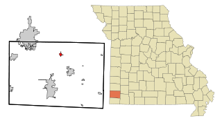
Diamond is a city in north central Newton County, Missouri, United States, located southeast of Joplin. The population was 831 at the 2020 census. It is part of the Joplin, Missouri, Metropolitan Statistical Area. Diamond is primarily renowned as the birthplace of George Washington Carver.

<span class="mw-page-title-main">Cherry Hill Mall, New Jersey</span> Populated place in Camden County, New Jersey, US

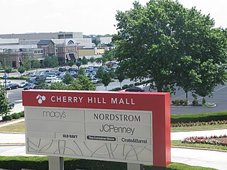
Cherry Hill Mall is an unincorporated community and census-designated place (CDP) located in Cherry Hill, in Camden County, in the U.S. state of New Jersey. As of the 2020 United States census, the CDP’s population was 14,805, its highest decennial count ever and an increase of 634 (+4.5%) from the 14,171 residents recorded at the 2010 census count, which in turn reflected an increase of 933 (+7.0%) from the 13,238 counted in the 2000 census. The CDP is home to the namesake Cherry Hill Mall shopping complex.

<span class="mw-page-title-main">Cherry Grove, Ohio</span> Census-designated place in Ohio, United States

Cherry Grove is a census-designated place (CDP) in Anderson Township, Hamilton County, Ohio, United States. The population was 4,419 at the 2020 census.

<span class="mw-page-title-main">Mingo Junction, Ohio</span> Village in Ohio, United States

Mingo Junction is a village in eastern Jefferson County, Ohio, United States, along the Ohio River. The population was 3,347 at the 2020 census. It is part of the Weirton–Steubenville metropolitan area.

<span class="mw-page-title-main">Venango Township, Butler County, Pennsylvania</span> Township in Pennsylvania, United States

Venango Township is a township that is located in Butler County, Pennsylvania, United States. The population was 869 at the time of the 2020 census.

<span class="mw-page-title-main">Forks Township, Sullivan County, Pennsylvania</span> Township in Pennsylvania, United States

Forks Township is a township in Sullivan County, Pennsylvania, United States. The population was 372 at the 2020 census.

<span class="mw-page-title-main">Smith Township, Washington County, Pennsylvania</span> Township in Pennsylvania, United States

Smith Township is a township in Washington County, Pennsylvania, United States. As of the 2020 census, the township population was 4,224.

<span class="mw-page-title-main">Cherry Grove, Washington</span> Census-designated place in Washington, United States

Cherry Grove is a census-designated place (CDP) in Clark County, Washington, United States. The population was 588 at the 2020 census.

<span class="mw-page-title-main">Quincy, Washington</span> City in Washington, United States

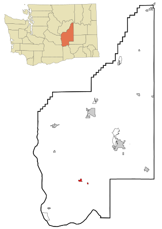
Quincy is a city in Grant County, Washington, United States. It is situated east of the Columbia River on State Route 28 and north of Interstate 90. The population was 7,543 at the 2020 census. Quincy is one of the closest cities to The Gorge Amphitheatre.

<span class="mw-page-title-main">Royal City, Washington</span> City in Washington, United States

Royal City is a city in Grant County, Washington, United States. The population was 1,776 at the 2020 census.

<span class="mw-page-title-main">White Salmon, Washington</span> City in Washington, United States

White Salmon is a city in Klickitat County, Washington, United States. It is located in the Columbia River Gorge. The population was 2,193 at the 2000 census, increased 1.4% to 2,224 at the 2010 census, and increased 11.7% to 2,485 at the 2020 census.

<span class="mw-page-title-main">Stevenson, Washington</span> City in Washington, United States

Stevenson is a city in the Columbia River Gorge National Scenic Area along the Columbia River in Skamania County, Washington, United States. It is the county seat of Skamania County and home to the Skamania County Court House and Sheriff's Office. The population was 1,491 at the 2020 census.

<span class="mw-page-title-main">Grandview, Washington</span> City in Washington, United States

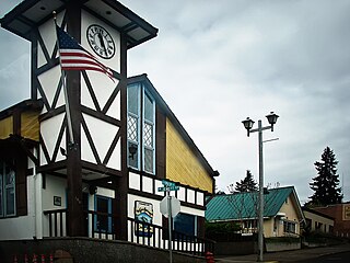
Grandview is a city in Yakima County, Washington, United States. It is about 38 miles west of Kennewick and 38 miles southeast of Yakima. The population was 10,907 at the 2020 census. Grandview's economy is agriculture based; with apples, cherries, concord and wine grapes, hops, asparagus, corn, wheat, dairy and other fruit and vegetable production supported by processing plants and cold storage facilities.

<span class="mw-page-title-main">Naches, Washington</span> Town in Washington, United States

Naches is a town in Yakima County, Washington, United States. The population was 1,084 at the 2020 census.

<span class="mw-page-title-main">Braham, Minnesota</span> City in Minnesota, United States

Braham is a city in Isanti and Kanabec counties in the U.S. state of Minnesota. The population was 1,769 at the 2020 census.

<span class="mw-page-title-main">Carson, Washington</span> CDP in Washington, United States

Carson is a small census-designated place in the Columbia River Gorge National Scenic Area, north of the Columbia River in Skamania County, in the southwestern part of Washington, United States. The population was 2,323 at the 2020 census.

References

  1. "2019 U.S. Gazetteer Files". United States Census Bureau. Retrieved August 7, 2020.
  2. 1 2 3 "2020 Census Redistricting Data (Public Law 94-171) Summary File". American FactFinder. United States Census Bureau . Retrieved March 18, 2022.
  3. "George". Geographic Names Information System . United States Geological Survey, United States Department of the Interior.
  4. "The Oddest Named Town in Every State". The Active Times. April 19, 2018. Retrieved July 3, 2019.
  5. "Largest cherry pie: George, Washington sets world record". World Record Academy. Retrieved May 14, 2014.
  6. 1 2 "A Brief History of the City of George, Washington". City of George. Retrieved November 28, 2021.
  7. 1 2 Steigmeyer, Rick (December 2, 2010). "Fields of dreams: George's unrealized potential". Wenatchee World .
  8. "US Gazetteer files 2010". United States Census Bureau. Archived from the original on January 12, 2012. Retrieved December 19, 2012.
  9. "George Weather | George WA | Conditions, Forecast, Average".
  10. "Zipcode 98824". www.plantmaps.com. Retrieved June 28, 2021.
  11. United States Census Bureau. "Census of Population and Housing" . Retrieved October 2, 2013.
  12. "U.S. Census website". United States Census Bureau . Retrieved December 19, 2012.

See also